Related Research Articles

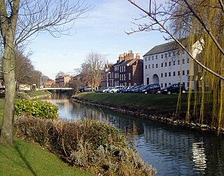
The River Witham is a river almost entirely in the county of Lincolnshire in the east of England. It rises south of Grantham close to South Witham at SK8818, passes through the centre of Grantham, passes Lincoln at SK9771 and at Boston, TF3244, flows into The Haven, a tidal arm of The Wash, near RSPB Frampton Marsh. The name "Witham" seems to be extremely old and of unknown origin. Archaeological and documentary evidence shows the importance of the Witham as a navigable river from the Iron Age onwards. From Roman times it was navigable to Lincoln, from where the Fossdyke was constructed to link it to the River Trent. The mouth of the river moved in 1014 following severe flooding, and Boston became important as a port.

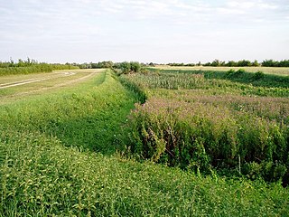
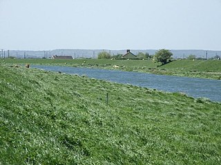
The Fens, also known as the Fenlands, in eastern England are a naturally marshy region supporting a rich ecology and numerous species. Most of the fens were drained centuries ago, resulting in a flat, dry, low-lying agricultural region supported by a system of drainage channels and man-made rivers and automated pumping stations. There have been unintended consequences to this reclamation, as the land level has continued to sink and the dykes have been built higher to protect it from flooding.
The River Glen is a river in Lincolnshire, England with a short stretch passing through Rutland near Essendine.
Spalding is a market town on the River Welland in the South Holland district of Lincolnshire, England. The town had a population of 31,588 at the 2011 census. The town is the administrative centre of the South Holland District. The town is located between the cities of Peterborough and Lincoln, as well as the towns of Bourne, March, Boston, Wisbech, Holbeach and Sleaford.
Sir Cornelius Vermuyden was a Dutch engineer who introduced Dutch land reclamation methods to England.

Holbeach is a market town and civil parish in the South Holland District in Lincolnshire, England. The town lies 8 miles (13 km) from Spalding; 17 miles (27 km) from Boston; 20 miles (32 km) from King's Lynn; 23 miles (37 km) from Peterborough; and 43 miles (69 km) by road from Lincoln. It is on the junction of the A151 and A17.

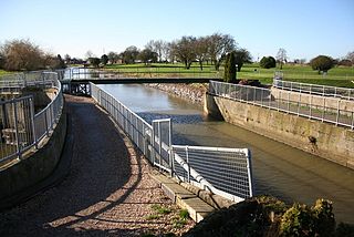
The South Forty-Foot Drain, also known as the Black Sluice Navigation, is the main channel for the land-drainage of the Black Sluice Level in the Lincolnshire Fens. It lies in eastern England between Guthram Gowt and the Black Sluice pumping station on The Haven, at Boston. The Drain has its origins in the 1630s, when the first scheme to make the Fen land available for agriculture was carried out by the Earl of Lindsey, and has been steadily improved since then. Water drained from the land entered The Haven by gravity at certain states of the tide until 1946, when the Black Sluice pumping station was commissioned.
The Car Dyke was, and to a large extent still is, an 85-mile (137 km) long ditch which runs along the western edge of the Fens in eastern England. It is generally accepted as being of Roman age and, for many centuries, to have been taken as marking the western edge of the Fens. There, the consensus begins to break down.

Bourne Eau is a short river which rises from an artesian spring in the town of Bourne in Lincolnshire, England, and flows in an easterly direction to join the River Glen at Tongue End. Within the town, it once powered three water mills, one of which is now a heritage centre. At Eastgate, it becomes much wider as it was navigable in the 18th and 19th centuries, and this was the location of the terminal basin. Below the town it is an embanked river, as its normal level is higher than that of the surrounding Fens. Navigation ceased in the 1860s and the river now forms an important part of the drainage system that enables the surrounding fen land to be used for agriculture.
The Deepings are a series of settlements close to the River Welland near the borders of southern Lincolnshire and north western Cambridgeshire in eastern England. Peterborough is about 8 miles to the south, Spalding about 10 miles to the north east and Stamford about 8 miles to the west.
Tiddy Mun was a legendary bog spirit in England, who was believed to have the ability to control the waters and mists of The Fens of South Lincolnshire, The Carrs of North Lincolnshire and fens of the Isle of Ely.

The Forty Foot or Forty Foot Drain is a name given to several of the principal channels in the drainage schemes of the Fens of Eastern England, the name being qualified when there is a need to distinguish between them. They are Vermuyden's Drain, South Forty Foot and North Forty Foot.

The Poitevin or Poitou is a French breed of draft horse. It is named for its area of origin, the former province of Poitou in west-central France, now a part of the region of Nouvelle-Aquitaine. It was formed in the seventeenth century when horses of Flemish or Dutch origin, brought to the area by engineers working to drain the Marais Poitevin, interbred with local horses. Although it has the size and conformation of a draft horse, the Poitevin has never been bred for draft abilities, and has been little used for draft work. Its principal traditional use was the production of mules. Poitevin mares were put to jacks of the large Baudet du Poitou breed of donkey; the resulting Poitevin mules were in demand for agricultural and other work in many parts of the world, including Russia and the United States. In the early twentieth century there were some 50,000 brood mares producing between 18,000 and 20,000 mules per year.
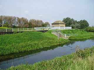
The Witham Navigable Drains are located in Lincolnshire, England, and are part of a much larger drainage system managed by the Witham Fourth District Internal Drainage Board. The Witham Fourth District comprises the East Fen and West Fen, to the north of Boston, which together cover an area of 97 square miles (250 km2). In total there are over 438 miles (705 km) of drainage ditches, of which under 60 miles (97 km) are navigable. Navigation is normally only possible in the summer months, as the drains are maintained at a lower level in winter, and are subject to sudden changes in level as a result of their primary drainage function, which can leave boats stranded. Access to the drains is from the River Witham at Anton's Gowt Lock.
Pode Hole is a village in South Holland, Lincolnshire, England. It is 2 miles (3.2 km) from Spalding and a similar distance from Bourne. The village lies at the confluence of several drainage channels, where two pumping stations discharge water into Vernatt's Drain from land in Deeping Fen to the South and West. Water from Pinchbeck South Fen to the North is also lifted into Vernatt's Drain. The village arose to service the pumping stations.
Guthram Gowt is a small settlement in the South Holland district of Lincolnshire, England. It is situated 5 miles (8 km) both east from Bourne and west from Spalding, and at a bend in the River Glen.

South Holland IDB is an English internal drainage board set up under the terms of the Land Drainage Act 1930. It has responsibility for the land drainage of 148.43 square miles (384.4 km2) of low-lying land in South Lincolnshire. It is unusual as its catchment area is the same as the area of the drainage district, and so it does not have to deal with water flowing into the area from surrounding higher ground. No major rivers flow through the area, although the district is bounded by the River Welland to the west and the River Nene to the east.
Adventurers were groups of English engineers and wealthy landowners, who funded large scale land drainage projects in the seventeenth century, in return for rights to some of the land reclaimed.
Sir Peregrine Bertie was a Jacobean soldier and landowner from Lincolnshire. He represented that county in Parliament in 1614, attended to local land improvements, and took part in several wars on the continent. He and his elder brother Lord Willoughby were frequently at odds with Lord Norreys.
Barthélemy Hervart or Herwart was a Huguenot banker. He saved the French monarchy on several occasions during the Fronde, the series of civil wars in France in the mid-17th century, by means of important loans, and during the period of the fall of Louis XIV's Superintendent of Finance Nicolas Fouquet.
References
- 1 2 3 4 5 6 7 Basil Morgan (2004). Bradley, Humphrey (fl. 1584–1625), designer of land drainage systems. Oxford Dictionary of National Biography (online edition). Oxford: Oxford University Press. doi:10.1093/ref:odnb/50333. (subscription required).
- ↑ Humphrey Bradley (1589). Discourse of Humphry Bradley, a Brabanter, concerning the fens in Norfolk, Huntingdon, Cambridge, Northampton, and Lincolnshire, Dec. 3, 1589. British Library, Lansdowne MS 60/34.
- ↑ H. C. Darby (2011 [1956]). The Draining of the Fens. Cambridge: Cambridge University Press. ISBN 9781107402980.
- 1 2 Lawrence Ernest Harris (1961). The Two Netherlanders: Humphrey Bradley and Cornelis Drebbel. Leiden: E.J. Brill.
- ↑ Louis Edouard Marie Hippolyte, comte de Dienne (1891). Histoire du desséchement des lacs et marais en France avant 1789 (in French). Paris: H. Champion.
| International | |
|---|---|
| National | |