Fairview Conservation Park is a protected area in the Australian state of South Australia located in the gazetted locality of Woolumbool about 17 kilometres (11 mi) north of Lucindale in the state's Limestone Coast region.

Kadina is a town on the Yorke Peninsula of the Australian state of South Australia, approximately 144 kilometres north-northwest of the state capital of Adelaide. The largest town of the Peninsula, Kadina is one of the three Copper Triangle towns famous for their shared copper mining history. The three towns are known as "Little Cornwall" for the significant number of immigrants from Cornwall who worked at the mines in the late 19th century.

Bute is a town in the Northern Yorke peninsula of South Australia, approximately 40 kilometres (25 mi) east of Wallaroo and 24 kilometres west of Snowtown. It was proclaimed as a town in 1884 and named after the Isle of Bute, in the Firth of Clyde, Scotland. It was the original site of the Yorke Peninsula Field Days in 1895; they are now held outside Paskeville.
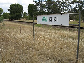
Ki Ki is a small town in South Australia. It is on the Dukes Highway (A8) adjacent to the Adelaide-Melbourne railway, the main links between Adelaide and Melbourne. The town is the primary settlement for the Hundred of Livingston.
Dutton is a settlement in South Australia. The small township lies approximately six kilometres (3.7 mi) north of Truro on the Eudunda Road. It was first laid out in 1866 and lots were advertised for sale in the German-language newspaper Südaustralische Zeitung.

Kongorong is a locality in the Australian state of South Australia located southwest of Mount Gambier. It has an Australian rules football team and netball team. Kongorong Primary School had 61 students in 2010.
Giles Conservation Park is a protected area in the Australian state of South Australia located approximately 10 km (6.2 mi) east of the state capital of Adelaide. It was declared in 2007 and has an area of 109 ha. Previously, the land was the eastern portion of the Horsnell Gully Conservation Park. It was named after the family of Charles Giles who is reported as being a pioneer in the fields of horticulture and floriculture in South Australia.
Hart is a locality in the Mid North region of South Australia. The boundaries were formalised in January 2000 for the long established name for the area. There was a railway siding at Hart on the Gladstone railway line. The major industry in the area is cereal crop growing.
Desert Camp Conservation Reserve is a protected area in the Australian state of South Australia located in the state's Limestone Coast in the gazetted locality of Marcollat about 44 kilometres (27 mi) south of the town centre in Keith. It is classified as an IUCN Category VI protected area.
Desert Camp Conservation Park is a protected area in the Australian state of South Australia located in the state's Limestone Coast region in the gazetted locality of Marcollat about 44 kilometres (27 mi) south of the town centre in Keith.
Mullinger Swamp Conservation Park is a protected area in the Australian state of South Australia located in the state's south-east in the gazetted locality of Kybybolite on the border with the state of Victoria about 25 kilometres (16 mi) north-east of Naracoorte.
Mount Scott Conservation Park is a protected area in the Australian state of South Australia located in the gazetted locality of Blackford about 23 kilometres (14 mi) east of Kingston SE in the state's Limestone Coast region.
Pine Hill Soak Conservation Park is a protected area in the Australian state of South Australia located in the state's Limestone Coast in the gazetted locality of Bangham about 30 kilometres (19 mi) south of the town centre in Bordertown.
Lindley is a locality in Mid Murray Council in the Mid North of South Australia, north of Morgan, South Australia. Its boundaries are coincident with the cadastral Hundred of Lindley in the County of Burra. The Goyder Highway traverses the southwestern corner of the locality.
Clements Gap Conservation Park is a protected area located in the Mid North of South Australia about 15 kilometres (9.3 mi) west of Redhill, 20 kilometres (12 mi) north east of Port Broughton and 42 metres above sea level. The park preserves an area of natural bushland and the built remnants of a small historic agricultural township, Clements Gap, about 12 kilometres (7.5 mi) east of the Spencer Gulf coast. Maintained by the South Australian Department of Environment, Water and Natural Resources (DEWNR), the park is classified as an IUCN Category III Natural Monument or Feature. The park is named for the surrounding farming locality of Clements Gap, a reference to the co-located pass through the Barunga Range. The Clements Gap pass in turn is thought to be named after a shepherd in the area prior to 1880, per research by local historian Rodney Cockburn.
Furner Conservation Park is a protected area located in the Australian state of South Australia in the locality of Furner about 310 kilometres (190 mi) south-east of the state capital of Adelaide and about 27 kilometres (17 mi) north west of the municipal seat of Millicent.
Glen Roy Conservation Park is a protected area located in the Australian state of South Australia in the locality of Glenroy about 323 kilometres (201 mi) south-east of the state capital of Adelaide and about 25 kilometres (16 mi) north of the town of Penola.
Nixon-Skinner Conservation Park is a protected area located in the Australian state of South Australia in the locality of Myponga about 55 kilometres (34 mi) south of the state capital of Adelaide and about 3.5 kilometres (2.2 mi) south-west of the town of Myponga.
Jip Jip Conservation Park is a protected area in the Australian state of South Australia located in the state’s south-east in the gazetted locality of Marcollat about 223 kilometres (139 mi) south-east of the state capital of Adelaide and about 50 kilometres (31 mi) north-east of the municipal seat of Kingston SE.

The District Council of Coonalpyn Downs was a local government area in the Australian state of South Australia that existed from 1957 to 1997 on land in the state’s south-east.
