Related Research Articles

Hastings County is located in the province of Ontario, Canada. Geographically, it is located on the border of Eastern Ontario and Central Ontario. Hastings County is the second-largest county in Ontario, after Renfrew County, and its county seat is Belleville, which is independent of Hastings County. Hastings County has trademarked the moniker "Cheese Capital of Canada".
Tweed is a municipality located in central-eastern Ontario, Canada, in Hastings County.

The Municipality of Centre Hastings is a township in Eastern Ontario, Canada, in Hastings County. It was formed on January 1, 1998, through the amalgamation of Huntingdon Township with the Village of Madoc.
The Moira River is a river in Hastings County in eastern Ontario, Canada. It travels from its source in the centre of the county to the Bay of Quinte at the county seat Belleville.
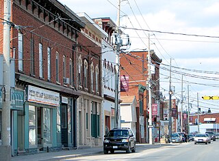
Tweed, Ontario is a community on Stoco Lake and the only urban centre in the Municipality of Tweed in Hastings County, central-eastern Ontario, Canada. Tweed has a population of 1,701 according to the 2016 Canada Census. The principal thoroughfare through Tweed is Highway 37.
Limerick is a small township in Hastings County, Ontario, Canada, near Limerick Lake. It is located 80 kilometres (50 mi) north of Belleville between Madoc and Bancroft and served by Ontario Highway 62 and Township Road 620. The Township is bordered by the Town of Bancroft, Township of Wollaston and the joined Townships of Tudor and Cashel. The township is heavily forested, as is the shoreline of the Limerick Lake, the main industry in the township being forestry and logging. The population of Limerick Township is approx. 300 full-year residents, and another 1000 seasonal residents.
King's Highway 37, commonly referred to as Highway 37, is a provincially maintained highway in the Canadian province of Ontario. It begins at Highway 401 in Belleville and travels 44.2 km (27.5 mi) north to Highway 7 in Actinolite. The route once continued south through Belleville to Highway 62, but was truncated in 1998. Prior to the re-routing, Highway 37 was 47.2 km (29.3 mi) long.
Seymour is a former incorporated township and now a geographic township located in Northumberland County, Ontario, Canada. It is currently part of the Municipality of Trent Hills.
Percy, Ontario was a former incorporated township and now a geographic township located in Northumberland County, Ontario, Canada. It is currently part of the Municipality of Trent Hills.
Tudor and Cashel is a township in the Canadian province of Ontario, located in Hastings County.

Queensborough is an unincorporated community in the municipality of Tweed, Hastings County, in Central Ontario, Canada. It is located north of Ontario Highway 7 on the Black River, about 20 kilometres (12 mi) north-west of the village of Tweed and 15 kilometres (9.3 mi) north-east of the town of Madoc.

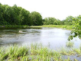
Stoco Lake is a lake in the Lake Ontario drainage basin in Tweed, Hastings County, Ontario, Canada.
The Clare River is a river that is part of the Moira River system in the Lake Ontario drainage basin in Hastings and Lennox and Addington Counties, Ontario, Canada.
Elzevir Lake is a lake in the Moira River and Lake Ontario drainage basins in Tweed, Hastings County, Ontario, Canada.
Grimsthorpe Lake is a lake in the Moira River and Lake Ontario drainage basins that straddles the border between Tweed, Hastings County and Addington Highlands, Lennox and Addington County in Ontario, Canada.
Deerock Lake is a lake in the Moira River in Tweed, Hastings County and Addington Highlands, Lennox and Addington County in Ontario, Canada.
Sulphide Creek is a creek in the Moira River and Lake Ontario drainage basins in Tweed, Hastings County and Addington Highlands, Lennox and Addington County in Ontario, Canada.
Otter Creek is the name of a settlement in the municipality of Tweed, Hastings County, Ontario, Canada. It lies 3 kilometres (1.9 mi) east of the community of Sulphide and 10 kilometres (6 mi) northeast of the village of Tweed. Otter Creek, a tributary of the Clare River in the Moira River drainage basin, flows through the community.
Cosy Cove is a settlement on Stoco Lake in the municipality of Tweed, Hastings County, Ontario, Canada, about 4 kilometres (2.5 mi) southwest of the community of Sulphide and 2.5 kilometres (1.6 mi) east of the village of Tweed. Sulphide Creek, a tributary of the Moira River, reaches its mouth at Stoco Lake in the community.
Bogart is a settlement in the municipality of Tweed, Hastings County, Ontario, Canada, about 2.3 kilometres (1.4 mi) south of the community of Sulphide and 5.3 kilometres (3.3 mi) east of the village of Tweed. The Clare River, a tributary of the Moira River, flows through the community.
References
- "Hungerford". Geographical Names Data Base . Natural Resources Canada . Retrieved 2010-03-16.
- "Toporama - Topographic Map Sheet 31C11". Atlas of Canada . Natural Resources Canada. Archived from the original on August 31, 2010. Retrieved 2010-03-16.
- "Pioneers of Hastings County". RootsWeb . Retrieved 2019-12-28.
Coordinates: 44°32′16″N77°11′54″W / 44.53778°N 77.19833°W
| | This Eastern Ontario geographical article is a stub. You can help Wikipedia by expanding it. |