
Central America is a region containing seven countries that connects the two continents of North America and South America.

Central America is a region containing seven countries that connects the two continents of North America and South America.

Belize is a low-lying country in Central America, with a population of about 383,000 people. Throughout history, Belize has been impacted by hundreds of tropical cyclones. The most recent hurricane to impact Belize was Hurricane Nana (2020).
Since records began in 1851, only two hurricanes have had Category 5 hurricane strength and have hit or hit close to Belize: Hurricane Janet in 1955 and Hurricane Dean in 2007.

Costa Rica (English: Rich Coast), officially the Republic of Costa Rica (Spanish : República de Costa Rica), is a country in Central America, bordered by Nicaragua to the north, the Caribbean Sea to the northeast, Panama to the southeast, the Pacific Ocean to the southwest, and Ecuador to the south of Cocos Island. It has a population of around 5 million [1] [2] in a land area of 51,060 square kilometers (19,714 square miles). Hurricanes are uncommon in this country; only eighteen have been recorded in history.
Climatologically, the hurricanes that impact Costa Rica mostly form in October and November. However, most of the hurricanes that hit the country were deadly and destructive, such as Hurricane Nate in 2017. Instituto Meteorológico Nacional (IMN) is the national meteorological agency of Costa Rica. [3]
El Salvador is rarely affected by hurricanes, though Tropical Storm Agatha caused heavy rains and flooding in 2010. [4]

Honduras ( /hɒnˈdjʊərəs,-ˈdʊər-/ , /-æs/ ; [5] Spanish: [onˈduɾas] ), officially the Republic of Honduras (Spanish : República de Honduras), is a country in Central America. To the north of Honduras are Guatemala and Belize, to the south is Nicaragua, to the west is El Salvador, and to the east is the Caribbean Sea.

Nicaragua, officially the Republic of Nicaragua (Spanish : ), is the largest country in the Central American isthmus, bordered by Honduras to the northwest, the Caribbean Sea to the east, Costa Rica to the south, and the Pacific Ocean to the southwest. Tropical cyclones are common in the country, with an average of one storm a year. The coast is especially subject to destructive tropical storms and hurricanes, particularly from July through October. The high winds and floods accompanying these storms often cause considerable destruction of property. Hurricanes or heavy rains in the central highlands where agriculture is prevalent have destroyed much of the natural vegetation, causing considerable crop damage and soil erosion. One of the deadliest hurricanes to hit Nicaragua was Hurricane Mitch in 1998, which killed thousands.

Panama (Spanish: Panamá), officially the Republic of Panama (Spanish: República de Panamá), is a transcontinental country in Central America and South America, bordered by Costa Rica to the west, Colombia to the southeast, the Caribbean Sea to the north, and the Pacific Ocean to the south. Hurricanes are not common in Panama, as the country is outside of the Main Development Region.

Central America is a subregion of North America. Its political boundaries are defined as bordering Mexico to the north, Colombia to the south, the Caribbean Sea to the east, and the Pacific Ocean to the west. Central America is usually defined as consisting of seven countries: Belize, Costa Rica, El Salvador, Guatemala, Honduras, Nicaragua, and Panama. Within Central America is the Mesoamerican biodiversity hotspot, which extends from northern Guatemala to central Panama. Due to the presence of several active geologic faults and the Central America Volcanic Arc, there is a high amount of seismic activity in the region, such as volcanic eruptions and earthquakes, which has resulted in death, injury, and property damage.
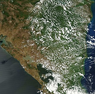
Nicaragua is a country in Central America, bordering both the Caribbean Sea and the North Pacific Ocean, between Costa Rica and Honduras. Nicaragua is the largest country in Central America in square kilometers.

Hurricane Mitch was the second-deadliest Atlantic hurricane on record. Mitch caused 11,374 fatalities in Central America in 1998, including approximately 7,000 in Honduras and 3,800 in Nicaragua due to cataclysmic flooding from the slow motion of the storm. It was the deadliest hurricane in Central American history, surpassing Hurricane Fifi–Orlene, which killed slightly fewer people in that area in 1974. Mitch was the deadliest Atlantic hurricane in the satellite era, and the second-deadliest on record in the Atlantic, only behind the Great Hurricane of 1780 which killed at least 22,000 people.

Hurricane Michelle was the fifth costliest tropical cyclone in Cuban history and the strongest hurricane of the 2001 Atlantic hurricane season. The thirteenth named storm and seventh hurricane that year, Michelle developed from a tropical wave that had traversed into the western Caribbean Sea on October 29; the wave had initially moved off the coast of Africa 13 days prior. In its early developmental stages, the depression meandered over Nicaragua, later paralleling the Mosquito Coast before intensifying into tropical storm intensity on November 1; Michelle was upgraded to hurricane strength the following day. Shortly after, rapid intensification ensued within favorable conditions, with the storm's central barometric pressure dropping 51 mbar in 29 hours. After a slight fluctuation in strength, Michelle reached its peak intensity as a Category 4 hurricane with winds of 140 mph (230 km/h) and a minimum pressure of 933 mbar. This tied Michelle with 1999's Lenny as the fourth most powerful November hurricane on record in the Atlantic Basin, behind only the 1932 Cuba hurricane and 2020 Hurricanes Iota and Eta. At roughly the same time, the hurricane began to accelerate northeastward; this brought the intense hurricane to a Cuban landfall within the Bay of Pigs later that day. Crossing over the island, Michelle was weakened significantly, and was only a Category 1 hurricane upon reentry into the Atlantic Ocean. The hurricane later transitioned into an extratropical cyclone over The Bahamas on November 5, before being absorbed by a cold front the following day.
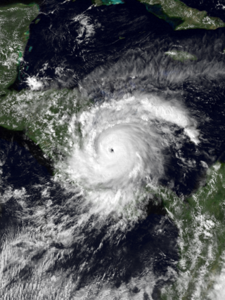
Hurricane Joan was a long lived and powerful tropical cyclone that caused death and destruction in over a dozen countries in the Caribbean and Central America. Moving on a due west course for nearly two weeks in October 1988, Hurricane Joan caused widespread flooding and over 200 deaths after moving into Central America. Widespread suffering and economic crises were exacerbated by Joan, primarily across Nicaragua, as heavy rains and high winds impacted those near the hurricane's path.
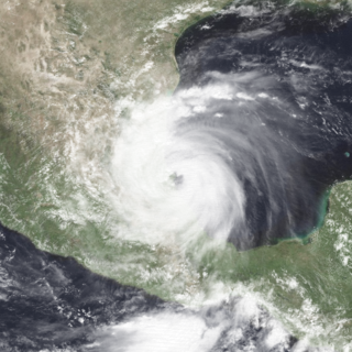
Hurricane Gert was a large tropical cyclone that caused extensive flooding and mudslides throughout Central America and Mexico in September 1993. The seventh named storm and third hurricane of the annual hurricane season, Gert originated as a tropical depression from a tropical wave over the southwestern Caribbean Sea on September 14. The next day, the cyclone briefly attained tropical storm strength before moving ashore in Nicaragua and proceeding through Honduras. It reorganized into a tropical storm over the Gulf of Honduras on September 17, but weakened back to a depression upon crossing the Yucatán Peninsula. Once over the warm waters of the Bay of Campeche, Gert quickly strengthened into a Category 2 hurricane by September 20. The hurricane made a final landfall on the Gulf Coast of Mexico near Tuxpan, Veracruz, with peak winds of 100 mph (160 km/h). The rugged terrain disrupted the cyclone's structure; Gert entered the Pacific Ocean as a depression near the state of Nayarit on September 21, where it briefly redeveloped a few strong thunderstorms before dissipating at sea five days later.
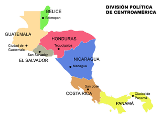
Central America is a subregion of the Americas formed by six Latin American countries and one (officially) Anglo-American country, Belize. As an isthmus it connects South America with the remainder of mainland North America, and comprises the following countries : Belize, Guatemala, Honduras, El Salvador, Nicaragua, Costa Rica, and Panama.
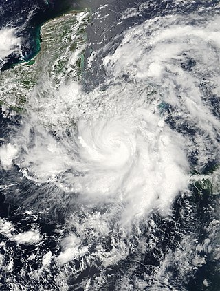
Tropical Storm Alma of the 2008 Pacific hurricane season was the easternmost forming Pacific tropical cyclone on record. It formed within the monsoon trough just off the coast of Costa Rica on May 29. Initially forecast to remain a weak tropical storm, the cyclone rapidly strengthened and developed an eye, before making landfall on May 29 in Nicaragua, near León, with peak winds of 65 mph (105 km/h). Alma degenerated into a remnant low on May 30, before merging with another approaching tropical wave in the Gulf of Honduras shortly afterward, which became Tropical Storm Arthur on the next day. Alma was the first tropical storm on record to strike the Pacific coast of Nicaragua. In Costa Rica, heavy rainfall caused flooding and landslides, killing two and causing $35 million (USD) in damage. Three people were killed in Nicaragua, one from drowning and two others from electrocution. Five others died in Honduras from an aviation accident likely related to the storm and one other was swept away in floodwaters.

The October 2008 Central America floods were caused by a series of low-pressure areas including Tropical Depression Sixteen, a short-lived tropical cyclone in the 2008 Atlantic hurricane season that made landfall in Honduras. Heavy rainfall began in early October 2008 while a tropical wave passed through the region. On October 14, Tropical Depression Sixteen formed just off the northeast coast of Honduras, and at the same time a low-pressure system was on the Pacific coast. Both systems increased rainfall across the region, although the depression dropped heavy rainfall close to its center when it moved ashore on October 15. Although Tropical Depression Sixteen quickly dissipated over land, its remnants persisted for several days. Another low-pressure area interacted with a cold front on October 21, adding to the rainfall in the region.

This is an index of Central America-related articles. This index defines Central America as the seven nations of Belize, Costa Rica, El Salvador, Guatemala, Honduras, Nicaragua, and Panama.

Hurricane Beta was a compact and intense tropical cyclone that impacted the southwestern Caribbean in late October 2005. Beta was the twenty-fourth tropical storm, fourteenth hurricane, and seventh and final major hurricane of the record-breaking 2005 Atlantic hurricane season. On October 21, a developing tropical wave entered the eastern Caribbean Sea and spawned Tropical Storm Alpha the following day. As the wave entered the southwestern Caribbean, convection redeveloped and on October 26, the system spawned another low-pressure area which developed into Tropical Depression Twenty-six. The depression intensified into a tropical storm the next morning and was named Beta. By the morning of October 28, the storm intensified into a hurricane, the fourteenth of the season. Beta underwent rapid intensification for several hours to attain its peak intensity with winds of 115 mph (185 km/h) on October 30. The storm began to deteriorate before landfall, weakening to Category 2 status as it crossed the Nicaraguan coastline. Rapid weakening followed landfall, and the storm dissipated early the next morning.

Tropical Storm Matthew was a weak but deadly and destructive tropical cyclone which made landfall in Central America during the 2010 Atlantic hurricane season. The fifteenth tropical cyclone and thirteenth named storm of the year, Matthew formed on September 23 and lost its tropical characteristics in the morning of September 26. However, its remnants continued to produce life-threatening rain over parts of Central America as it dissipated.

Tropical Storm Barry was a weak and short-lived tropical cyclone that brought heavy rains to parts of Central America and Mexico in June 2013. Barry originated from a tropical wave that developed in the southern Caribbean Sea. The wave tracked northwestward and began to develop in marginally favorable conditions. On June 17, the disturbance was upgraded to Tropical Depression Two by the National Hurricane Center. Due to its close proximity to land, the system failed to intensify before crossing the southern Yucatán Peninsula. The depression emerged over the Bay of Campeche late on June 18 and became increasingly organized. During the afternoon of June 19, data from Hurricane Hunters revealed the system had intensified into a tropical storm. The newly named Barry attained peak winds of 45 mph (75 km/h) before making landfall in Veracruz, Mexico on June 20. Once onshore, the storm quickly weakened and degenerated into a remnant low that night.

Hurricane Otto was a strong late-season tropical cyclone that impacted parts of Central America in November 2016. It was the first Atlantic hurricane since Cesar–Douglas in 1996 to survive the crossover from the Atlantic Ocean to the Pacific Ocean. Forming late on November 20 in the southwestern Caribbean Sea, Otto was the fifteenth and final named storm, seventh hurricane and fourth major hurricane of the 2016 Atlantic hurricane season. It quickly intensified into a strong tropical storm the next day, and on November 23–24, rapidly strengthened into a Category 3 hurricane, the first in the month of November since Hurricane Paloma in 2008, and the latest date an Atlantic hurricane attained such intensity on record. Otto made landfall in Nicaragua at peak intensity on November 24, thus becoming the latest hurricane to make landfall in the Atlantic basin since 1851 when records began. Traveling along the Nicaragua–Costa Rica border, the system rapidly weakened to a tropical storm before emerging over the eastern Pacific Ocean, becoming the final storm of the 2016 Pacific hurricane season as well. Hostile environmental conditions inhibited reorganization, and Otto subsequently degenerated into an elongated trough on November 26.

Hurricane Nate was an Atlantic hurricane which was the costliest natural disaster in Costa Rican history. An unusually fast-moving tropical cyclone, it caused severe flooding in Central America, leading to widespread destruction and casualties, during early October 2017, before making landfall on the US Gulf Coast. The fourteenth named storm and ninth hurricane of the extremely active 2017 Atlantic hurricane season, Nate originated from a broad area of low pressure over the southwestern Caribbean on October 3. The disturbance moved northwest, organizing into a tropical depression the next day and attaining tropical storm intensity early on October 5. The storm made landfall in Nicaragua that same day and continued into Honduras with little change in strength. Nate began steady intensification over the warm waters of the northwestern Caribbean Sea shortly thereafter. It attained hurricane strength while moving through the Yucatán Channel early on October 7, attaining peak winds of 90 mph (150 km/h) in the central Gulf of Mexico later that day. Early on the next day, Nate made landfall near the mouth of the Mississippi River in Louisiana. After crossing the marshland of the Mississippi Delta, it made its second U.S. landfall near Biloxi, Mississippi early on October 8, causing a storm surge to flood the ground floors of coastal casinos and buildings, as well as causing rip currents, hurricane-force winds, and beach erosion.

Costa Rica, officially the Republic of Costa Rica, is a country in Central America, bordered by Nicaragua to the north, the Caribbean to the northeast, Panama to the southeast, the Pacific Ocean to the southwest, and Ecuador to the south of Cocos Island. It has a population of around 5 million in a land area of 51,060 square kilometers. Hurricanes are uncommon in the country, as only eighteen have been recorded in history.

Belize, formerly known as British Honduras, is a Caribbean country located on the northeastern coast of Central America. Belize is bordered on the northwest by Mexico, on the east by the Caribbean Sea, and on the south and west by Guatemala. It has an area of 22,970 square kilometres (8,867 sq mi) and a population of 408,487 (2019). Its mainland is about 290 km (180 mi) long and 110 km (68 mi) wide. It has the lowest population and population density in Central America.

Nicaragua, officially the Republic of Nicaragua, is the largest country in the Central American isthmus, bordered by Honduras to the northwest, the Caribbean to the east, Costa Rica to the south, and the Pacific Ocean to the southwest. Tropical cyclones are common in the country, with an average of one storm a year. The coast is especially subject to destructive tropical storms and hurricanes, particularly from July through October. The high winds and floods, accompanying these storms often cause considerable destruction of property. Hurricanes or heavy rains in the central highlands where agriculture has destroyed much of the natural vegetation also cause considerable crop damage and soil erosion. One of the deadliest hurricanes to hit Nicaragua has been Hurricane Mitch in 1998, in which the storm killed thousands in the country.

Hurricane Eta was a deadly and erratic Category 4 hurricane that devastated parts of Central America in early November 2020. The record-tying twenty-eighth named storm, thirteenth hurricane, and sixth major hurricane of the extremely-active 2020 Atlantic hurricane season, Eta originated from a vigorous tropical wave in the eastern Caribbean Sea on October 31. The system rapidly organized as it progressed west, with the cyclone ultimately becoming a Category 4 hurricane on November 3. With a peak intensity of 150 mph (240 km/h) and 922 millibars, it was the third most intense November Atlantic hurricane on record, behind the 1932 Cuba hurricane and Hurricane Iota, the latter of which formed just two weeks later in the same area. Some weakening took place as the system made landfall near Puerto Cabezas, Nicaragua, late that same day. Eta rapidly weakened to a tropical depression and briefly degenerated to a remnant low as it meandered across Central America for two days, before regenerating into a tropical depression and moving north over water. The storm later reorganized over the Caribbean as it accelerated toward Cuba on November 7, making a second landfall on the next day. Over the next five days, the system moved erratically, making a third landfall in the Florida Keys, on November 9, before slowing down and making a counterclockwise loop in the southern Gulf of Mexico, just off the coast of Cuba, with the storm's intensity fluctuating along the way. After briefly regaining hurricane strength on November 11, the system weakened back to a tropical storm once more, before making a fourth landfall on Florida on the next day, and proceeding to accelerate northeastward. Eta subsequently became extratropical on November 13, before dissipating off the coast of the Eastern United States on the next day.

Hurricane Julia was a deadly tropical cyclone that caused significant impacts in Central America as a Category 1 hurricane in October 2022. The tenth named storm and fifth hurricane of the 2022 Atlantic hurricane season, Julia formed from a tropical wave over the southern Caribbean Sea on October 7, just off the coast of South America. Only one storm on record, Tropical Storm Bret in 1993, has tracked further south over South America.