
Daniel Boone was an American pioneer, explorer, woodsman, and frontiersman, whose frontier exploits made him one of the first folk heroes of the United States. Boone is most famous for his exploration and settlement of what is now Kentucky. It was still considered part of Virginia but was on the western side of the Appalachian Mountains from most European-American settlements. As a young adult, Boone supplemented his farm income by hunting and trapping game, and selling their pelts in the fur market. Through this occupational interest, Boone first learned the easy routes to the area. Despite some resistance from American Indian tribes such as the Shawnee, in 1775, Boone blazed his Wilderness Road from North Carolina and Tennessee through Cumberland Gap in the Cumberland Mountains into Kentucky. There, he founded the village of Boonesborough, Kentucky, one of the first American settlements west of the Appalachians. Before the end of the 18th century, more than 200,000 Americans migrated to Kentucky/Virginia by following the route marked by Boone.

Owsley County is a county located in the Eastern Coalfield region of the U.S. state of Kentucky. As of the 2010 census, the population was 4,755, making it the second-least populous county in Kentucky. The county seat is Booneville. The county was organized on January 23, 1843, from Clay, Estill, and Breathitt counties and named for William Owsley (1782–1862), the judge of the Kentucky Court of Appeals and Governor of Kentucky (1844–48).

Harrison County is located in the far southern part of the U.S. state of Indiana along the Ohio River. The county was officially established in 1808. As of the 2010 census, the county's population was 39,364, an increase of 6.6% from 2000. The county seat is Corydon, the former capital of Indiana.

Boone County is a county located in the U.S. state of Illinois. As of the 2010 census, the population was 54,165. Its county seat is Belvidere.
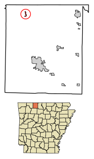
Omaha is a town in Boone County, Arkansas, United States. As of the 2010 census the population stood at 157. It is a rural community located approximately 10 miles from Branson, Missouri and 15 miles from Harrison. The town is part of the Harrison Micropolitan Statistical Area.

Richmond is a home rule-class city in and the county seat of Madison County, Kentucky, United States. It is named after Richmond, Virginia, and is the home of Eastern Kentucky University. The population was 33,533 in 2015. Richmond is the third-largest city in the Bluegrass region and the state's sixth-largest city. Richmond serves as the center for work and shopping for south-central Kentucky. Richmond is the principal city of the Richmond–Berea Micropolitan Statistical Area, which includes all of Madison and Rockcastle counties.

Walton is a home rule-class city in Boone and Kenton counties in the U.S. state of Kentucky. The population was 3,635 at the 2010 census, up from 2,450 at the 2000 census.

Hudson's, or The J.L. Hudson Company, was a retail department store chain based in Detroit, Michigan. Hudson's flagship store, on Woodward Avenue in Downtown Detroit, was the tallest department store in the world in 1961, and, at one time, claimed to be the second-largest department store, after Macy's, in the United States, by square footage.

Edwardsburgh/Cardinal is a township in the United Counties of Leeds and Grenville of eastern Ontario, Canada. Edwardsburgh township was first surveyed in 1783, and incorporated in 1850. The township was part of the historical Grenville County before it merged with Leeds County to form the United Counties in the 19th century.
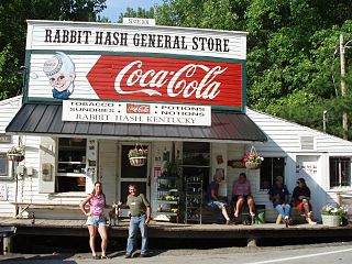
Rabbit Hash is an unincorporated community and census-designated place (CDP) in Boone County, Kentucky, United States, with a population of 315. It is listed on the National Register of Historic Places. The town is notable for its name, its string of canine mayors, and its historic general store which was destroyed by fire in 2015. A new structure was later built in its place.

Petersburg is a rural unincorporated community and census-designated place (CDP) in Boone County, Kentucky, United States. As of the 2010 census Petersburg, along with its surrounding areas that use the 41080 zip code, had a population of 620.

Hamilton is an unincorporated community in Boone County, Kentucky, United States. It is situated at Latitude 38.88333, Longitude -84.78167, in the southern part of the county on the Ohio River; it is about a mile north of the mouth of Big Bone Creek. It was established in 1835, being incorporated by the Kentucky Legislature as the Town of Landing. The plat laid out by Joel Hamilton and George McGlasson. The original trustees were: William Winston, Jr., George McGlasson, Joel Hamilton, Henry L. Rose, James Dukan. The same year the Legislature provided a Constable for the town.

Lithia Motors, Inc. is an American nationwide automotive retailer headquartered in Medford, Oregon. It is the fourth largest automotive retailer in the United States. In 2015, Lithia Motors broke into the Fortune 500 list at #482, making it one of only three Oregon-based companies in the Fortune 500. This followed a year that saw the acquisition of the DCH Auto Group, one of the 10 largest dealer groups in the country, with 27 dealerships, before being purchased by Lithia Motors. In 2016, Lithia climbed to #346 and that same year made the Fortune 500 List of Top Ten Companies with the biggest jump in rank on the Fortune 500. As of 2018, Lithia is ranked #294 on the Fortune 500. Lithia employs more than 14,150 people in stores across the nation including Alaska and Hawaii. Lithia operates 180 stores in 18 states.

Harrison Township is one of twelve townships in Harrison County, Indiana, United States. As of the 2010 census, its population was 12,484 and it contained 5,282 housing units. Corydon, the county seat of Harrison County, is in Harrison Township.
Athens is a small unincorporated village in the rural services area of Lexington-Fayette Urban County to the east of Interstate 75 in Kentucky in the United States. First settled in 1786 as the community of Cross Plains, the town was chartered as Athens in 1826 and had its own post office from that time until 1906. The current commercial center was reduced to its present size by a series of fires in the mid-19th century.

Verona is an unincorporated community and census-designated place (CDP) in Boone County, Kentucky, United States. The population was 1,455 at the 2010 census.
U.S. Route 27 (US 27) in Kentucky runs 190.785 miles (307.039 km) from the Tennessee border to the Ohio border at Cincinnati. It crosses into the state in the Lake Cumberland area, passing near or through many small towns, including Somerset, Stanford, and Nicholasville. The road then passes straight through the heart of Lexington, including past the University of Kentucky (UK) and Transylvania University. North of Lexington it passes through Cynthiana and Falmouth before entering Campbell County and passing through many Northern Kentucky suburbs before ending at the Ohio state line on the Taylor Southgate Bridge in Cincinnati.
Beaverlick is an unincorporated community in Boone County, Kentucky, United States. Beaverlick is located along U.S. Route 42 and U.S. Route 127 4.5 miles (7.2 km) west of Walton. The community was established as a fur trading site between 1780 and 1820. The community was founded sometime in the early 1800s. A post office was established at Beaver Lick in 1854 with John Tucker its postmaster. The post office closed in 1944.
Sugartit is a rural community in Boone County, Kentucky, United States. It was located at the intersection of U.S. Route 42 and Kentucky Route 237 between the cities of Florence and Union. Sugartit has been noted for its unusual place name.
Roundhill is an unincorporated community in Butler County, Kentucky, United States, situated on Butler County's eastern boundary with Edmonson County.


