Iganga

Last updated
Iganga
Weather in Nkono Iganga District.jpg
Uganda location map.svg
Red pog.svg
Iganga
Location in Uganda
Coordinates: 00°36′54″N33°29′06″E / 0.61500°N 33.48500°E / 0.61500; 33.48500
Country Flag of Uganda.svg Uganda
Region Eastern Region of Uganda
Sub-region Busoga sub-region
District Iganga District
Elevation
3,670 ft (1,120 m)
Population
 (2014 Census)
  Total53,870 [1]
Website igangamc.go.ug

Iganga is a town in the Eastern Region of Uganda. It is the main municipal, administrative, and commercial center of Iganga District. [2]

Contents

Location

Iganga is located in Uganda's Busoga sub-region. It lies approximately 40 kilometres (25 mi) northeast of the city of Jinja on the highway between Jinja and Tororo. [3]

This is approximately 108 kilometres (67 mi), by road, southwest of Mbale, the largest city in Uganda's Eastern Region. [4] The coordinates of the town of Iganga are:0°36'54.0"N, 33°29'06.0"E (Latitude:0.6150; Longitude:33.4850). [5]

Overview

Points of interest in the town include the DevelopNet Iganga Project, which houses an Internet cafe and a community center for the Iganga District NGO/CBO Forum. International Hand Iganga is a non-governmental organization operating in the area supporting education and community development. Iganga town has several Internet cafes, guest houses, and a bustling market in the center of town adjacent to the taxi park. [2] The town also has religious buildings like churches and mosques.

Transport

Iganga is served by a station on the Uganda Railways. The highway from the city of Jinja passes through Iganga, continuing on to Bugiri and Tororo, as the Jinja–Iganga–Bugiri–Tororo Road. From there it continues to the international border with Kenya at Malaba, approximately 104 kilometres (65 mi) east of Iganga. [6]

Population

In 2002, the national census estimated Iganga's population at 39,500. In 2010, the Uganda Bureau of Statistics (UBOS) estimated the population at 51,800. In 2011, UBOS estimated the mid-year population of Iganga at 53,700. [7] In 2014, the national population census put Iganga's population at 53,870. [1]

In 2015, the population of the town was estimated at 56,500. In 2020, the mid-year population of Iganga Town was projected at 65,500. The population grew at an average annual rate of 3.0 percent, between 2015 and 2020. [8]

Historical population
YearPop.±%
200239,500    
201051,800+31.1%
201153,700+3.7%
201453,870+0.3%
201556,500+4.9%
202065,500+15.9%
source: [1] [7] [8]

Health

Iganga General Hospital also known as Nakavule Hospital, serves the residents of the municipality of Iganga, as well as the rest of the district. [9] [10]

The hospital was rated to be a leading performer of general hospitals in Uganda financially, though its facilities and infrastructure are in need of updates. [11] The hospital was renovated as part of a seven hospital renovation project by the Ugandan government in November 2015. [12]

Efforts have been made to establish emergency medical services in Iganga, most notably with the development of a lay first responder program in 2016 by international collaborators from Washington University in St. Louis, LFR International and the Uganda Red Cross Society. [13] [14]

Points of interest

The following points of interest lie within or near Iganga: [15]

1. Iganga District Administration headquarters

2. Iganga Town Council offices

3. Busoga University, located 1 mile (1.6 km) west of Iganga between Iganga and Jinja

4. Iganga General Hospital, a 120-bed public hospital funded by the Uganda Ministry of Health

5. Iganga Railway Station

6. Iganga central market. [15]

Notable Person

See also

Related Research Articles

<span class="mw-page-title-main">Bugiri District</span> District in Eastern Uganda, Uganda

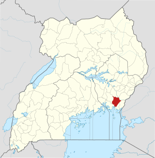
Bugiri District is a district in Eastern Uganda. Like most other Ugandan districts, it is named after its 'chief town', Bugiri, where the district headquarters are located.

<span class="mw-page-title-main">Tororo</span> Place in Eastern Region of Uganda, Uganda

Tororo is a town in the Eastern Region of Uganda. It is the main municipal, administrative, and commercial center of Tororo District.

<span class="mw-page-title-main">Mbale</span> Place in Eastern Uganda, Uganda

Mbale is a city in the Eastern Region of Uganda. It is the main municipal, administrative, and commercial center of Mbale District and the surrounding sub-region.

Budaka is a town in the Eastern Region of Uganda. It is the chief town of Budaka District, and the district headquarters are located there.

Bugiri is a town in the Eastern Region of Uganda. It is the chief town of Bugiri District, and the district headquarters are located there. The town was elevated to Municipal Council status in 2019.

Kamuli is a town in the Eastern Region of Uganda. It is the main municipal, administrative, and commercial centre of Kamuli District, and the district headquarters are located there. The district is named after the town.

Mayuge is a town in the Eastern Region of Uganda. It is the location of the headquarters of Mayuge District.

Butaleja is a town in Eastern Region of Uganda. It is the district headquarters and the main municipal, administrative and commercial center of Butaleja District. The district is named after the town.

Railway stations in Uganda include:

Malaba, Uganda is a town in Tororo District in the Eastern Region of Uganda, on its eastern border with Kenya. It sits adjacent from Malaba, Kenya, across the Malaba River that marks the border between Uganda and Kenya.

Buwenge is a town in the Eastern Region of Uganda. It was proposed as the headquarters of Jinja District in 2009 when local district leaders were lobbying government to grant Jinja city status. However, when the district headquarters were relocated 10 years later, Kagoma, a smaller community in Buwenge sub-county was selected as the new district headquarters.

Bukedea is a town in the Eastern Region of Uganda. It is the chief municipal, administrative, and commercial center of Bukedea District, and the district headquarters are located there.

Namutumba is a town in the Namutumba District of the Eastern Region of Uganda. It is the main municipal, administrative, and commercial centre of the district.

Busembatya, sometimes spelled Busembatia, is a town in the Eastern Region of Uganda.

Nagongera is a town in Tororo District, in the Eastern Region of Uganda.

Buyende is a town in the Eastern Region of Uganda. It is the main municipal, administrative, and commercial centre of Buyende District.

Namayingo is a town in Namayingo District in the Eastern Region of Uganda. It is the site of the district headquarters.

Bugiri General Hospital, also Bugiri District Hospital, or Bugiri Hospital, is a hospital in the Eastern Region of Uganda.

The Jinja–Iganga–Bugiri–Tororo Road is a road in the Eastern Region of Uganda, connecting the towns of Jinja and Tororo. Sometimes referred to as Tororo–Jinja Road, it is a busy transport corridor, connecting traffic from neighboring Kenya, and northeastern Uganda to Jinja, a major commercial and industrial center, and ultimately to Kampala, the country's capital, and beyond.

References

  1. 1 2 3 "The Population of The Regions of the Republic of Uganda And All Cities And Towns of More Than 15,000 Inhabitants". Citypopulation.de Quoting Uganda Bureau of Statistics. 27 August 2014. Retrieved 23 February 2015.
  2. 1 2 Moses Bikala (29 August 2020). "Iganga Hotel Closed Over Coronavirus". New Vision . Kampala. Retrieved 28 December 2020.
  3. Google (28 December 2020). "Distance Between Jinja, Uganda And Iganga, Uganda" (Map). Google Maps . Google. Retrieved 28 December 2020.
  4. Google (28 December 2020). "Travel Distance Between Mbale, Uganda And Iganga, Uganda" (Map). Google Maps . Google. Retrieved 28 December 2020.
  5. Google (2 July 2015). "Location of Iganga Town" (Map). Google Maps . Google. Retrieved 2 July 2015.
  6. Google (28 December 2020). "Distance Between Iganga, Uganda And Malaba, Uganda" (Map). Google Maps . Google. Retrieved 28 December 2020.
  7. 1 2 "Estimated Population of Iganga In 2002, 2010 & 2011" (PDF). Uganda Bureau of Statistics. Archived from the original (PDF) on 7 July 2014. Retrieved 31 May 2014.
  8. 1 2 Citypopulation.de (14 June 2020). "The population development in Iganga as well as related information and services" (Citypopulation.de Quoting Uganda Bureau of Statistics). Citypopulation.de. Retrieved 1 August 2022.
  9. George Bita (19 February 2006). "I fought corruption in Iganga Hospital, says Bageya". New Vision . Retrieved 29 December 2020.
  10. Uganda Radio Network (22 May 2020). "Ministry of Health clears Iganga hospital power bills". The Independent (Uganda) Quoting Uganda Radio Network . Kampala. Retrieved 29 December 2020.
  11. Iganga District Health Department (2020). "Health Services In Iganga District". Iganga: Iganga District Administration . Retrieved 29 December 2020.
  12. Racheal Ninsiima (6 November 2015). "Uganda: Renovation of Seven Hospitals Complete" (via AllAfrica.com). The Observer (Uganda) . Kampala. Retrieved 29 December 2020.
  13. Delaney, Peter G.; Bamuleke, Richard; Lee, Yang Jae (2018). "Lay First Responder Training in Eastern Uganda: Leveraging Transportation Infrastructure to Build an Effective Prehospital Emergency Care Training Program". World Journal of Surgery. 42 (8): 2293–2302. doi:10.1007/s00268-018-4467-3. PMID   29349487.
  14. Diane Toroian Keaggy (20 April 2018). "An innovation mindset: From launching a first aid program in Uganda to using artificial intelligence in medical billing, Peter Delaney finds innovative answers to persistent problems". St. Louis, Missouri, United States: Washington University in St. Louis . Retrieved 29 December 2020.
  15. 1 2 Google (28 December 2020). "Satellite Map of Iganga Town And Neighboring Communities" (Map). Google Maps . Google. Retrieved 28 December 2020.