
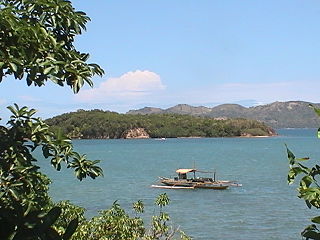
Guimaras[ɡimaˈɾas], officially the Province of Guimaras is an island province in the Philippines located in the Western Visayas region. Its capital is Jordan while its largest local government unit is the municipality of Buenavista. The province is situated in the Panay Gulf, between the islands of Panay and Negros. To the northwest is the province of Iloilo and to the southeast is Negros Occidental. The whole island is part of the Metro Iloilo–Guimaras, one of the twelve metropolitan areas of the Philippines.

Buenavista, officially the Municipality of Buenavista, is a 2nd class municipality and the largest settlement in the province of Guimaras, Philippines. According to the 2020 census, it has a population of 52,899 people.

Jordan, officially the Municipality of Jordan, is a 3rd class municipality and capital of the province of Guimaras, Philippines. According to the 2020 census, it has a population of 39,566 people, making it the third largest settlement in the province.

Nueva Valencia, officially the Municipality of Nueva Valencia, is a 3rd class municipality in the province of Guimaras, Philippines. According to the 2020 census, it has a population of 42,771 people.

On August 11, 2006, an oil spill occurred in the Panay Gulf when the oil tanker, MT Solar 1, sank off the coasts of Guimaras and Negros in the Philippines, causing what is considered to be the worst oil spill in the country's history.

The Iloilo Strait is a strait in the Philippines that separates the islands of Panay and Guimaras in the Visayas, and connects the Panay Gulf with the Guimaras Strait. It is the location of the Port of Iloilo, the third-busiest of the ports in the Philippines in number of ships. Iloilo City on Panay is the major city located on the strait with Buenavista and Jordan, both on Guimaras, immediately across the strait from the city. The Iloilo River empties into the strait.

Guimaras Strait is a strait in the Western Visayas region of the Philippines, connecting the Visayan Sea with the Panay Gulf and Sulu Sea beyond. To the north and west are Panay and Guimaras Islands, while Negros Island is to the south and east. Bacolod City is a major seaport on the strait, which also provides access to the Port of Iloilo City via the Iloilo Strait.

Pan de Azucar, variously known as Tampisaw Island or Tambaliza, is a populated island in the Visayan Sea in the Philippines. The island is known for MountPan de Azucar a steep volcanic cone and a prominent landmark at the northern entrance of Guimaras Strait.
Bayas Island is a small island and barangay in northeastern Iloilo, Philippines. It is part of the municipality of Estancia. According to the 2010 census, it has a population of 2,316. The Island was titled to Filomena Reyes Aclaro and is now shared to the locals.
Loguingot is a small island-barangay in northeastern Iloilo, Philippines. It is part of the municipality of Estancia. According to the 2010 census, it has a population of 796. Fishing is the main source of income for the island's residents.
The Concepcion Islands are 17 variously inhabited and uninhabited islands in northeastern Iloilo, Philippines. The islands are politically subdivided into 11 island barangays and are part of the municipality of Concepcion. According to the 2010 census, the islands collectively have a population of 19,080, 48 percent the total population of Concepcion.
Botlog Island is an island and barangay in northeastern Iloilo, Philippines. It is part of the municipality of Concepcion. According to the 2010 census, it has a population of 441.
Malangabang is an island and barangay in northeastern Iloilo, Philippines. It is part of the municipality of Concepcion. According to the 2010 census, it has a population of 2,925. Fishing is the main source of income for the island's residents.The Owner is Honorato Ciriaco.
Bulubadiangan Island is a privately owned island in northeastern Iloilo, Philippines. It is part of barangay Polopińa, Concepcion. The Sandbar Island Beach Resort on Bulubadiangan is moderately known within the Philippines.
Danao-Danao Island is a small, low-lying island in northeastern Iloilo, Philippines. It is part of the municipality of Concepcion.
Baliguian Island is an inhabited island in northeastern Iloilo, Philippines. It is the westernmost of the Concepcion Islands and politically administered by the municipality of Concepcion. A virtually flat island, Baliguian features a lighthouse to aid in ship navigation.
Magalumbi is an island in northeastern Iloilo, Philippines. It is part of the municipality of Batad, although the official provincial government website lists it as an offshore island of Estancia. Magalumbi is part of barangay Tanao, which has a population of 1,903 according to the 2010 census.
Manlot is an island-barangay in northeastern Iloilo, Philippines. It is one of fourteen islands politically administered by the municipality of Carles.
Calagnaan is an island in northeastern Iloilo, Philippines. It is one of fourteen islands politically administered by the municipality of Carles. The population of the island is 5,017 as of 2020 census.
Binuluangan is an inhabited island-barangay in northeastern Iloilo, Philippines. It is one of fourteen islands politically administered by the municipality of Carles. In 2010 it had a population of 1,682. There is an elementary school on the island.

