Chitipa District is the northernmost district in the Northern Region of Malawi. The capital is Chitipa. The district covers an area of 4,288 km.², and has a population of 234,927. Chitipa borders fellow districts Karonga and Rumphi, as well as neighboring countries Tanzania and Zambia. The district is divided into five main areas known as Misuku to the east, Kameme to the north, Bulambia right at the centre while Wenya and Nthalire areas are situated to the south.

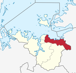
Tabora Region is one of Tanzania's 31 administrative regions. The regional capital is the municipality of Tabora. The region is located in mid-western part of Tanzania. Tabora is bordered by Shinyanga to the north, Singida to the east, Mbeya and Songwe to the south. lastly, Katavi, Kigoma and Geita, border Tabora to the west. Tabora is by far the largest region in Tanzania by area. Most of the population in the region is concentrated in the north in Nzega district. According to the 2022 national census, Tabora Region had a population of 3,391,679.

Maswa District is one of the five districts of the Simiyu Region of Tanzania Inhabited by Sukuma. It is bordered to the north by Magu District and Itilima District, to the east by the Meatu District, to the south by the Kishapu District, and to the west by the Kwimba District. Its administrative centre is the town of Maswa.
Magu District is one of the seven districts of the Mwanza Region of Tanzania, East Africa. Its administrative centre is the town of Magu on the Simiyu River. It is bordered to the north by Lake Victoria and Busega District, to the east by Bariadi District, to the south by Itilima District, Maswa District, Kwimba District and Misungwi District, and to the west by the city of Mwanza, which consists of Nyamagana District and Ilemela District.

Urambo is one of the seven districts of the Tabora Region of Tanzania. It is bordered to the north by the Kaliua District, to the east by the Uyui District, to the southeast by the Sikonge District, and to the southwest by the Katavi Region. Its administrative seat is the town of Urambo.
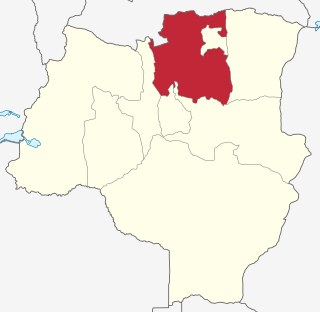
Nzega District is one of the seven districts of the Tabora Region of Tanzania. It is bordered to the north by Shinyanga Region, to the south and southwest by Uyui District and to the east by Igunga District. Its administrative seat is the town of Nzega.

Uyui District is one of the seven districts of the Tabora Region of Tanzania. It is bordered to the north by Nzega District and Igunga District as well as by the Shinyanga Region, to the south by Sikonge District, to the west by Urambo District and Kaliua District, and to the east by the Singida Region. Tabora Urban District is an enclave within the Uyui District. Its administrative seat is the city of Tabora.

Sikonge District is one of the seven districts of the Tabora Region of Tanzania. The town of Sikonge is the administrative seat. The district has an area of 27,873 square kilometres (10,762 sq mi), but 26,834 square kilometres (10,361 sq mi) of it is in forest and game reserves. It is bordered to the northwest by Urambo District, to the north by Uyui District, to the east by Manyoni District of Singida Region, to the south by Chunya District of Mbeya Region, and to the southwest by Mlele District of Katavi Region.

Tarime District is one of the seven districts of the Mara Region of Tanzania, East Africa. It was previously known as the "North Mara District". Its district capital is Tarime town. It is bordered from the north to east by the Kenyan districts of Migori, Trans Mara and Kuria East and West Districts, and to the east by the Maasai Mara game reserve. To the south it is bordered across the Mara River by the Serengeti and Butiama districts, and to the west by Rorya District.

Masasi is one of the six districts of the Mtwara Region of Tanzania. It is bordered to the north by the Lindi Region, to the east by the Newala District, to the south by the Ruvuma River and Mozambique and to the west by Nanyumbu District.

Kilosa District is one of the six districts of the Morogoro Region of Tanzania. Its administrative seat is the town of Kilosa. Kilosa District covers 14,918 square kilometres (5,760 sq mi). It is bordered to the north by the Manyara Region, to the northeast by the Tanga Region, to the east by Mvomero District, to the southeast by Morogoro Rural District, to the south by Kilombero District, to the southwest by the Iringa Region and to the west by the Dodoma Region. Kilosa District is home to Mikumi National Park.

Chunya District is one of the seven districts of Mbeya Region, Tanzania. It is bordered to the north by Tabora Region, to the northeast by Singida Region, to the east by Mbarali District, to the south by Mbeya Rural District, and to the west by Songwe District.

Mbozi District is a district in Songwe Region, Tanzania. It is bordered to the north by the Songwe District and Chunya District of the Mbeya Region, to the east by Mbeya Rural District of the Mbeya Region, to the south by the Ileje District and to the west by Momba District.

Hanang District is one of the six districts of the Manyara Region of Tanzania. It is bordered to the north by the Mbulu District and Babati Rural District, to the southeast by the Dodoma Region and to the southwest by the Singida Region. Mount Hanang is located within the boundaries of the district.

Ikungi District is one of the six districts of the Singida Region of Tanzania. It is one of the 20 new districts that were formed in Tanzania since 2010; it was split off from Singida Rural District. Ikungi District is bordered to the north by Iramba District, Singida Urban District and Singida Rural District, to the east by Manyara Region, to the south by Manyoni District and to the west by Tabora Region. Its administrative seat is the town of Ikungi.

Manyoni District is one of the six districts in the Singida Region of Tanzania. The district capital is the town of Manyoni. The district is bordered to the north by the Ikungi District, to the east by the Dodoma Region, to the south by the Iringa Region, to the southwest by the Mbeya Region and to the west by the Tabora Region. In 2015 the Itigi District was created from the Manyoni District, separating the Itigi Division that was the large portion of the south western of the district.

Micheweni District is one of two administrative districts of Pemba North Region in Tanzania. The district covers an area of 231.1 km2 (89.2 sq mi). The district is comparable in size to the land area of Cook Islands. The district has a water border to the east, north and west by the Indian Ocean. The district is bordered to the south by Wete District. The district seat (capital) is the town of Konde. According to the 2022 census, the district has a total population of 123,379.

Kalambo District is one of the four districts of the Rukwa Region of Tanzania, East Africa. The administrative seat is in Matai. The Kalambo River flows through the district and its mouth on Lake Tanganyika is about 15 km south of the town of Kasanga.

Kakonko District is one of the eight districts of the Kigoma Region of Tanzania. It is one of the 20 new districts that were formed in Tanzania since 2010; it was split off from Kibondo District. Kakonko District is bordered to the north by Kagera Region, to the east by Geita Region, to the south by Kibondo District, and to the west by Burundi. Its administrative seat is the town of Kakonko.

Chemba District is one of the seven districts of the Dodoma Region of Tanzania. It was formed after 2010, when it was split off from Kondoa District. Chemba District is bordered to the north by Kondoa District, to the east by Manyara Region, to the south by Chamwino District and Bahi District, and to the west by Singida Region. Its administrative seat is the town of Chemba.
