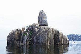
Mwanza City, also known as Rock City to the residents, is a port city and capital of Mwanza Region on the southern shore of Lake Victoria in north-western Tanzania. With an urban population of 1,182,000 in 2021, it is Tanzania's second largest city, after Dar es Salaam. It is also the second largest city in the Lake Victoria basin after Kampala, Uganda and ahead of Kisumu, Kenya at least in population size. Within the East African community, Mwanza city is the fifth largest city after Dar, Nairobi, Mombasa, and Kampala. It is slightly ahead of Kigali, Kisumu, and Bujumbura in the population of city proper limits. However, in terms of infrastructure, Kigali and Kisumu cities are way ahead of Mwanza. Mwanza city is also the capital city of Mwanza Region, and is administratively divided into two municipal districts within that Region - Ilemela and Nyamagana.

Kigoma is a city and lake port in Kigoma-Ujiji District in Tanzania, on the northeastern shores of Lake Tanganyika and close to the border with Burundi and The Democratic Republic of the Congo. It serves as the capital for the surrounding Kigoma Region and has a population of 232,388. The city is situated at an elevation of 775 metres (2,543 ft).

Tabora is the capital of Tanzania's Tabora Region and is classified as a municipality by the Tanzanian government. It is also the administrative seat of Tabora Urban District. According to the 2012 census, the district had a population of 226,999.

Dar es Salaam Region is one of Tanzania's 31 administrative regions and is located in the east coast of the country. The region covers an area of 1,393 km2 (538 sq mi). The region is comparable in size to the combined land and water areas of the nation state of Mauritius Dar es Salaam Region is bordered to the east by Indian Ocean and it is entirely surrounded by Pwani Region. The Pwani districts that border Dar es Salaam region are Bagamoyo District to the north, Kibaha Urban District to the west, Kisarawe District to the south west and Mkuranga District to the south of the region. The region's seat (capital) is located inside the ward of Ilala. The region is named after the city of Dar es Salaam itself. The region is home to Tanzania's major finance, administration and industries, thus the making it the country's richest region. According to the 2022 census, the region has a total population of 5,383,728 and national census of 2012 had 4,364,541. The region has the highest population in Tanzania followed by Mwanza Region.
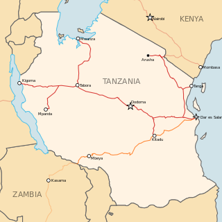
The Central Line, formerly known as the Tanganyika Railway is the most important railway line in Tanzania, apart from TAZARA. It runs west from Dar es Salaam to Kigoma on Lake Tanganyika via Dodoma. A branch leads to Mwanza on Lake Victoria.

Temeke District, offcially the Temeke Municipal Council is one of five districts of the Dar es Salaam Region of Tanzania. Temeke is bordered to the south by the Mkuranga District of the Pwani Region, to the north by the Indian Ocean, and to the northwest by the Ilala District. Temeke's eastern boundary is shared by Kigamboni District. The district covers an area of 240 km2 (93 sq mi). The district is comparable in size to the land area of Cook Islands. The administrative seat is Miburani. The district is home to the University of Dar es Salaam's School of Education, the National Stadium, the largest stadium in the country, and Port of Dar es Salaam the largest in the country. The 2012 National Tanzania Census states the population of the district as 1,205,949.

Ilala District, officially the Ilala Municipal Council is one of five districts of the Dar es Salaam Region of Tanzania. The district is bordered to the north and northeast by Kinondoni District and Ubungo District, to the east by the Zanzibar Channel, the west by Pwani Region, and to the south by the Temeke District. It covers an area of 365 km2 (141 sq mi). The district is comparable in size to the land area of U.S Virgin Islands. The administrative seat is Mchafukoge. The 2012 National Tanzania Census states the population for Ilala as 1,220,611.

Mwanza Region is one of Tanzania's 31 administrative regions The region covers a land area of 25,233 km2 (9,743 sq mi). The region is comparable in size to the combined land area of the nation state of North Macedonia. Mwanza Region is bordered to the north through Lake Victoria by the Kagera Region and Mara Region, to the east by Simiyu Region, to the south by the Shinyanga Region and to the west by Geita Region. The regional capital is the city of Mwanza. According to the 2022 national census, the region had a population of 3,699,872 and national census of 2012 had 2,772,509. Mwanza Region is the second region with high population in Tanzania after Dar es Salaam Region

Shinyanga Region is one of Tanzania's 31 administrative regions. The region covers a land area of 18,555 km2 (7,164 sq mi). The region is comparable in size to the combined land area of the nation state of Fiji. The region is bordered to the north by the Mwanza, Mara, and Kagera Regions and to the south by the Tabora Region. In addition, the Kigoma Region borders the region to the west, and the Simiyu Region and a sliver of Singida Region to the east. The regional capital is the municipality of Shinyanga. According to the 2012 national census, the region had a population of 1,534,808.

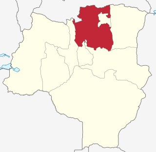
Tabora Region is one of Tanzania's 31 administrative regions. The regional capital is the municipality of Tabora. The region is located in mid-western part of Tanzania. Tabora is bordered by Shinyanga to the north, Singida to the east, Mbeya and Songwe to the south. lastly, Katavi, Kigoma and Geita, border Tabora to the west. Tabora is by far the largest region in Tanzania by area. Most of the population in the region is concentrated in the north in Nzega district. According to the 2012 national census, Tabora Region had a population of 2,291,623.

Urambo is one of the seven districts of the Tabora Region of Tanzania. It is bordered to the north by the Kaliua District, to the east by the Uyui District, to the southeast by the Sikonge District, and to the southwest by the Katavi Region. Its administrative seat is the town of Urambo.
Nzega District is one of the seven districts of the Tabora Region of Tanzania. It is bordered to the north by Shinyanga Region, to the south and southwest by Uyui District and to the east by Igunga District. Its administrative seat is the town of Nzega.

Uyui District is one of the seven districts of the Tabora Region of Tanzania. It is bordered to the north by Nzega District and Igunga District as well as by the Shinyanga Region, to the south by Sikonge District, to the west by Urambo District and Kaliua District, and to the east by the Singida Region. Tabora Urban District is an enclave within the Uyui District. Its administrative seat is the city of Tabora.

Sikonge District is one of the seven districts of the Tabora Region of Tanzania. The town of Sikonge is the administrative seat. The district has an area of 27,873 square kilometres (10,762 sq mi), but 26,834 square kilometres (10,361 sq mi) of it is in forest and game reserves. It is bordered to the northwest by Urambo District, to the north by Uyui District, to the east by Manyoni District of Singida Region, to the south by Chunya District of Mbeya Region, and to the southwest by Mlele District of Katavi Region.

Rorya District is a district in Mara Region, United Republic of Tanzania. The district capital is the small town of Ingri Juu, while the largest town is Shirati. The district was created in 2007 from a part of Tarime District. It is bordered by Tarime District to the east, Butiama District to the south, Lake Victoria to the west, and the Republic of Kenya to the north. The majority of inhabitants are from the Luo tribe. Other ethnic group is Kurya. Kine, Simbiti,Sweta and Hacha are sub-groups within Kurya ethnic group.

Uvinza is one of the eight administrative districts of Kigoma Region in Tanzania. Uvinza is bordered to the northwest by Kigoma District and Kigoma-Ujiji District. North of the district is bordered by Kasulu District. Lake Tanganyika borders the district on the west. Mpanda District in Katavi Region boders the district to the south and Kaliua District in Tabora Region borders the district to the east. The district is named in honor of the Vinza people whom the western part of district was their historic kingdom. Southern Uvinza District is home to the Mahale Mountains National Park. A unique park that is home to both Chimpanzees and lions in the same habitat.
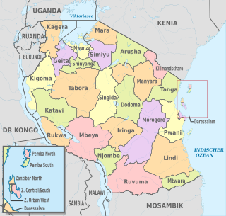
The administrative divisions of Tanzania are controlled by Part I, Article 2.2 of the Constitution of Tanzania. Tanzania is divided into thirty-one regions. Each region is subdivided into districts. The districts are sub-divided into divisions and further into local wards. Wards are further subdivided for management purposes: for urban wards into streets and for rural wards into villages. The villages may be further subdivided into hamlets.

Geita Region is one of Tanzania's 31 administrative regions. The region covers an area of 20,054 km2 (7,743 sq mi)."Geita Region Size". The region is comparable in size to the combined land area of the nation state of Slovenia. Geita Region is bordered to the east by Lake Victoria, Mwanza Region and Shinyanga Region. The region is bordered by Tabora Region and Kigoma Region to the south and south west respectively. Lastly, Gieta is borders Kagera Region to the west.

Katavi Region is one of Tanzania's 31 administrative regions. The region covers an area of 45,843 km2 (17,700 sq mi). The region is comparable in size to the combined land area of the nation state of Estonia. Kagera Region is bordered to the east by Tabora Region. The region is bordered to the south by Rukwa Region and Songwe Region. Lastly, Katavi borders DRC on Lake Tanganyika to the west. The region derives its name from Katavi, the spirit of lake Tanganyika. The regional capital city is Mpanda. According to the 2012 national census, the region had a population of 564,604.

Kaliua District is one of the seven districts of the Tabora Region of Tanzania. It is bordered to the north by Kahama and Ushetu Districts, to the east by Uyui District and Urambo District, to the south by Katavi Region and to the west by Uvinza District and Geita Region. Its administrative seat is the town of Kaliua.
