Tabora is the capital of Tanzania's Tabora Region and is classified as a municipality by the Tanzanian government. It is also the administrative seat of Tabora Urban District. According to the 2012 census, the district had a population of 226,999.

Unyanyembe is a town in Tanzania near Mwadui Airport in Shinyanga Region. It was one of the locations visited by Henry Morton Stanley during his search for Dr Livingstone. In the 19th-century it was the headquarters of a kingdom that controlled Tabora as well as other areas.

Kigoma Region is one of Tanzania's 31 administrative regions. The regional capital is the city of Kigoma. Kigoma Region borders Kagera Region, Geita Region, Katavi Region, Tabora Region, DRC and Burundi According to the 2012 national census, the region had a population of 2,127,930, which was higher than the pre-census projection of 1,971,332. For 2002-2012, the region's 2.4 percent average annual population growth rate was tied for the fourteenth highest in the country. It was also the sixteenth most densely populated region with 57 people per square kilometer. With a size of 45,066 square kilometres (17,400 sq mi), the region is slightly smaller than Estonia.

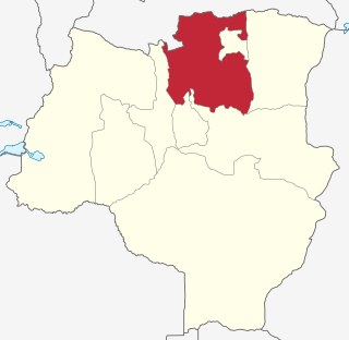
Tabora Region is one of Tanzania's 31 administrative regions. The regional capital is the municipality of Tabora. The region is located in mid-western part of Tanzania. Tabora is bordered by Shinyanga to the north, Singida to the east, Mbeya and Songwe to the south. lastly, Katavi, Kigoma and Geita, border Tabora to the west. Tabora is by far the largest region in Tanzania by area. Most of the population in the region is concentrated in the north in Nzega district. According to the 2022 national census, Tabora Region had a population of 3,391,679.
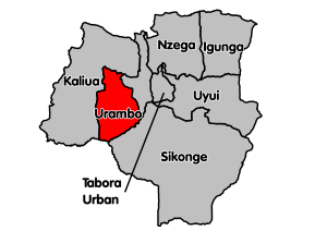
Mtyela Kasanda, better known as King Mirambo, was a Nyamwezi king, from 1860 to 1884. He created the largest state by area in 19th-century East Africa in present-day Urambo district in Tabora Region of Tanzania. Urambo district is named after him. He also built a capital for his territory at Iselemagazi.
Nzega District is one of the seven districts of the Tabora Region of Tanzania. It is bordered to the north by Shinyanga Region, to the south and southwest by Uyui District and to the east by Igunga District. Its administrative seat is the town of Nzega.

Uyui District is one of the seven districts of the Tabora Region of Tanzania. It is bordered to the north by Nzega District and Igunga District as well as by the Shinyanga Region, to the south by Sikonge District, to the west by Urambo District and Kaliua District, and to the east by the Singida Region. Tabora Urban District is an enclave within the Uyui District. Its administrative seat is the city of Tabora.

Sikonge District is one of the seven districts of the Tabora Region of Tanzania. The town of Sikonge is the administrative seat. The district has an area of 27,873 square kilometres (10,762 sq mi), but 26,834 square kilometres (10,361 sq mi) of it is in forest and game reserves. It is bordered to the northwest by Urambo District, to the north by Uyui District, to the east by Manyoni District of Singida Region, to the south by Chunya District of Mbeya Region, and to the southwest by Mlele District of Katavi Region.

Tabora Urban is one of the seven districts in the Tabora Region of Tanzania. This district is mostly the city of Tabora and its suburbs. It is bordered almost completely by the Uyui District. It has a small border with Nzega District to the north. Its administrative seat is the city of Tabora.

Biharamulo District is one of the eight districts of the Kagera Region of Tanzania. It is bordered to the north by Karagwe District and Muleba District, to the east and south by Geita Region, to the west by Ngara District, and to the southwest by the Kigoma Region. Its administrative seat is Biharamulo town. Biharamulo Game Reserve is located within the borders of the district.
Mpanda District is one of the five districts of the Katavi Region of Tanzania. Its administrative seat is the city of Mpanda. The district is bordered to the northwest by the Kigoma Region, to the northeast by the Tabora Region, to the east by the Mbeya Region, to the southeast by the Sumbawanga Urban District, to the southwest by the Nkasi District and to the west by Lake Tanganyika.

Kibondo District is one of the six districts of Kigoma Region, Tanzania. It is bordered to the north by the Kakonko District, to the east by the Tabora Region, to the south by the Uvinza District, to the west by the Kasulu District and to the northwest by Burundi.

Iramba is one of the six districts of the Singida Region of central Tanzania. It is bordered to the Northwest by the Shinyanga Region, to the North by Simiyu Region, to the east by the Mkalama District, to the South by Ikungi District and to the West by the Tabora Region. Its administrative seat is the town of Kiomboi.

Uvinza is one of the eight administrative districts of Kigoma Region in Tanzania. Uvinza is bordered to the northwest by Kigoma District and Kigoma-Ujiji District. North of the district is bordered by Kasulu District. Lake Tanganyika borders the district on the west. Mpanda District in Katavi Region boders the district to the south and Kaliua District in Tabora Region borders the district to the east. The district is named in honor of the Vinza people whom the western part of district was their historic kingdom. Southern Uvinza District is home to the Mahale Mountains National Park. A unique park that is home to both Chimpanzees and lions in the same habitat.

Geita Region is one of Tanzania's 31 administrative regions. The region covers an area of 20,054 km2 (7,743 sq mi)."Geita Region Size". The region is comparable in size to the combined land area of the nation state of Slovenia. Geita Region is bordered to the east by Lake Victoria, Mwanza Region and Shinyanga Region. The region is bordered by Tabora Region and Kigoma Region to the south and south west respectively. Lastly, Gieta is borders Kagera Region to the west.

Kaliua District is one of the seven districts of the Tabora Region of Tanzania. It is bordered to the north by Kahama and Ushetu Districts, to the east by Uyui District and Urambo District, to the south by Katavi Region and to the west by Uvinza District and Geita Region. Its administrative seat is the town of Kaliua.

Kakonko District is one of the eight districts of the Kigoma Region of Tanzania. It is one of the 20 new districts that were formed in Tanzania since 2010; it was split off from Kibondo District. Kakonko District is bordered to the north by Kagera Region, to the east by Geita Region, to the south by Kibondo District, and to the west by Burundi. Its administrative seat is the town of Kakonko.
Kigoma District is one of the eight administrative districts of Kigoma Region in Tanzania. The district lies north of the city of Kigoma-Ujiji. Uvinza District, to the west and south of Ujiji, was split off from the Kigoma District in 1 July, 2013.
Mkigo is an administrative ward in Kigoma District of Kigoma Region in Tanzania. The ward covers an area of 80 km2 (31 sq mi), and has an average elevation of 1,594 m (5,230 ft). In 2016 the Tanzania National Bureau of Statistics report there were 7,478 people in the ward, from 16,252 in 2012. Prior to 2014 Nyarubanda village and its hamlets were are part of the Mikigo Ward until they split off to for their own new ward.

Nsimbo District is a district council in the Katavi Region of Tanzania's Southern Highlands established in 2012. The district lies in the middle of the region east of the city of Mpanda. It is a tropical environment of mostly forest reserves and agricultural economy.