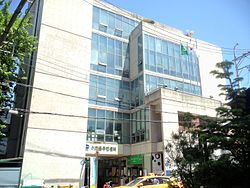
Ihwa-dong, Seoul

Last updated
Ihwa-dong
Korean transcription(s)
   Hangul 이화동
   Hanja 梨花洞
   Revised Romanization Ihwa dong
   McCune–Reischauer Ihwa tong
P00250516 114459479 ihwadongjuminsenteo.JPG
Ihwa-dong Community Service Center (Jongno District)
CountrySouth Korea
Area
  Total0.78 km2 (0.30 sq mi)
Population
 (2001) [1]
  Total11,722
  Density15,000/km2 (39,000/sq mi)

Ihwa-dong is a dong (neighborhood) of Jongno District, Seoul, South Korea. [1] [2]

Contents

ihwadong byeoghwamaeul ihwadong byeoghwamaeul Mural villiage in Ihwa-dong.jpg
이화동 벽화마을

See also

Related Research Articles

Cheongun-dong is a dong (neighborhood) of Jongno District, Seoul, South Korea.

Hyoja-dong is a dong (neighborhood) of Jongno District, Seoul, South Korea.

Changseong-dong is a dong (neighborhood) of Jongno District, Seoul, South Korea. It is a legal dong administered under its administrative dong, Hyoja-dong.

<span class="mw-page-title-main">Buam-dong, Seoul</span> Place in South Korea

Buam-dong is a dong (neighborhood) of Jongno District, Seoul, South Korea.

<span class="mw-page-title-main">Gyonam-dong</span> Place in South Korea

Gyonam-dong is a dong (neighborhood) of Jongno District, Seoul, South Korea.

<span class="mw-page-title-main">Hyehwa-dong</span> Place in South Korea

Hyehwa-dong is a dong (neighborhood) of Jongno District, Seoul, South Korea. It is adjacent to the Seoul National University Hospital.

<span class="mw-page-title-main">Sungin-dong</span> Place in South Korea

Sungin-dong is a dong, neighbourhood of Jongno-gu in Seoul, South Korea.

Dangju-dong is a dong (neighborhood) of Jongno District, Seoul, South Korea. It is a legal dong administered under its administrative dong, Sajik-dong.

Doryeom-dong is a dong (neighborhood) of Jongno District, Seoul, South Korea. It is a legal dong administered under its administrative dong, Sajik-dong. The name is originated from a governmental office named Doryeomseo in the region during the early period of Joseon dynasty.

Chebu-dong is a dong (neighborhood) of Jongno District, Seoul, South Korea. It is a legal dong administered under its administrative dong, Sajik-dong.

Pirun-dong is a dong, neighbourhood of Jongno-gu in Seoul, South Korea. It is a legal dong administered under its administrative dong, Sajik-dong.

<span class="mw-page-title-main">Hongji-dong</span> Place in South Korea

Hongji-dong is a dong (neighborhood) of Jongno District, Seoul, South Korea. It is a legal dong administered under its administrative dong, Buam-dong.

<span class="mw-page-title-main">Anguk-dong</span> Place in South Korea

Anguk-dong is a dong, neighbourhood of Jongno District in Seoul, South Korea. It is a legal dong administered under its administrative dong, Samcheong-dong.

<span class="mw-page-title-main">Hwa-dong</span> Place in South Korea

Hwa-dong is a dong (neighborhood) of Jongno District, Seoul, South Korea. It is a legal dong administered under its administrative dong, Samcheong-dong.

Gyobuk-dong is a dong (neighborhood) of Jongno District, Seoul, South Korea. It is a legal dong administered under its administrative dong, Gyonam-dong.

Pyeong-dong is a dong, neighbourhood of Jongno-gu in Seoul, South Korea. It is a legal dong administered under its administrative dong, Gyonam-dong.

Hongpa-dong is a dong (neighborhood) of Jongno District, Seoul, South Korea. It is a legal dong administered under its administrative dong, Gyonam-dong.

Dongsung-dong is a dong (neighborhood) of Jongno District, Seoul, South Korea. It is a legal dong administered under its administrative dong, Ihwa-dong.

Yeongeon-dong is a dong, neighbourhood of Jongno-gu in Seoul, South Korea. It is a legal dong administered under its administrative dong, Ihwa-dong.

Cheongjin-dong is a dong (neighborhood) of Jongno District, Seoul, South Korea. It is a legal dong administered under its administrative dong, Jongno.

References

  1. 1 2 이화동 (Ihwa-dong 梨花洞) (in Korean). Doosan Encyclopedia . Retrieved 2008-04-23.[ permanent dead link ]
  2. "Origin of Ihwa-dong's name" (in Korean). Jongno District official site. Archived from the original on 2004-08-20. Retrieved 2008-04-23.

37°35′N127°00′E / 37.583°N 127.000°E / 37.583; 127.000