
Whitefish Bay is a large bay on the eastern end of Lake Superior between Michigan, United States, and Ontario, Canada. It is located between Whitefish Point in Michigan and Whiskey Point along the more rugged, largely wilderness Canadian Shield of Ontario. The international border runs through the bay, which is heavily used by shipping traffic northbound from and southbound to the Soo Locks.
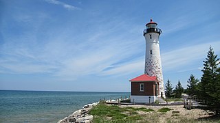
Crisp Point was one of five U.S. Life-Saving Service Stations along the coast of Lake Superior between Munising and Whitefish Point in the Upper Peninsula of Michigan. The lighthouse is within McMillan Township in Luce County.

The Michigan Island Lighthouse is a lighthouse operated by the National Park Service and located on Michigan Island on western Lake Superior in the Apostle Islands National Lakeshore.

The La Pointe Light is a lighthouse located on Long Island, one of the Apostle Islands, in Lake Superior in Ashland County, Wisconsin, near the city of Bayfield.
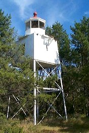
The Chequamegon Point Lighthouse is a lighthouse located on Long Island, one of the Apostle Islands, in Lake Superior in Ashland County, Wisconsin, near the city of Bayfield.

The Devils Island Lighthouse is a lighthouse located on Devils Island, one of the Apostle Islands, in Lake Superior in Ashland County, Wisconsin, near the city of Bayfield. Among the Apostle Islands lighthouses—a testament to its remoteness—it was the last built, and the last automated and unmanned.

There are several historic lighthouses on Lake Superior on or near the Apostle Islands in Wisconsin. Six of these lighthouses, all in the Apostle Islands National Lakeshore, were listed as a group on the National Register of Historic Places in 1977 under the name Apostle Islands Lighthouses.

The Raspberry Island Lighthouse is a lighthouse located on the southern part of Raspberry Island, marking the west channel of the Apostle Islands in Lake Superior in Bayfield County, Wisconsin, near the city of Bayfield. It was erected in 1862, marking the western channel.
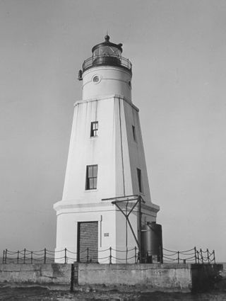
The Ashland Harbor Breakwater lighthouse, also known as Ashland Breakwater Lighthouse, is an operational lighthouse located near Ashland in Ashland County, Wisconsin, USA. Located in Chequamegon Bay of Lake Superior, it is owned and managed by the National Park Service, and is a part of the Apostle Islands National Lakeshore. It sits at the end of a long and detached breakwater, which creates an artificial harbor.

The Chambers Island lighthouse is a lighthouse located on Chambers Island in Door County, Wisconsin. It was replaced in 1961 by a skeletal tower, visible for 12 nautical miles. The new light is identified by the USCG as 7-21895.

The Whitefish Point Light is a lighthouse located in Chippewa County in the U.S. state of Michigan. Located on the southeastern shores of Lake Superior, it sits at the edge of Whitefish Point leading to Whitefish Bay. Constructed in 1849, it is the oldest operating lighthouse in the Upper Peninsula. All vessels entering or exiting Lake Superior pass near Whitefish Point. The area is infamously known as the "Graveyard of the Great Lakes" due to the high number of shipwrecks in the area, most famously the SS Edmund Fitzgerald.
Manitou Island is a small island in Lake Superior, off the northeastern tip of the Keweenaw Peninsula in the U.S. state of Michigan. It is part of Grant Township, in Keweenaw County. Located approximately three miles from the mainland, it encompasses around 1,000 acres (4.0 km2). Manitou has seen limited impact from human activity because of its remote location and the often-treacherous waters caused by a strong current at the peninsula's tip. It is mostly forested, with scattered bogs and an inland lake known as "Perch Lake". Dense underbrush can make travel around the island rather difficult, though a few unimproved trails do exist. The Keweenaw Land Trust protects 93 acres (0.38 km2) of the island as the Manitou Island Light Station Preserve.

The Neenah Light is located in Kimberly Point Park in Neenah, Wisconsin. The lighthouse marks the entrance of Lake Winnebago into the Lower Fox River.
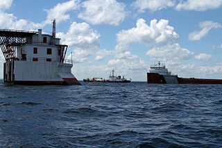
The Gros Cap Reefs Light is a lighthouse located at the entrance to St. Mary's River from Whitefish Bay of Lake Superior. The light was completed in 1953 and replaced a lightship stationed there since 1923. The lighthouse, owned by the Canadian Coast Guard, is located on the southwest edge of the Gros Cap Reef.
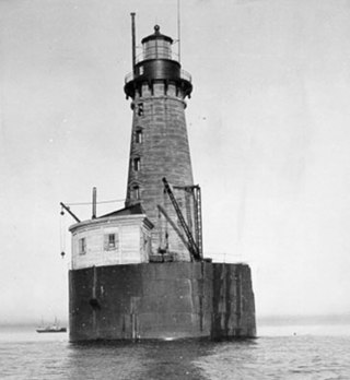
The Stannard Rock Light is a lighthouse located on a reef that was the most serious hazard to navigation on Lake Superior. The exposed crib of the Stannard Rock Light is rated as one of the top ten engineering feats in the United States. It is 24 miles (39 km) from the nearest land, making it the most distant lighthouse in the United States. It was one of the "stag stations", manned only by men, and had the nickname "The Loneliest Place in the World".

SS Myron was a wooden steamship built in 1888. She spent her 31-year career as lumber hooker, towing schooner barges on the Great Lakes. She sank in 1919, in a Lake Superior November gale. All of her 17 crew members were killed but her captain survived. He was found drifting on wreckage near Ile Parisienne. Her tow, the Miztec, survived. Myron defied the adage that Lake Superior "seldom gives up her dead" when all 17 crewmembers were found frozen to death wearing their life jackets. Local residents chopped eight of Myron's sailors from the ice on the shore of Whitefish Bay and buried them at the Mission Hill Cemetery in Bay Mills Township, Michigan.
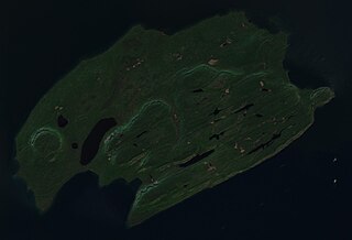
Pie Island is an island in Lake Superior, Ontario, Canada, located about 10 kilometres (6.2 mi) south of Thunder Bay and 25 kilometres (16 mi) north of Isle Royale, Michigan. It is about 12 kilometres (7.5 mi) long with an area of 46 square kilometres (18 sq mi). Pie Island is readily visible from the shoreline and high parts of the city of Thunder Bay.

The Ile Parisienne Light was built in 1911 on the southern tip of remote Ile Parisienne in the middle of Whitefish Bay on Lake Superior on a major shipping lane for ingress/egress to the Soo Locks. It is now a well-known landmark to shipping traffic and pleasure craft. The light is automated and remains seasonally active.
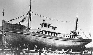
CGS Lambton was a lighthouse tender that operated for the Canadian government on the Great Lakes in the early 20th century.


