
In geography, latitude is a coordinate that specifies the north–south position of a point on the surface of the Earth or another celestial body. Latitude is given as an angle that ranges from −90° at the south pole to 90° at the north pole, with 0° at the Equator. Lines of constant latitude, or parallels, run east–west as circles parallel to the equator. Latitude and longitude are used together as a coordinate pair to specify a location on the surface of the Earth.
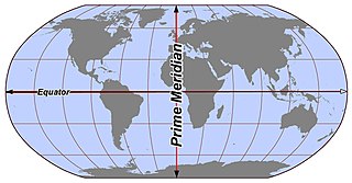
Longitude is a geographic coordinate that specifies the east–west position of a point on the surface of the Earth, or another celestial body. It is an angular measurement, usually expressed in degrees and denoted by the Greek letter lambda (λ). Meridians are imaginary semicircular lines running from pole to pole that connect points with the same longitude. The prime meridian defines 0° longitude; by convention the International Reference Meridian for the Earth passes near the Royal Observatory in Greenwich, south-east London on the island of Great Britain. Positive longitudes are east of the prime meridian, and negative ones are west.

The Mercator projection is a conformal cylindrical map projection first presented by Flemish geographer and mapmaker Gerardus Mercator in 1569. In the 18th century, it became the standard map projection for navigation due to its property of representing rhumb lines as straight lines. When applied to world maps, the Mercator projection inflates the size of lands the further they are from the equator. Therefore, landmasses such as Greenland and Antarctica appear far larger than they actually are relative to landmasses near the equator. Nowadays the Mercator projection is widely used because, aside from marine navigation, it is well suited for internet web maps.

A geographic coordinate system (GCS) is a spherical or geodetic coordinate system for measuring and communicating positions directly on Earth as latitude and longitude. It is the simplest, oldest and most widely used of the various spatial reference systems that are in use, and forms the basis for most others. Although latitude and longitude form a coordinate tuple like a cartesian coordinate system, the geographic coordinate system is not cartesian because the measurements are angles and are not on a planar surface.

In cartography, a map projection is any of a broad set of transformations employed to represent the curved two-dimensional surface of a globe on a plane. In a map projection, coordinates, often expressed as latitude and longitude, of locations from the surface of the globe are transformed to coordinates on a plane. Projection is a necessary step in creating a two-dimensional map and is one of the essential elements of cartography.

The Tropic of Cancer, also known as the Northern Tropic, is the Earth's northernmost circle of latitude where the Sun can be seen directly overhead. This occurs on the June solstice, when the Northern Hemisphere is tilted toward the Sun to its maximum extent. It also reaches 90 degrees below the horizon at solar midnight on the December Solstice. Using a continuously updated formula, the circle is currently 23°26′09.9″ (or 23.43607°) north of the Equator.

The Tropic of Capricorn is the circle of latitude that contains the subsolar point at the December solstice. It is thus the southernmost latitude where the Sun can be seen directly overhead. It also reaches 90 degrees below the horizon at solar midnight on the June Solstice. Its northern equivalent is the Tropic of Cancer.

A circle of latitude or line of latitude on Earth is an abstract east–west small circle connecting all locations around Earth at a given latitude coordinate line.
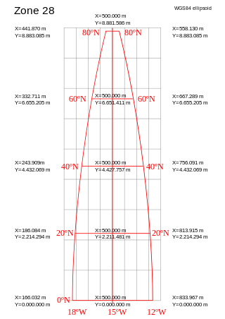
A projected coordinate system – also called a projected coordinate reference system, planar coordinate system, or grid reference system – is a type of spatial reference system that represents locations on Earth using Cartesian coordinates (x, y) on a planar surface created by a particular map projection. Each projected coordinate system, such as "Universal Transverse Mercator WGS 84 Zone 26N," is defined by a choice of map projection (with specific parameters), a choice of geodetic datum to bind the coordinate system to real locations on the earth, an origin point, and a choice of unit of measure. Hundreds of projected coordinate systems have been specified for various purposes in various regions.

In navigation, a rhumb line, rhumb, or loxodrome is an arc crossing all meridians of longitude at the same angle, that is, a path with constant bearing as measured relative to true north.

The qibla is the direction towards the Kaaba in the Sacred Mosque in Mecca, which is used by Muslims in various religious contexts, particularly the direction of prayer for the salah. In Islam, the Kaaba is believed to be a sacred site built by prophets Abraham and Ishmael, and that its use as the qibla was ordained by God in several verses of the Quran revealed to Muhammad in the second Hijri year. Prior to this revelation, Muhammad and his followers in Medina faced Jerusalem for prayers. Most mosques contain a mihrab that indicates the direction of the qibla.
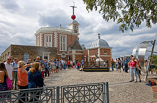
The Greenwich meridian is a prime meridian, a geographical reference line that passes through the Royal Observatory, Greenwich, in London, England. From 1884 to 1974, the Greenwich meridian was the international standard prime meridian, used worldwide for timekeeping and navigation. The modern standard, the IERS Reference Meridian, is based on the Greenwich meridian, but differs slightly from it. This prime meridian was first established by Sir George Airy in 1851, and by 1884, over two-thirds of all ships and tonnage used it as the reference meridian on their charts and maps. In October of that year, at the invitation of the President of the United States, 41 delegates from 25 nations met in Washington, D.C., United States, for the International Meridian Conference. This conference selected the meridian passing through Greenwich as the world standard prime meridian due to its popularity. However, France abstained from the vote, and French maps continued to use the Paris meridian for several decades. In the 18th century, London lexicographer Malachy Postlethwayt published his African maps showing the "Meridian of London" intersecting the Equator a few degrees west of the later meridian and Accra, Ghana.
In geography and geodesy, a meridian is the locus connecting points of equal longitude, which is the angle east or west of a given prime meridian. In other words, it is a line of longitude. The position of a point along the meridian is given by that longitude and its latitude, measured in angular degrees north or south of the Equator. On a Mercator projection or on a Gall-Peters projection, each meridian is perpendicular to all circles of latitude. A meridian is half of a great circle on Earth's surface. The length of a meridian on a modern ellipsoid model of Earth has been estimated as 20,003.93 km (12,429.87 mi).
In geography, location or place are used to denote a region on Earth's surface. The term location generally implies a higher degree of certainty than place, the latter often indicating an entity with an ambiguous boundary, relying more on human or social attributes of place identity and sense of place than on geometry. A populated place is called a settlement.
True north is the direction along Earth's surface towards the place where the imaginary rotational axis of the Earth intersects the surface of the Earth. That place is called the True North Pole. True south is the direction opposite to the true north. North per se is one of the cardinal directions, a system of naming orientations on the Earth. There are multiple ways of determining the North in different contexts.

The 180th meridian or antimeridian is the meridian 180° both east and west of the prime meridian in a geographical coordinate system. The longitude at this line can be given as either east or west.
The equator is a circle of latitude that divides a spheroid, such as Earth, into the Northern and Southern hemispheres. On Earth, the Equator is an imaginary line located at 0 degrees latitude, about 40,075 km (24,901 mi) in circumference, halfway between the North and South poles. The term can also be used for any other celestial body that is roughly spherical.
This glossary of geography terms is a list of definitions of terms and concepts used in geography and related fields, including Earth science, oceanography, cartography, and human geography, as well as those describing spatial dimension, topographical features, natural resources, and the collection, analysis, and visualization of geographic data. It is split across two articles:

The Arctic Circle is one of the two polar circles, and the most northerly of the five major circles of latitude as shown on maps of Earth at about 66° 34' N. Its southern equivalent is the Antarctic Circle.
