Imperial Palace, Gelnhausen

Last updated
Imperial Palace Gelnhausen
Kaiserpfalz Gelnhausen
Pfalz Gelnhausen - panoramio.jpg
From left to right: Rectangle keep, gate house, palas facade
Hesse location map.svg
Red pog.svg
Germany adm location map.svg
Red pog.svg
Alternative namesPfalz Gelnhausen
General information
Statusin ruins
Typepalace
Architectural styleRomanesque
Town or cityGelnhausen
CountryGermany
OwnerState of Hesse

The Imperial Palace at Gelnhausen (called in German Kaiserpfalz Gelnhausen, Pfalz Gelnhausen or Barbarossaburg) is located on a former island in the Kinzig river in Gelnhausen, Hesse, Germany.

Contents

Site

Position of Kaiserpfalz and outer bailey on the Kinzig island:
1 Palace area, 2 Outer bailey, 3 Street to Gelnhausen, 4 Street to the upper Kinzig valley, 5 Street to Altenhasslau (nowadays: Linsengericht, 6 Mill, 7 Mullerwiese GN Inselkarte final.tif
Position of Kaiserpfalz and outer bailey on the Kinzig island:
1 Palace area, 2 Outer bailey, 3 Street to Gelnhausen, 4 Street to the upper Kinzig valley, 5 Street to Altenhaßlau (nowadays: Linsengericht, 6 Mill, 7Müllerwiese

The Palace was built during the decades of 1160–1180. The town in its neighbourhood (officially founded in 1170) was closely linked to the palace. The site of the palace was an island in the Kinzig river. The foundation of the walls and buildings was very difficult in such a soft underground and structural stability of the buildings proved a problem until today. The underground was stabilised by about 12,000 wooden poles on which the buildings stand.

Together with the palace an outer bailey was placed on the island containing the houses of the Burgmannen, a settlement in its own right independent from the town of Gelnhausen until the beginning of the 19th century.

The palace lay at the eastern rim of Wetterau, an imperial territory, and enabled its administration together with other imperial castles such as Frankfurt, Friedberg, Wetzlar, Trebur and Seligenstadt. The Gelnhausen palace also controlled the important long-distance highway Via Regia between Frankfurt and Leipzig as it passes through the valley of the Kinzig river.

History

Both, palace and town, go back to Emperor Frederick I (Barbarossa). The exact date when construction of the palace began was much disputed by historians. Debate revolved around the question of whether the building of the palace took place a few years before the official founding of the royal town in 1170. The relative chronology of the erection of its buildings is known since several decades due to a large amount of Mason's marks on the building site. [1] About 60 different masons have worked on the site but never more than 10 to 20 at the same time. [2] In 1992 it was possible to extract several poles of the wooden sub construction from under the gate building during restoration works. Three of them could be analyzed by Dendrochronology, all three dating into the winter 1169/70 or the summer of 1170. So, knowing by the Mason's marks that the gate building was erected well into the second half of the building activities it gives the two decades between 1160 and 1180 as the time of construction.

In 1180, the imperial palace at Gelnhausen was the venue for the great imperial court or Hoftag of Gelnhausen, at which Henry the Lion was put on trial in his absence and his imperial fiefs redistributed. [3] The now ruined palas was probably used as an assembly hall for this event. [4] In the years that followed, further imperial courts were convened at Gelnhausen.

During the Hohenstaufen era, the palace was an Imperial Castle (Reichsburg), had a burgrave and Burgmannen. Its estate included Büdingen Forest  [ de ], in which the occupants of the outer bailey still retained timber rights (for construction and firewood) until the 19th century. The decline of the palace began as early as the 14th century when, in 1349, Emperor Charles IV (HRR) enfeoffed it, together with the town, to the Counts of Schwarzburg and never reclaimed it. In 1431, the Count of Hanau and Count Palatine Louis III procured the palace and town from Count Henry of Schwarzburg. During the Thirty Years' War (1618–1648), the town and palace were severely damaged.

After the death of Johann Reinhard III, Count of Hanau-Lichtenberg, the last male member of the House of Hanau, in 1736, the Landgraves of Hesse-Kassel inherited the Hanau half of Gelnhausen and later bought the other half owned by the Electors of Palatinate. The palace was then used as a quarry until 1811. Around 1810, the palace became one of the first buildings from the epoch of Romanesque architecture in Germany that attracted the interest of art-loving scholars. [5] So it was forbidden to use the buildings as a quarry further on and first attempts to secure them started. Not withstanding this the castle chapel, used for Protestant services between 1764 and 1811 was demolished in 1856 due to the expected costs of an otherwise necessary restoration.

Current Use

Today, the palace belongs to the state of Hesse and is managed by the State Castles and Gardens of Hesse (Staatliche Schlösser und Gärten Hessen). Along with an attached castle museum, it is open to the public.

Buildings

Floor plan: 1 Palas, 2 Gate hall (ground level), chapel (1st floor), 3 Entrance, 4 Rectangle keep, 5 Round keep, 6 Living quarters (vanished), 7 Service and living quarters (vanished), 8 Latrines Grundriss Kaiserpfalz Gelnhausen.tif
Floor plan: 1 Palas, 2 Gate hall (ground level), chapel (1st floor), 3 Entrance, 4 Rectangle keep, 5 Round keep, 6 Living quarters (vanished), 7 Service and living quarters (vanished), 8 Latrines
Palas facade - in the background: Marienkirche, Gelnhausen Gelnhausen Kaiserpfalz.jpg
Palas facade – in the background: Marienkirche, Gelnhausen
Detail of the palas Gelnhausen Kaiserpfalz 46.JPG
Detail of the palas

Ring wall

The ring wall is 2.10 m thick and encloses the complex with eight bends, most of whose buildings used it as a rear wall. Therefore, it is smoothly designed inwardly in the places where buildings adjoined, while on the rest and outwardly humped ashlars were used. [6] The wall preserved in some sections up to a height of 5.50 m, but in no place up to the original height of the battlement at about 5.80 m above the ground level, which can be concluded from the connection points at the square keep. [7]

Gate, chapel and rectangle keep

The gate building [8] has a round-arched gate on the outside and an arcade with two arches on the inside. The gate hall extends over three bays. The columns stand on Attic-profiled bases and bear cubic capitals. Particularly noteworthy is the central one with the representation of an eagle. The southern vault dates from the 15th century, while the northern one in principle dates from the time of construction. [9] However, the vaults were removed and rebuilt in 1860. [10] From the gate hall, a staircase led north into the palace. A keep with a rectangular ground plan on 11×12.10 m, which is still preserved to a height of 13 m, adjoins to the south. Originally, it was twice as high and its entrance was at a height of 7 m. The upper part was demolished in 1431, and replaced by a guardroom and a polygonal turret. [11]

The chapel was placed directly above the gate hall, with an identical ground plan. In 1431 it was without a roof, but was repaired. In the 15th or 16th century, its eastern wall facing the courtyard was renewed with three round-arched windows. In 1764, the chapel was restored and then used by the inhabitants of the outer bailey for Protestant worship until 1811. [12] After the demolition of the chapel in 1856, only few structural remains have overcome. [13] Recognizable are the original five-tiered wall division and round-arched niches. [14]

Palas

The Palas [15] is located in the northern part of the palace and attached to the ring wall with its back wall. It had a floor area of 29×15.7 m. Above a low basement is a main floor, which was accessed from the courtyard via a representative, probably two-flight, open staircase. The representative facade facing the courtyard is probably the most impressive part of the complex. It is laid out asymmetrically, offset by 1.30 m, with 3+3 window axes on the western side and five window axes on the eastern side, each of which is bound together in arcades and designed internally with double columns. Their block capitals are decorated with plant motifs. Between the double group of three and the group of five windows is the entrance portal with a clover-shaped finial, lavishly decorated with vines. The "Barbarossa's head" walled in above it was placed there later, its origin unknown. The facade of the floor above is reconstructed differently in detail: thus, a large entrance window in the dimensions of the portal below is assumed [16] or a double window. [17] Of the remaining window arrangement, it is assumed that it repeated that of the floor below.

It is known from archaeological research that the basement had five rooms, all of which were accessed from a central room behind the entrance, which is still recognizable today as an arch. Based on the building connections – the interior construction was largely made of wood – it is assumed that the lower main level had a corridor behind the façade that provided access to the rooms on that floor. According to the window arrangement, two living rooms are supposed to have been located to the west, and a hall to the east. [18] A mighty chimney remains here. The main hall is assumed to have been on the floor above. On the north side, integrated into the ring wall, there was a privy that could be used from both levels. [19]

Round Keep

As the only free-standing structure of the complex, the foundations of a round keep can be found in the courtyard. This had walls 4 meters thick and a diameter of 16 meters. It is likely that it was never completed, as a structure of these dimensions was highly problematic in the soft subsoil, [20] and the preserved foundations – unlike the tower at the gate – are still perfectly horizontal [21] The foundations were only uncovered during an excavation in 1931. [22] It has a carefully profiled plinth. [23]

Additional buildings

Within the curtain wall were other buildings, but they are not been preserved:

Related Research Articles

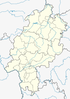
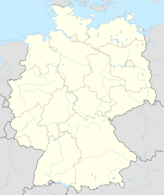
Main-Kinzig-Kreis is a Kreis (district) in the east of Hesse, Germany. Neighboring districts are Wetteraukreis, Vogelsbergkreis, Fulda, Bad Kissingen, Main-Spessart, Aschaffenburg, Offenbach and the district-free cities of Offenbach and Frankfurt.

<span class="mw-page-title-main">Hanau</span> City in Hesse, Germany

Hanau is a city in the Main-Kinzig-Kreis, in Hesse, Germany. It is located 25 km east of Frankfurt am Main and is part of the Frankfurt Rhine-Main Metropolitan Region. Its station is a major railway junction and it has a port on the river Main, making it an important transport centre. The city is known for being the birthplace of Jakob and Wilhelm Grimm and Franciscus Sylvius. Since the 16th century it was a centre of precious metal working with many goldsmiths. It is home to Heraeus, one of the largest family-owned companies in Germany.

<span class="mw-page-title-main">Gelnhausen</span> Town in Hesse, Germany

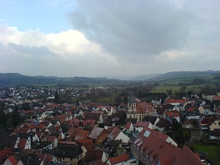
Gelnhausen is a town, and the capital of the Main-Kinzig-Kreis, in Hesse, Germany. It is located approximately 40 kilometers east of Frankfurt am Main, between the Vogelsberg mountains and the Spessart range at the river Kinzig. It is one of the eleven towns in the district. Gelnhausen has around 22,000 inhabitants.

<span class="mw-page-title-main">Seligenstadt</span> Town in Hesse, Germany

Seligenstadt is a town in the Offenbach district in the Regierungsbezirk of Darmstadt in Hesse, Germany. Seligenstadt is one of Germany's oldest towns and was already of great importance in Carolingian times.

<span class="mw-page-title-main">Kinzig (Main)</span> Right tributary of the Main in Hesse, Germany

The Kinzig is a river, 87 kilometres long, in southern Hesse, Germany. It is a right tributary of the Main. Its source is in the Spessart hills at Sterbfritz, near Schlüchtern. The Kinzig flows into the Main in Hanau. The Main-Kinzig-Kreis (district) was named after the river. The towns along the Kinzig are Schlüchtern, Steinau an der Straße, Bad Soden-Salmünster, Gelnhausen, and Hanau. The Kinzig is first recorded in 815 A.D. as Chinzicha.

<i>Kaiserpfalz</i> Palaces throughout the Holy Roman Empire which served as temporary seats for the Emperor

The term Kaiserpfalz or Königspfalz refers to a number of palaces and castles across the Holy Roman Empire that served as temporary seats of power for the Holy Roman Emperor in the Early and High Middle Ages.

<span class="mw-page-title-main">Barbarossa city</span> Nickname for five German cities

"Barbarossa city" is a nickname for German cities that the Staufer Emperor Frederick Barbarossa stayed in or near for some time. The cities usually mentioned include Sinzig, Kaiserslautern, Gelnhausen, Altenburg, Bad Frankenhausen, but Annweiler am Trifels, Bad Wimpfen, Eberbach and Waiblingen consider themselves as such as well.

<span class="mw-page-title-main">Freigericht</span> Municipality in Hesse, Germany

Freigericht is a municipality in the Main-Kinzig district, in Hesse, Germany. It is situated 15 km east of Hanau, close to the Frankfurt Rhein-Main region at the foothills of the Spessart, directly at the Hesse-Bavaria border. More than 40% of the area is forested.

<span class="mw-page-title-main">Steinau an der Straße</span> Town in Hesse, Germany

Steinau an der Straße is a town of around 10,000 inhabitants in the Main-Kinzig district, in Hesse, Germany. It is situated on the river Kinzig, 32 kilometres (20 mi) southwest of Fulda. The name Steinau refers to stones in the river; an der Straße, meaning on the road, refers to the historic trade route Via Regia from Leipzig to Frankfurt on which it was located. Steinau is best known for the Brothers Grimm who spent part of their childhood here.

<span class="mw-page-title-main">Flörsbachtal</span> Municipality in Hesse, Germany

Flörsbachtal is a municipality in the Main-Kinzig district, in Hesse, Germany. It has a population close to 2,400. Flösbachtal contains both the oldest parish and the youngest settlement established in the Spessart hills. Located within the municipal territory is the Hermannskoppe, the highest elevation in the Hessian part of the Spessart and the Wiesbüttmoor, a rare hanging bog.

<span class="mw-page-title-main">Frankfurt–Göttingen railway</span> Railway line in Germany

The Frankfurt–Göttingen railway is a continuously double track and electrified main line in Hesse and southern Lower Saxony, Germany. The line was initially built from Bebra towards Fulda by the Kurhessen State Railway. After the Prussian annexation of the Electorate of Hesse as a result of the Austro-Prussian War of 1866, it was completed to Frankfurt as the Frankfurt-Bebra Railway. The line was later extended from Bebra to Göttingen.

<span class="mw-page-title-main">Imperial castle</span>

An imperial castle or Reichsburg was a castle built by order of the King of the Romans or the Holy Roman Emperor on land that was owned by the crown (Reichsgut).

<span class="mw-page-title-main">Gelnhausen station</span>

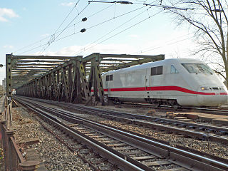
Gelnhausen station is the station of the town of Gelnhausen on the Frankfurt–Göttingen railway in the German state of Hesse.

<span class="mw-page-title-main">Wetterau Association of Imperial Counts</span>

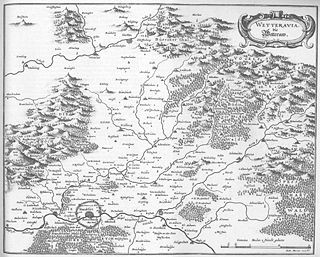
Wetterau Association of Imperial Counts was an association of comital families in the Wetterau and surrounding areas. It originated in the late Middle Ages and was formally disbanded when the Holy Roman Empire was dissolved in 1806.

<span class="mw-page-title-main">Langenselbold station</span> Railway station in Hesse, Germany

Langenselbold station is a station in the town of Langenselbold in the German state of Hesse on the Frankfurt–Göttingen railway. The station is classified by Deutsche Bahn (DB) as a category 4 station.

<span class="mw-page-title-main">Büdingen (Oberhess) station</span> Railway station in Hesse, Germany

Büdingen (Oberhess) station is a station on the Gießen–Gelnhausen railway in the town of Büdingen in the German state of Hesse. The station is located in the centre of the town. Büches-Düdelsheim station is also located in the municipality, in the district of Büches. The station is classified by Deutsche Bahn (DB) as a category 5 station.

The County of Hanau-Münzenberg was a territory within the Holy Roman Empire. It emerged when the County of Hanau was divided in 1458, the other part being the county of Hanau-Lichtenberg. Due to common heirs, both counties were merged from 1642 to 1685 and from 1712 to 1736. In 1736 the last member of the House of Hanau died and the Landgrave of Hessen-Kassel inherited the county.

<span class="mw-page-title-main">Ingelheim Imperial Palace</span>

The Ingelheim Imperial Palace was an important imperial palace erected in the second half of the 8th century in Germany. It served kings of Francia and later Holy Roman Emperors and Kings as a residenz and place for governance until the 11th century.

<span class="mw-page-title-main">Wildenberg Castle (Kirchzell)</span> Castle in Germany

Wildenberg Castle, also called the Wildenburg, is a ruined, Hohenstaufen period castle in the Odenwald hills in Germany. It is located in the parish of Preunschen in the municipality of Kirchzell, in the Lower Franconian district of Miltenberg in Bavaria.

<span class="mw-page-title-main">Ronneburg Castle</span> Castle in Hesse, Germany

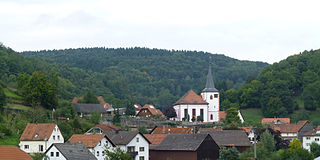
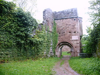
Ronneburg Castle is a castle in Ronneburg in the Main-Kinzig district of Hesse, Germany. It is a hilltop castle situated near the near Altwiedermus village on a steep basalt cone. Its position makes it visible from afar. It lends its name to the Ronneburg hill country.

References

  1. Binding, p. 45, plate 9.
  2. Binding, p. 60f.
  3. Fred Schwind: Reichsstadt und Kaiserpfalz Gelnhausen. In: Hans Patze (Ed.): Der Reichstag von Gelnhausen. Ein Markstein in der deutschen Geschichte 1180–1980. Marburg 1981, p. 73–95.
  4. Friedrich, p. 507; Cremer, p. 351.
  5. Hundeshagen, Bernhard: Kaiser Friedrichs I. Barbarossa Palast in der Burg zu Gelnhausen. Eine Urkunde vom Adel der von Hohenstaufen und der Kunstbildung ihrer Zeit, Mainz, 1819.
  6. Binding, p. 22.
  7. Binding, p. 23.
  8. Binding, p. 23–28, plates 5–7.
  9. Friedrich, p. 510.
  10. Friedrich, p. 509.
  11. Friedrich, p. 507; Cremer, p. 352.
  12. Friedrich, p. 508; Cremer, p. 352.
  13. Friedrich, p. 511.
  14. Cremer, p. 354.
  15. Binding, p. 26, plates 3, 4, 8.
  16. Hundeshagen, plate V.
  17. Binding, plate 8.
  18. Großmann, S. 233.
  19. Friedrich, p. 511; Binding, p. 29.
  20. Friedrich, p. 509.
  21. Binding, p. 28.
  22. Friedrich, p. 511.
  23. Cremer, p. 352.
  24. Binding, p. 27.
  25. Binding, p. 29.

Literature

50°12′0″N9°11′44″E / 50.20000°N 9.19556°E / 50.20000; 9.19556