
Cernusco sul Naviglio is a town and comune in the Metropolitan City of Milan, Lombardy, northwestern Italy. With a population of 33,436 as of 2015 it is the 14th-largest municipality in the metropolitan city.

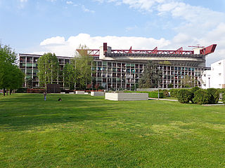
Brugherio is a comune (municipality) in the Province of Monza and Brianza in the Italian region Lombardy, located about 10 kilometres northeast of Milan. It was established December 9, 1866 unifying the suppressed municipalities of Baraggia, San Damiano and Moncucco, together with the villages of Bindellera, Cesena, Gelosa, San Paolo, Torazza, Occhiate and Increa.

Circeo National Park is an Italian national park founded in 1934. It occupies a strip of coastal land from Anzio to Terracina, including also a sector of forest in the mainland of San Felice Circeo, and the island of Zannone.

Quarto Cagnino is a district (quartiere) of Milan, Italy, part of the Zone 7 administrative division of the city. It borders the districts of Trenno (north), San Siro (east), Baggio (south), and Quinto Romano (west). Before being annexed to Milan, in 1869, it was an autonomous comune and, briefly, a part of Trenno.

Parco Papa Giovanni Paolo II, best known by its historic name Basilicas Park is a city park of Milan, Italy, located in Zone 1. It owes its name to the fact that it connects two major basilicas, the Basilica of San Lorenzo and the Basilica of Sant'Eustorgio. The park has an overall area of 40.700 m2, bisected by Via Molino delle Armi, one of the avenues comprising the Cerchia dei Navigli ring road.
The Zone 7 of Milan, since 2016 officially Municipality 7 of Milan, is one of the 9 administrative divisions of Milan, Italy.

The Parco delle Cascine (Cascine Park) is a monumental and historical park in the city of Florence. The park covers an area of 160 hectares. It has the shape of a long and narrow stripe, on the north bank of the Arno river. It extends from the centre of Florence until the point where the Mugnone flows into the Arno.

The Palazzo Ghirlanda-Silva is a patrician building in the old town of Brugherio in the region of Lombardy, Italy. Built in the first half of the nineteenth century, it now houses the public library. It has an area of 1,992 m2 (21,440 sq ft), of which 1,407 m2 (15,140 sq ft) are used for library services, with the remaining space providing an exhibition room, an auditorium and offices.
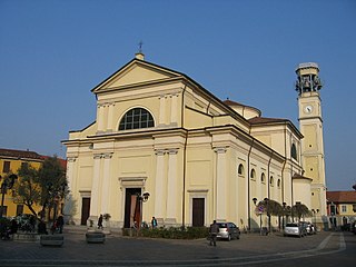
The Church of Saint Bartholomew is the cathedral and the oldest parish in Brugherio, Italy. It houses relics of the three Magi. It is characterised by its relatively high bell tower measuring 36.8 metres (121 ft).

Saint Lucius in Brugherio, Italy, is a small church dedicated to Saint Lucius in the grounds of the Villa Sormani. First located in Lugano, Switzerland, where it was a Franciscan chapel, the building was disassembled and transported to Brugherio, where its reconstruction was completed 17 years later.

Villa Scotti-Cornaglia-Noseda-Bertani, commonly known as Villa Fiorita, is a building in Lombardy, Italy, where the Brugherio Comune's headquarters are housed.

The church of Saint Mary Immaculate is a church that is annexed to Cascina Increa, next to the entrance of Villa Tizzoni Ottolini in Brugherio. The church has undergone renovations, however, like the farmhouse to which it is attached, has maintained its original architecture. Increa, the area where the church is located, formerly belonged to the municipality of Cernusco Asinario ; it became part of the parish of Saint Bartholomew in 1578 and was subsequently annexed to the municipality of Brugherio in 1866.

Cascina Increa is one of the farmhouses of Brugherio, on the southeastern border of the municipality. It enjoys the protection of the Soprintendenze per i Beni Architettonici e Paesaggistici, i.e., the Ministry of Cultural Heritage and Activities and Tourism (MiBACT) of its respective province because of its surviving Renaissance architecture.

Villa Tizzoni Ottolini is located in the architectural complex of Cascina Increa, in southeast Brugherio, Italy.

Cascina Sant'Ambrogio is the oldest among the farmhouses in Brugherio, Italy. It is annexed to Saint Ambrose Church from which it takes its name.

Cassina Baraggia is a hamlet of Brugherio's municipality, which until 1866 was a separate municipality.
The old farmhouses of Brugherio were agricultural structures typical of the Po-Valley in Lombardy, which gave its name to the surrounding areas as well, roughly corresponding to fractional towns in which Brugherio was divided. The union of the various small rural municipalities in which the territory was fragmented gave birth in 1866 to the municipality of Brugherio. Some are still visible: Bindellera, Casecca, Cattoni, Comolli, Dorderio, Guzzina, Increa, Modesta, Moia, Occhiate, Pareana, San Cristoforo, Sant'Ambrogio, San Paolo and Torazza.
St. Paul's Church is a church dedicated to St. Paul the Apostle located in the south of Brugherio. It is part of the pastoral community Epiphany of the Lord.
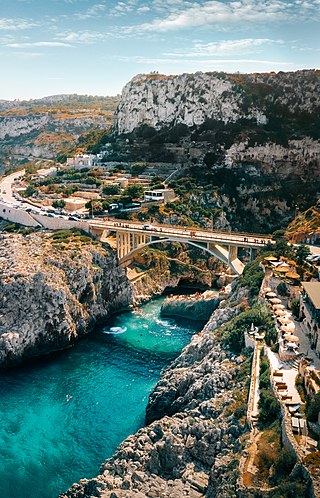
Ciolo is a narrow coastal inlet and a site of historical and environmental interest, which is located in the south of Apulia, in the historical region of Salento, Italy. The location is also known as a geological site and for the presence of numerous sea caves, the largest one being the Grotta del Ciolo. Since October 2006 the Ciolo's area has become part of the Regional Park "Costa Otranto - Santa Maria di Leuca e Bosco di Tricase", created by the Apulia region to protect the eastern coast of Salento, specifically the architectural assets as well as important animal and plant species.
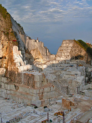
No Cav is an Italian protest movement that arose in the early 21st century, criticising the Carrara marble quarries in the Apuan Alps.


