Related Research Articles

Monroe County is a county in the U.S. state of West Virginia. As of the 2020 census, the population was 12,376. Its county seat is Union. Monroe County was the home of Andrew Summers Rowan of Spanish–American War fame, who is immortalized in Elbert Hubbard's classic A Message to Garcia. The county was also the site of the 1928 discovery of the 34.48 carat Jones Diamond by Grover C. Jones and William "Punch" Jones. Monroe County celebrates its own holiday, Farmers' Day.

Monroe County is a county located on the eastern border of the U.S. state of Tennessee. As of the 2020 census, the population was 46,250. Its county seat is Madisonville, and its largest city is Sweetwater.

Union County is a county located in the U.S. state of North Carolina. As of the 2020 census, the population was 238,267. Its county seat is Monroe. Union County is included in the Charlotte-Concord-Gastonia, NC-SC Metropolitan Statistical Area.

Monroe County is a county in the U.S. state of Indiana. In 1910 the US Census Bureau calculated the nation's mean population center to lie in Monroe County. The population was 139,718 at the 2020 United States Census. The county seat is Bloomington. Monroe County is part of the Bloomington, Indiana, Metropolitan Statistical Area.
Indian Creek may refer to the following:
Sleepy Creek is a 44.0-mile-long (70.8 km) tributary of the Potomac River in the United States, belonging to the Chesapeake Bay's watershed. The stream rises in Frederick County, Virginia, and flows through Morgan County, West Virginia before joining the Potomac near the community of Sleepy Creek.

Indian Mound Cemetery is a cemetery located along the Northwestern Turnpike on a promontory of the "Yellow Banks" overlooking the South Branch Potomac River and Mill Creek Mountain in Romney, West Virginia, United States. The cemetery is centered on a Hopewellian mound, known as the Romney Indian Mound. Indian Mound Cemetery is also the site of Fort Pearsall, the Confederate Memorial, Parsons Bell Tower, and reinterments from Romney's Old Presbyterian Cemetery. The cemetery is currently owned and maintained by the Indian Mound Cemetery Association, Inc.

This is a list of properties and historic districts in West Virginia that are listed on the National Register of Historic Places. There are listings in every one of West Virginia's 55 counties.

Virginia State Route 311 and West Virginia Route 311 are adjoining state highways in the U.S. states of Virginia and West Virginia. The two state highways together run 58.7 miles (94.5 km) from U.S. Route 11 in Salem, Virginia north to Interstate 64 and U.S. Route 60 near White Sulphur Springs, West Virginia. The two Virginia portions of Route 311 are maintained by the Virginia Department of Transportation, with the exception of the city-maintained portion within Salem. The West Virginia segments are maintained by the West Virginia Division of Highways.

State Route 205 is a primary state highway in the U.S. state of Virginia. The state highway runs 18.47 miles (29.72 km) from SR 3 at Purkins Corner east to SR 3 at Oak Grove. SR 205 connects several small communities in eastern King George County and northwestern Westmoreland County. The state highway also passes through the Potomac River resort of Colonial Beach, where the highway has a spur, State Route 205Y.
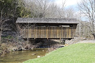
The Indian Creek Covered Bridge is a historic covered bridge near US 219, about 4 miles away from Salt Sulphur Springs, in Monroe County, West Virginia, United States. It is owned by the Monroe County Historical Society, and was originally built in 1898 by Ray and Oscar Weikel. The bridge is 49.25 feet long and 11.5 feet wide.
Red Sulphur Springs is an unincorporated community in Monroe County, West Virginia, United States. It once boasted the Red Sulphur Springs Hotel. Red Sulphur Springs is located on West Virginia Route 12, close to Indian Creek.

Little Indian Creek Wildlife Management Area is located on 1,036 acres (419 ha) southwest of Westover in Monongalia County, West Virginia. The wildlife management area is centered on reclaimed former coal mine land along Little Indian Creek, a tributary of the Monongahela River.
Indian Creek, is a tributary of the New River, flowing through the state of West Virginia in the United States.

Paint Bank is an unincorporated community in northern Craig County, Virginia, United States. It is located at the intersection of State Route 18 and State Route 311 northwest of the town of New Castle, the county seat. The village is located between Potts Mountain and Peters Mountain. It is one of the westernmost communities of the Roanoke metropolitan area.
The Appomattoc were a historic tribe of Virginia Indians speaking an Algonquian language, and residing along the lower Appomattox River, in the area of what is now Petersburg, Colonial Heights, Chesterfield and Dinwiddie Counties in present-day southeast Virginia.

Byrnside-Beirne-Johnson House, also known as "Willowbrook," is a historic home located near Union, Monroe County, West Virginia. The house began as a pioneer log fort built by six families in 1770. After 1855, it was enlarged to a large 2+1⁄2-story, five-bay, T-shaped dwelling with a two-story rear wing. It is covered with board-and-batten siding in the Gothic Revival style. The front features a two-story gable end porch built about 1900. Also on the property is a contributing smokehouse.
Maryland Ridge in Indiana was an unincorporated community of settlers from Calvert County, Maryland, in the early 19th century. The settlers came to Indiana after the War of 1812 in successive waves between 1818 and 1839. One community where they settled became known as Maryland Ridge. The geographic area follows the ridges and streams of Indian Creek along the Monroe-Greene County line.

Alexander W. Monroe was a prominent American lawyer, politician, and military officer in the U.S. states of Virginia and West Virginia. Monroe served as a member of the Virginia House of Delegates and West Virginia House of Delegates representing Hampshire County. He was the Speaker of the West Virginia House of Delegates during the 1875–1877 legislative session. Monroe also represented Hampshire County in the West Virginia Constitutional Convention of 1872.
References
Municipalities and communities of Monroe County, West Virginia, United States | ||
|---|---|---|
| Towns |  | |
| Unincorporated communities |
| |
| Ghost town | ||
| Footnotes | ‡This populated place also has portions in an adjacent county or counties | |
| | This article about a location in Monroe County, West Virginia is a stub. You can help Wikipedia by expanding it. |