
Phoebus is an incorporated town located in present day Hampton, Virginia on the Virginia Peninsula. In 1900, it was named in honor of local businessman Harrison Phoebus (1840–1886), who is credited with convincing the Chesapeake and Ohio Railway (C&O) to extend its tracks to the town from Newport News.
Monroe is an unincorporated community in Amherst County, Virginia, United States. Monroe is located along U.S. Route 29 6.1 miles (9.8 km) north of Lynchburg.
The Cherokee Path was the primary route of English and Scots traders from Charleston to Columbia, South Carolina in Colonial America. It was the way they reached Cherokee towns and territories along the upper Keowee River and its tributaries. In its lower section it was known as the Savannah River. They referred to these towns along the Keowee and Tugaloo rivers as the Lower Towns, in contrast to the Middle Towns in Western North Carolina and the Overhill Towns in present-day southeastern Tennessee west of the Appalachian Mountains.

Capon Chapel, also historically known as Capon Baptist Chapel and Capon Chapel Church, is a mid-19th century United Methodist church located near to the town of Capon Bridge, West Virginia, in the United States. Capon Chapel is one of the oldest existing log churches in Hampshire County, along with Mount Bethel Church and Old Pine Church.

Aldie is an unincorporated community and census-designated place (CDP) located between Chantilly and Middleburg in Loudoun County, Virginia, United States. The historic village of Aldie is located on the John Mosby Highway in a gap between the Catoctin Mountains and Bull Run Mountains, through which the Little River flows. Aldie traditionally serves as the gateway to the Loudoun Valley and beyond.

This is a list of properties and historic districts in West Virginia that are listed on the National Register of Historic Places. There are listings in every one of West Virginia's 55 counties.
Files Crossroad is an unincorporated community in Berkeley County, West Virginia, United States. The community is located east of Martinsburg on West Virginia Route 45 at its crossroads with County Route 45/4. The community was originally known as Smoketown, hence the name of its historic Smoketown Cemetery.

London is an unincorporated community in Kanawha County in the U.S. state of West Virginia, located 25 miles from the state capital of Charleston. London Lock and Dam, operated by US Army Corps of Engineers is located here on Kanawha River.

This is a list of the National Register of Historic Places listings in Monroe County, West Virginia.
Lowell is an unincorporated community in Summers County, West Virginia, United States. Lowell is located on the Greenbrier River, east of Hinton and southwest of Alderson. The community was first settled in 1770 and is the oldest community in Summers County.
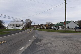
Pickaway is an unincorporated community in Monroe County, West Virginia, United States. Pickaway is located on U.S. Route 219, northeast of Union.

Salt Sulphur Springs is an unincorporated community in Monroe County, West Virginia, United States. Salt Sulphur Springs is located on U.S. Route 219, southwest of Union.
Quiet Dell is an unincorporated community in Harrison County, West Virginia, United States. Quiet Dell is located at the junction of Interstate 79 and West Virginia Route 20, 5 miles (8.0 km) southeast of Clarksburg.
Miller–Pence Farm is a historic home and farm located near Greenville, Monroe County, West Virginia. The main farmhouse was built in 1828, with five modifications through 1910. It began as a two-story Federal style brick home on a coursed rubble foundation. A two-story addition dated to the 1880s, with a cut stone foundation, has board-and-batten siding, evoking the Carpenter Gothic architectural style. Also on the property are a former slave school, second school, three barns, tractor shed, equipment shed, corn crib and ruins of Miller's Frontier House, spring box, original road cut, and the Miller-Halstead Cemetery.
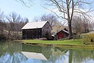
Cook's Mill, also known as The Old Mill and The Greenville Mill, is a historic grist mill and sawmill and national historic district located near Greenville, Monroe County, West Virginia, United States. The district includes one contributing buildings and two contributing structures. The main mill building was built in 1857 on the original stone foundation and site of an earlier mill built in approximately 1796. It is a 2+1⁄2-story, plus basement, hand-hewn post-and-beam building, with massive timbers pegged at their mortise and tenon joints. The district also includes the dam, mill pond, tail race and stream.

Monroe Street East Historic District is a national historic district located at Wheeling, Ohio County, West Virginia. The district encompasses six contributing buildings. They are a Greek Revival style church built in 1837, a Roman-Tuscan style dwelling dated to 1852 and known as the Paxton-Reed House, and an eclectic 1881 dwelling. Also in the district is a Richardsonian Romanesque style apartment building and a set of vernacular post-American Civil War townhouses.

East Wheeling Historic District is a national historic district located at Wheeling, Ohio County, West Virginia. The district encompasses 300 contributing buildings and one contributing site, including the Monroe Street East Historic District. The district is primarily residential, developed in the late-19th and early-20th century. A number of popular architectural styles are represented including Greek Revival and Gothic Revival. Notable non-residential buildings include St. Joseph Cathedral (1926), former Hazel Atlas Company building, Scottish Rite Temple designed by noted Wheeling architect Frederick F. Faris (1870-1927), Elks Building, and YMCA (1906), also designed by Faris. The contributing site is Elk Playground. Also located in the district are the separately listed L. S. Good House, Charles W. Russell House, and Cathedral Parish School.
Cranesville is an unincorporated community in Preston County, West Virginia, United States. Cranesville is located along County Route 47, 7.9 miles (12.7 km) north-northeast of Terra Alta.
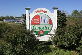
Conestee is an unincorporated community and census-designated place (CDP) in Greenville County, South Carolina, United States. It was first listed as a CDP in the 2020 census with a population of 904.

Reaville is an unincorporated community located along the border of East Amwell and Raritan townships in Hunterdon County, New Jersey. By the 1830s, it was known as Greenville. It was later renamed after Runkle Rea, the first postmaster in 1850.


