Related Research Articles

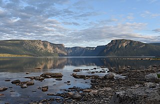
Gros Morne National Park is a Canadian national park and World Heritage Site located on the west coast of Newfoundland. At 1,805 km2 (697 sq mi), it is the second largest national park in Atlantic Canada after Torngat Mountains National Park, which has an area of 9,700 km2 (3,700 sq mi).

Cape Breton Highlands National Park is a Canadian national park on northern Cape Breton Island in Nova Scotia. The park was the first national park in the Atlantic provinces of Canada and covers an area of 948 square kilometres (366 sq mi). It is one of 42 in Canada's system of national parks.
The Howgill Fells are uplands in Northern England between the Lake District and the Yorkshire Dales, lying roughly within a triangle formed by the town of Sedbergh and the villages of Ravenstonedale and Tebay. The name Howgill derives from the Old Norse word haugr meaning a hill or barrow, plus gil meaning a narrow valley.
The geology of the county of Shropshire, England is very diverse with a large number of periods being represented at outcrop. The bedrock consists principally of sedimentary rocks of Palaeozoic and Mesozoic age, surrounding restricted areas of Precambrian metasedimentary and metavolcanic rocks. The county hosts in its Quaternary deposits and landforms, a significant record of recent glaciation. The exploitation of the Coal Measures and other Carboniferous age strata in the Ironbridge area made it one of the birthplaces of the Industrial Revolution. There is also a large amount of mineral wealth in the county, including lead and baryte. Quarrying is still active, with limestone for cement manufacture and concrete aggregate, sandstone, greywacke and dolerite for road aggregate, and sand and gravel for aggregate and drainage filters. Groundwater is an equally important economic resource.

Ingleton is a village and civil parish in North Yorkshire, England. The village is 17 miles (27 km) from Kendal and 17 miles (27 km) from Lancaster on the western side of the Pennines. It is 9 miles (14 km) from Settle. The River Doe and the River Twiss meet to form the source of the River Greta, a tributary of the River Lune. The village is on the A65 road and at the head of the A687. The B6255 takes the south bank of the River Doe to Ribblehead and Hawes. All that remains of the railway in the village is the landmark Ingleton Viaduct. Arthur Conan Doyle was a regular visitor to the area and was married locally, as his mother lived at Masongill from 1882 to 1917. It has been claimed that there is evidence that the inspiration for the name Sherlock Holmes came from here.

The Caledonian orogeny was a mountain-building cycle recorded in the northern parts of the British Isles, the Scandinavian Caledonides, Svalbard, eastern Greenland and parts of north-central Europe. The Caledonian orogeny encompasses events that occurred from the Ordovician to Early Devonian, roughly 490–390 million years ago (Ma). It was caused by the closure of the Iapetus Ocean when the Laurentia and Baltica continents and the Avalonia microcontinent collided.

The geology of Wales is complex and varied; its study has been of considerable historical significance in the development of geology as a science. All geological periods from the Cryogenian to the Jurassic are represented at outcrop, whilst younger sedimentary rocks occur beneath the seas immediately off the Welsh coast. The effects of two mountain-building episodes have left their mark in the faulting and folding of much of the Palaeozoic rock sequence. Superficial deposits and landforms created during the present Quaternary period by water and ice are also plentiful and contribute to a remarkably diverse landscape of mountains, hills and coastal plains.

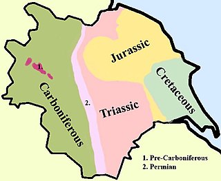
The Geology of Yorkshire in northern England shows a very close relationship between the major topographical areas and the geological period in which their rocks were formed. The rocks of the Pennine chain of hills in the west are of Carboniferous origin whilst those of the central vale are Permo-Triassic. The North York Moors in the north-east of the county are Jurassic in age while the Yorkshire Wolds to the south east are Cretaceous chalk uplands. The plain of Holderness and the Humberhead levels both owe their present form to the Quaternary ice ages. The strata become gradually younger from west to east.
An inlier is an area of older rocks surrounded by younger rocks. Inliers are typically formed by the erosion of overlying younger rocks to reveal a limited exposure of the older underlying rocks. Faulting or folding may also contribute to the observed outcrop pattern. A classic example from Great Britain is that of the inlier of folded Ordovician and Silurian rocks at Horton in Ribblesdale in North Yorkshire which are surrounded by the younger flat-lying Carboniferous Limestone. The location has long been visited by geology students and experts. Another example from South Wales is the Usk Inlier in Monmouthshire where Silurian age rocks are upfolded amidst Old Red Sandstone rocks of Devonian age.

For the Skiddaw group of hills, see Skiddaw Group

The geology of the Isle of Skye in Scotland is highly varied and the island's landscape reflects changes in the underlying nature of the rocks. A wide range of rock types are exposed on the island, sedimentary, metamorphic and igneous, ranging in age from the Archaean through to the Quaternary.

The Dent Group is a group of Upper Ordovician sedimentary and volcanic rocks in north-west England. It is the lowermost part of the Windermere Supergroup, which was deposited in the foreland basin formed during the collision between Laurentia and Avalonia. It lies unconformably on the Borrowdale Volcanic Group. This unit was previously known as the Coniston Limestone Group or Coniston Limestone Formation and should not be confused with the significantly younger Coniston Group.
The Eycott Volcanic Group is a group of volcanic rock formations of Ordovician age named after the locality of Eycott Hill in the English Lake District. The group overlies the Skiddaw Group and is unconformably overlain by a variety of different Devonian and Carboniferous age rocks.

The Causey Pike Fault or Causey Pike Thrust is a major WSW-ENE trending fault within the Lower Paleozoic rocks of the English Lake District. It is named for Causey Pike, where the fault was first recognised.

The geology of England's Lake District is dominated by sedimentary and volcanic rocks of mainly Ordovician age underpinned by large granitic intrusions. Younger sedimentary sequences outcrop on the edges of the Lake District area, with Silurian to the south, Carboniferous to the north, east, and west and Permo-Triassic to the west and east. The entire area was covered by a Mesozoic sequence that was eroded off during the Paleogene uplift related to the opening of the North Atlantic. During the Quaternary the area was affected by repeated glaciations, which sculpted the current mountainous landscape.
The geology of Loch Lomond and The Trossachs National Park in the southwestern part of the Scottish Highlands consists largely of Neoproterozoic and Palaeozoic bedrock faulted and folded and subjected to low grade metamorphism during the Caledonian orogeny. These older rocks, assigned to the Dalradian Supergroup, lie to the northwest of the northeast – southwest aligned Highland Boundary Fault which defines the southern edge of the Highlands. A part of this mountainous park extends south of this major geological divide into an area characterised by younger Devonian rocks which are assigned to the Old Red Sandstone.

The geology of Snowdonia National Park in North Wales is dominated by sedimentary and volcanic rocks from the Cambrian and Ordovician periods with intrusions of Ordovician and Silurian age. There are Silurian and Cenozoic sedimentary rocks on the park's margins. The succession was intensely faulted and folded during the Caledonian Orogeny. The region was uplifted as the North Atlantic Ocean opened during the Cenozoic. The current mountainous landscape arises from repeated glaciations during the Quaternary period.
The bedrock geology of Ceredigion in west Wales consists wholly of a considerable thickness of Ordovician and Silurian age sedimentary rocks of marine origin. Unconsolidated deposits of Quaternary age include a widespread cover of glacial till, valley floor alluvium and scattered peat deposits in both upland and lowland settings.
The geology of the Yorkshire Dales National Park in northern England largely consists of a sequence of sedimentary rocks of Ordovician to Permian age. The core area of the Yorkshire Dales is formed from a layer-cake of limestones, sandstones and mudstones laid down during the Carboniferous period. It is noted for its karst landscape which includes extensive areas of limestone pavement and large numbers of caves including Britain's longest cave network.
The geology of Pembrokeshire in Wales inevitably includes the geology of the Pembrokeshire Coast National Park which extends around the larger part of the county's coastline and where the majority of rock outcrops are to be seen. The park was established as a national park in 1952. Pembrokeshire's bedrock geology is largely formed from a sequence of sedimentary and igneous rocks originating during the late Precambrian and the Palaeozoic era, namely the Ediacaran, Cambrian, Ordovician, Silurian, Devonian and Carboniferous periods, i.e. between 635 and 299 Ma. The older rocks in the north of the county display patterns of faulting and folding associated with the Caledonian Orogeny. On the other hand, the late Palaeozoic rocks to the south owe their fold patterns and deformation to the later Variscan Orogeny.
References
- ↑ "Ingleton Group". The BGS Lexicon of Named Rock Units. British Geological Survey. Retrieved 25 September 2021.
- ↑ "Geoindex Onshore". British Geological Survey. Retrieved 25 September 2021.