
Gildeskål is a municipality in Nordland county, Norway. It is part of the Bodø Region and the traditional district of Salten. The administrative centre of the municipality is the village of Inndyr. Other villages include Forstranda, Lekanger, Mevik, Mårnes, Nygårdsjøen, Saura, Storvik, Sør-Arnøy, Sørfinnset, and Våg.

(Norwegian) or Ánddanjárga (Northern Sami) is the administrative centre of Andøy Municipality which is located in the Vesterålen district of Nordland county, Norway. The village of Andenes is the northernmost settlement of the island of Andøya.
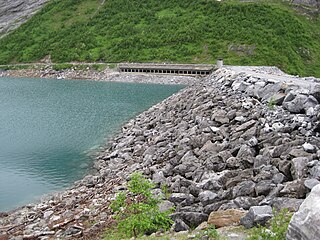
Arstaddalsdammen is a lake that lies in Beiarn Municipality in Nordland county, Norway. It is located about 15 kilometres (9.3 mi) southwest of the village of Moldjord. The 2.54-square-kilometre (0.98 sq mi) lake lies in the southern end of the Arstaddal valley, and it has a dam on the northern end. The dam was built in the 1960s. The water from the lake is piped to the nearby lake Sokumvatnet in Gildeskål Municipality. The lake serves as a reservoir for the Sundsfjord Hydroelectric Power Station.
Langvatnet (Norwegian) or Gåddumjávrre (Lule Sami) is a lake that lies in Gildeskål Municipality in Nordland county, Norway. The lake is located about 15 kilometres (9.3 mi) southeast of the municipal centre of Inndyr. It sits directly southwest of the large lake Sokumvatnet. The lake is partially supplied by discharge from the Langvann Hydroelectric Power Station and serves as a reservoir for the Sundsfjord Hydroelectric Power Station.
Lysvatnet is a lake that lies in the municipality of Meløy in Nordland county, Norway. The 4.53-square-kilometre (1.75 sq mi) is located near the border with Gildeskål Municipality, about 5.5 kilometres (3.4 mi) east of the municipal centre of Ørnes. The lake Markavatnet lies about 3 kilometres (1.9 mi) to the west of this lake.
Sokumvatnet (Norwegian) or Såhkamjávrre (Lule Sami) is a lake that lies in Gildeskål Municipality in Nordland county, Norway. Sokumvatnet is located about 15 kilometres (9.3 mi) southeast of the village of Inndyr. It lies just south of the lake Litle Sokumvatnet and northeast of the lake Langvatnet. The lake serves as a reservoir for the Sundsfjord Hydroelectric Power Station.
Valnesvatnet is a lake that lies in Bodø Municipality in Nordland county, Norway. The 4.91-square-kilometre (1.90 sq mi) lake lies along the Norwegian County Road 17 about 1 kilometre (0.62 mi) north of the border with Gildeskål Municipality, just northeast of the village of Nygårdsjøen. The water in the lake flows out over the Valnesfossen waterfall on its way to the sea.

Gravdal is a village in Vestvågøy Municipality in Nordland county, Norway. It is located on the island of Vestvågøya in the central part of the Lofoten archipelago, north of the Arctic Circle. The village is situated along the shore of the Buksnesfjorden, about 3 kilometres (1.9 mi) southwest of the town of Leknes. The village also lies approximately 72 kilometres (45 mi) west of the town of Svolvær and 63 kilometres (39 mi) east of the village of Å in Moskenes Municipality. Historically, the village was the administrative centre of the old Buksnes Municipality which existed from 1838 until 1963.

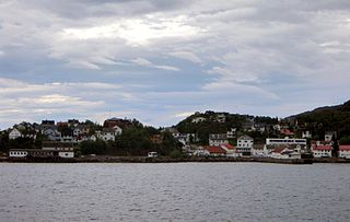
Sør-Arnøy is a small fishing village in Gildeskål Municipality in Nordland county, Norway. The village covers the majority of the island of Sør-Arnøya. The closest town to Sør-Arnøy is Bodø, which is located about 25 kilometres (16 mi) to the northeast on the mainland.

Kjøpsvik (Norwegian) or Gásluokta (Lule Sami) is a village in Narvik Municipality in Nordland county, Norway. The village is located on the eastern shore of the Tysfjorden, north of the small village of Storå. The island of Hulløya lies off the coast of Kjøpsvik. The 0.97-square-kilometre (240-acre) village has a population (2023) of 780 and a population density of 894 inhabitants per square kilometre (2,320/sq mi).
Tjøtta is a village in Alstahaug Municipality in Nordland county, Norway. It is located on the southern tip of the island of Tjøtta, which is located south of the large island of Alsta. The village is located on an island, but it does have a mainland road connection via Norwegian County Road 17 and a series of bridges heading north to the town of Sandnessjøen. The historic Tjøtta Church is located in the village.

Storvik is a village in Gildeskål Municipality in Nordland county, Norway. The village is located in the southern part of the municipality, about 4 kilometres (2.5 mi) northeast of the village of Mevik and about 10 kilometres (6.2 mi) west of Sørfinnset. The village is located along Norwegian County Road 17, at the western end of the 3,118-metre (10,230 ft) long Storvikskar Tunnel.
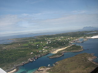
Sør-Arnøya is a small island in Gildeskål Municipality in Nordland county, Norway. The 4-square-kilometre (1.5 sq mi) island is located west of the neighboring island of Sandhornøya and south of the island of Nord-Arnøya. Sør-Arnøya and Nord-Arnøya are linked with a 100-metre (330 ft) long bridge.
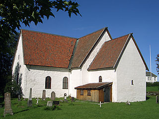
Old Gildeskål Church is a historic parish church of the Church of Norway in Gildeskål Municipality in Nordland county, Norway. It is located just north of the village of Inndyr. Before 1881, it was the main church for the Gildeskål parish which is part of the Bodø domprosti (deanery) in the Diocese of Sør-Hålogaland. The white, stone church was built in a long church style in the 12th century. The church seats about 275 people.

Gildeskål Church is a parish church of the Church of Norway in Gildeskål Municipality in Nordland county, Norway. It is located just north of the village of Inndyr. It is the main church for the Gildeskål parish which is part of the Bodø domprosti (deanery) in the Diocese of Sør-Hålogaland. The orange-colored, wooden, neo-gothic church was built in a long church style in 1881 using plans drawn up by the architect Carl J. Bergstrøm. The church seats about 750 people.
Mevik is a village in Gildeskål Municipality in Nordland county, Norway. It is located in the southwestern part of the municipality, about 4 kilometres (2.5 mi) west of the village of Storvik and about 10 kilometres (6.2 mi) northeast of the village of Reipå. The village is located along Norwegian County Road 17. Mevik Chapel is located in the village.
Sørfinnset is a village in Gildeskål Municipality in Nordland county, Norway. It is located on the mainland, south of the village of Inndyr and east of the village of Storvik. Norwegian County Road 17 passes by 2 kilometres (1.2 mi) south of the village. Sørfjorden Chapel is located in the village.
(Norwegian) or Fuossko (Lule Sami) is a town in Fauske Municipality in Nordland county, Norway. It is also the administrative centre of Fauske Municipality. The town is located on the shore of the Skjerstad Fjord, about 60 kilometres (37 mi) east of the town of Bodø and about 40 kilometres (25 mi) west of the border with Sweden. The lake Nervatnet lies on the southeast side of the town.
Lødingen (Norwegian) or Lodegak (Northern Sami) is the administrative centre of Lødingen Municipality in Nordland county, Norway. The village is located on the southwestern shore of the island of Hinnøya. The village is also located where the southern mouth of the Tjeldsundet strait meets the Vestfjorden.

Røstlandet is the administrative centre of Røst Municipality in Nordland county, Norway. The fishing village covers the southeastern half of the island of Røstlandet. Røst Airport is located on the northern part of the island. Røst Church is located in the village and serves the people of Røst Municipality.


