Geography
Location
The Innerste Uplands cover the catchment area of the Innerste southeast of Hildesheim and southwest to south of Salzgitter as far as Goslar and Seesen on the northwestern edge of the Harz. To the north the area is bounded by the Hildesheim Börde, to the west by the Leine Uplands and to the southeast by the North Harz Foreland. Its central and southern areas are dominated by the Ambergau, a depression dissected by the Nette, a tributary of the Innerste.

A drainage basin is any area of land where precipitation collects and drains off into a common outlet, such as into a river, bay, or other body of water. The drainage basin includes all the surface water from rain runoff, snowmelt, and nearby streams that run downslope towards the shared outlet, as well as the groundwater underneath the earth's surface. Drainage basins connect into other drainage basins at lower elevations in a hierarchical pattern, with smaller sub-drainage basins, which in turn drain into another common outlet.

Hildesheim[ˈhɪldəsˌhaɪ̯m](listen) is a city in Lower Saxony, Germany with 103,804 inhabitants. It is in the district of Hildesheim, about 30 km (19 mi) southeast of Hanover on the banks of the Innerste River, a small tributary of the Leine River. With the Hildesheim Cathedral and the St. Michael's Church Hildesheim has become a UNESCO World Heritage site in 1985.

Salzgitter is an independent city in southeast Lower Saxony, Germany, located between Hildesheim and Braunschweig. Together with Wolfsburg and Braunschweig, Salzgitter is one of the seven Oberzentren of Lower Saxony. With 101,079 inhabitants and 223.92 square kilometres (86.46 sq mi), its area is the largest in Lower Saxony and one of the largest in Germany. Salzgitter originated as a conglomeration of several small towns and villages, and is today made up of 31 boroughs, which are relatively compact conurbations with wide stretches of open country between them. The main shopping street of the young city is in the borough of Lebenstedt, and the central business district is in the borough of Salzgitter-Bad. The city is connected to the Mittellandkanal and the Elbe Lateral Canal by a distributary. The nearest metropolises are Braunschweig, about 23 kilometres to the northeast, and Hanover, about 51 km to the northwest. The population of the City of Salzgitter has exceeded 100,000 inhabitants since its foundation in 1942, when it was still called Watenstedt-Salzgitter. Beside Wolfsburg, Leverkusen and Eisenhüttenstadt, Salzgitter is therefore one of the few cities in Germany founded during the 20th century.
In and around the Innerste Uplands there are the following clearly defined ridges, most of which are cuestas and some of which lie on the boundary with neighbouring landscape regions (listed in alphabetical order): Giesen Hills, Hainberg, Harplage, Heber, Hildesheim Forest, Salzgitter Ridge (including the Lichtenberge), Sauberge and Vorholz. Between these ridges run the following rivers: Innerste, Lamme, Neile and Nette together with their tributaries.

A cuesta is a hill or ridge with a gentle slope on one side, and a steep slope on the other. In geology the term is more specifically applied to a ridge where a harder sedimentary rock overlies a softer layer, the whole being tilted somewhat from the horizontal. This results in a long and gentle backslope called a dip slope that conforms with the dip of resistant strata, called caprock. Where erosion has exposed the frontslope of this, a steep slope or escarpment occurs. The resulting terrain may be called scarpland.
The Giesen Hills are a ridge, up to 162.6 metres high, in the district of Hildesheim in the German state of Lower Saxony.
The Harplage is a hill range, up to 290 metres high, located west-northwest of the Harz in the southeast of the German state of Lower Saxony.
Description
The ridges of the Innerste Uplands are predominantly covered with deciduous forest, particularly beech woods. The rivers run through gently rolling depressions, covered with a thick layer of loess; this includes the basin of the Ambergau. The fertile soils are heavily used for arable farming. Also part of the landscape are quarries or open-cast mines, nowadays largely closed and sometimes filled with water, in which Keuper sandstone was extracted during the Middle Ages.
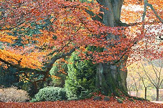
Beech (Fagus) is a genus of deciduous trees in the family Fagaceae, native to temperate Europe, Asia, and North America.

Loess is a clastic, predominantly silt-sized sediment that is formed by the accumulation of wind-blown dust. Ten percent of the Earth's land area is covered by loess or similar deposits.
The Keuper is a lithostratigraphic unit in the subsurface of large parts of west and central Europe. The Keuper consists of dolostone, shales or claystones and evaporites that were deposited during the Middle and Late Triassic epochs. The Keuper lies on top of the Muschelkalk and under the predominantly Lower Jurassic Lias or other Early Jurassic strata.
Hills and mountains
Eight ridges belong to the Innerste Uplands. They are, in order of height:
 The Hildesheim Forest is a range of hills up to 359 m above sea level (NN) in the district of Hildesheim in the German state of Lower Saxony.  Normalnull or Normal-Null is an outdated official vertical datum used in Germany. Elevations using this reference system were to be marked "Meter über Normal-Null". Normalnull has been replaced by Normalhöhennull.  The Salzgitter Hills is an area of upland up to 322.9 metres (1,059 ft) in height, in the Lower Saxon Hills between Salzgitter and Goslar in the districts of Wolfenbüttel and Goslar and in the territory of the independent town of Salzgitter. The hills lie in the German federal state of Lower Saxony. | |
The highest elevation in the Innerste Uplands is the 359 m high Griesberg in the Hildesheim Forest.
Rivers
The rivers of the Innerste Uplands are:
- Alme - in the west, of the Riehe
- Beuster - in the northwest, tributary of the Innerste
- Innerste - in the north, northeast and east, tributary of the Leine
- Lamme - in the west, tributary of the Innerste
- Neile - in the central southeast, tributary of the Innerste
- Nette - in the centre (Ambergau), tributary of the Innerste
- Riehe - in the west, tributary of the Lamme
Towns and villages
The following towns and villages lie within the Innerste Uplands or around its edge:
This page is based on this
Wikipedia article Text is available under the
CC BY-SA 4.0 license; additional terms may apply.
Images, videos and audio are available under their respective licenses.
Hildesheim is a district (Landkreis) in Lower Saxony, Germany. It is bounded by the districts of Hanover, Peine, Wolfenbüttel, Goslar, Northeim, Holzminden and Hamelin-Pyrmont.

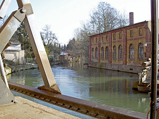
Nette is a river in Lower Saxony, Germany, a left tributary of the Innerste.
The Hildesheim Börde is a natural region, 272 km2 in area, in the northern part of Hildesheim district, which is known for its especially rich black earth loess soil.

The Vorholz is a ridge up to 243 m high in the districts of Hildesheim and Wolfenbüttel in the German state of Lower Saxony.

The Leine Uplands is a region in Germany's Central Uplands which forms a part of the Lower Saxon Hills and lies along the River Leine between Göttingen and Hanover. It borders on the Weser Uplands in the west, the Innerste Uplands in the northeast, the Harz in the east and Untereichsfeld in the southeast.

The Sieben Berge are a ridge of hills up to 395 m above sea level (NN) in the Lower Saxon Hills in the district of Hildesheim, Lower Saxony (Germany). Together with the Vorberge and the Sackwald the Sieben Berge belong to the geological formation of the Sackmulde.
The Sauberge is a hill range up to 317 m above sea level (NN) in the Innerste Uplands in the district of Hildesheim in eastern Lower Saxony in Germany.
The Ahrensberg, at 374 metres, is the highest hill in the Sackwald range in the district of Hildesheim, in the north German state of Lower Saxony.

The Sackwald is a ridge, up to 374 m above sea level (NN) high, in the Lower Saxon Hills in the district of Hildesheim in the North German state of Lower Saxony. It is named after the village of Sack in the borough of Alfeld, the name meaning "Sack Forest".
The Vorberge are a ridge, up to 353 m above sea level (NN) high, in the Lower Saxon Hills and within the district of Hildesheim in the German state of Lower Saxony. Together with the Sieben Berge and the Sackwald, the Vorberge belong to the geological formation of the Sackmulde.
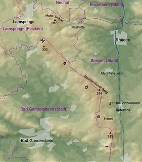
The Heber is a hogback ridge, relatively small in area and up to 313.5 metres high, in the Lower Saxon Hills within the districts of Goslar, Northeim and Hildesheim in the German state of Lower Saxony.

The Harly Forest is a hill range up to 256 m (840 ft) above NN in the district of Goslar in southeastern Lower Saxony, Germany.
The Rotenberg is a hill range, up to 317.3 m high, in the Lower Saxon Hills in southeastern Lower Saxony, Germany.
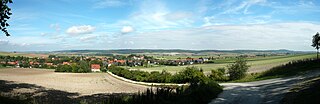
The Ambergau is a historic landscape and natural region unit in the Innerste Uplands in southern Lower Saxony, Germany. It is a basin, about 10 x 10 kilometres across, with 18 settlements, the centre and capital of which since the 13th century is the town of Bockenem. The basin, with its fertile agricultural fields, is surrounded by the wooded ridges of Heber, the Harplage, the Weinberg and the Hainberg. The Gau is a cultural landscape that was formed as early as the 8th century.

At 358.9 m above sea level (NHN) the Griesberg near Bad Salzdetfurth in the Lower Saxon county of Hildesheim is the highest hill in the Hildesheim Forest, a small range of the Innerste Uplands.