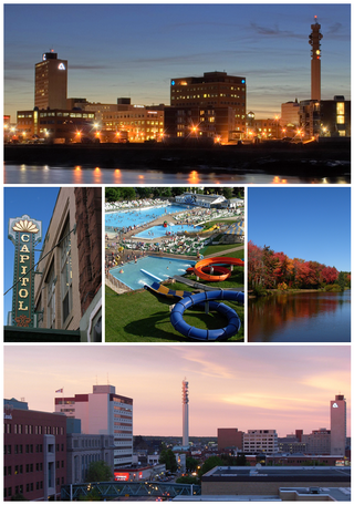
Moncton is the most populous city in the Canadian province of New Brunswick. Situated in the Petitcodiac River Valley, Moncton lies at the geographic centre of the Maritime Provinces. The city has earned the nickname "Hub City" because of its central inland location in the region and its history as a railway and land transportation hub for the Maritimes. As of the 2021 Census, the city had a population of 79,470. The metropolitan population in 2022 was 171,608, making it the fastest growing CMA in Canada for the year with a growth rate of 5.3%. Its land area is 140.67 km2 (54.31 sq mi).

A national park is a natural park in use for conservation purposes, created and protected by national governments. Often it is a reserve of natural, semi-natural, or developed land that a government declares or owns. Although individual countries designate their own national parks differently, there is a common idea: the conservation of 'wild nature' for posterity and as a symbol of national pride. National parks are almost always open to visitors.

Saint John is a seaport city located on the Bay of Fundy in the province of New Brunswick, Canada. It is Canada's oldest incorporated city, established by royal charter on May 18, 1785, during the reign of George III. The port is Canada's third-largest by tonnage with a cargo base that includes dry and liquid bulk, break bulk, containers, and cruise. The city was the most populous in New Brunswick until the 2016 census, when it was overtaken by Moncton. It is currently the second-largest city in the province, with a population of 69,895 over an area of 315.59 km2 (121.85 sq mi).

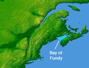
The Bay of Fundy is a bay between the Canadian provinces of New Brunswick and Nova Scotia, with a small portion touching the U.S. state of Maine. It is an arm of the Gulf of Maine. Its tidal range is the highest in the world. The name is probably a corruption of the French word fendu, meaning 'split'.

Fundy National Park is a national park of Canada located on the Bay of Fundy, near the village of Alma, New Brunswick. It was created on April 10, 1946 and officially opened on July 29, 1950. The park showcases a rugged coastline which rises up to the Canadian Highlands, the highest tides in the world and more than 25 waterfalls. The park covers an area of 207 km2 (80 sq mi) along Goose Bay, the northwestern branch of the Bay of Fundy. When one looks across the Bay, one can see the northern Nova Scotia coast.

Shark Bay is a World Heritage Site in the Gascoyne region of Western Australia. The 23,000-square-kilometre (8,900 sq mi) area is located approximately 800 kilometres (500 mi) north of Perth, on the westernmost point of the Australian continent. UNESCO's listing of Shark Bay as a World Heritage Site reads:

Parks Canada, is the agency of the Government of Canada which manages the country's 48 National Parks, three National Marine Conservation Areas, 172 National Historic Sites, one National Urban Park, and one National Landmark. Parks Canada is mandated to "protect and present nationally significant examples of Canada's natural and cultural heritage, and foster public understanding, appreciation, and enjoyment in ways that ensure their ecological and commemorative integrity for present and future generations".

Irving Oil Ltd. is a Canadian privately-owned intergenerational gasoline, oil, and natural gas producing and exporting company, a subsidiary of the parent company Irving Group of Companies,—one of the largest "private conglomerates" in North America. Irving Oil was one established in 1924 by Canadian oil baron and billionaire, Kenneth "K.C." Irving, whose family fortune when he died in 1992 was estimated by Forbes at USD$5 billion. His son, Arthur, became chairman and president of Irving Oil.
Charles Morris Anderson is a landscape architect and fellow of the American Society of Landscape Architects, He is a Principal of the Phoenix-based landscape architecture firm, Charles Anderson Landscape Architecture, which is the continuation of his practice of the Seattle-based firm Charles Anderson Landscape Architecture.

Joggins is a rural community located in western Cumberland County, Nova Scotia, Canada. On July 7, 2008 a 15-km length of the coast constituting the Joggins Fossil Cliffs was officially inscribed on the World Heritage List.

Protected areas of Canada consist of approximately 12.1 percent of the nation's landmass and freshwater are considered conservation areas, including 11.4 percent designated as protected areas. Approximately 13.8 percent of Canada's territorial waters are conserved, including 8.9 percent designated as protected areas. Terrestrial areas conserved have increased by 65 percent in the 21st century, while marine areas conserved have increased by more than 3,800 percent.

Alma is a disincorporated Village in Fundy Albert, New Brunswick, Canada. It resides in the territorial divisions of parish of Alma, Albert County. Alma is centered on the small delta of the Upper Salmon River and Cleveland Brook, where they empty into Salisbury Bay.

New Brunswick is one of Canada's three Maritime provinces. While New Brunswick is one of Canada's Maritime Provinces, it differs from its neighbours both ethnoculturally and physiographically. Both Nova Scotia and Prince Edward Island are either wholly or nearly surrounded by water and the ocean, therefore, tends to define their climate, economy and culture. New Brunswick, on the other hand, although having a significant seacoast, is sheltered from the Atlantic Ocean proper and has a large interior that is removed from oceanic effects. New Brunswick, therefore, tends to be defined by its rivers rather than its seacoast.

A dark-sky preserve (DSP) is an area, usually surrounding a park or observatory, that restricts or reduces light pollution or maintains and protects naturally dark night skies. Different terms have been used to describe these areas as national organizations and governments have worked independently to create programs. DarkSky International (DarkSky) uses "International Dark Sky Reserve" (IDSR) and "International Dark Sky Park" (IDSP) among others when certifying Dark Sky Places.

The Port of Saint John is a port complex that occupies 120 hectares of land along 3,900 m (12,800 ft) of waterfront of the Saint John Harbour at the mouth of the Saint John River in the city of Saint John, New Brunswick, Canada. The Port of Saint John, with facilities on both sides of the river, is noted for its extreme tidal range and river currents. Because of the semi-diurnal tides and the river influence, slack water occurs at approximately half tide and not at high or low water as at most other ports.
Esri Canada is the Canadian provider of enterprise geographic information system (GIS) software from Esri. GIS allows multiple layers of information to be displayed on a single map. A third of its offerings are professional services.

Irving Shipbuilding Inc. is a Canadian shipbuilder and in-service support provider.
The Irving Group of Companies is an informal name given to those companies owned and controlled by the Irving family of New Brunswick—descendants of Canadian industrialist K.C. Irving: his sons James K., Arthur, and Jack (1932–2010), and their respective children.


