Saint John is a seaport city located on the Bay of Fundy in the province of New Brunswick, Canada. It is Canada's oldest incorporated city, established by royal charter on May 18, 1785, during the reign of George III. The port is Canada's third-largest by tonnage with a cargo base that includes dry and liquid bulk, break bulk, containers, and cruise. The city has a strong industrial base, including oil refining and manufacturing, matched with finance and tourism sectors and research institutions such as the New Brunswick Museum and the University of New Brunswick.

Citadel Hill is a hill that is a National Historic Site in Halifax, Nova Scotia, Canada. Four fortifications have been constructed on Citadel Hill since the city was founded by the English in 1749, and were referred to as Fort George—but only the third fort was officially named Fort George. According to General Orders of October 20, 1798, it was named after King George III. The first two and the fourth and current fort, were officially called the Halifax Citadel. The last is a concrete star fort.

Fort William and Mary was a colonial fortification in Britain's worldwide system of defenses, defended by soldiers of the Province of New Hampshire who reported directly to the royal governor. The fort, originally known as "The Castle," was situated on the island of New Castle, New Hampshire, at the mouth of the Piscataqua River estuary. It was renamed Fort William and Mary circa 1692, after the accession of the monarchs William III and Mary II to the British throne. It was captured by Patriot forces, recaptured, and later abandoned by the British in the Revolutionary War. The fort was renamed Fort Constitution in 1808 following rebuilding. The fort was further rebuilt and expanded through 1899 and served actively through World War II.

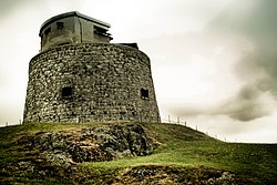
Martello towers, sometimes known simply as Martellos, are small defensive forts that were built across the British Empire during the 19th century, from the time of the French Revolutionary Wars onwards. Most were coastal forts.

Fort Henry National Historic Site is located in Kingston, Ontario, Canada on Point Henry, a strategic, elevated point near the mouth of the Cataraqui River where it flows into the St. Lawrence River at the east end of Lake Ontario. The fort and the point on which the fort was built were named after Henry Hamilton, former Lieutenant-Governor of the Province of Quebec.

Fort York is an early 19th-century military fortification in the Fort York neighbourhood of Toronto, Ontario, Canada. The fort was used to house members of the British and Canadian militaries, and to defend the entrance of the Toronto Harbour. The fort features stone-lined earthwork walls and eight historical buildings within them, including two blockhouses. The fort forms a part of Fort York National Historic Site, a 16.6 ha (41-acre) site that includes the fort, Garrison Common, military cemeteries, and a visitor centre.
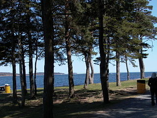
Point Pleasant Park is a large, mainly forested municipal park at the southern tip of the Halifax peninsula. It once hosted several artillery batteries, and still contains the Prince of Wales Tower - the oldest Martello tower in North America (1796). The park is a popular recreational spot for Haligonians, as it hosts forest walks and affords views across the harbour and out toward the Atlantic.

Eastbourne Redoubt is a circular coastal defence fort at Eastbourne, East Sussex, on the south coast of England. It was built in 1805 as part of the British anti-invasion preparations during the Napoleonic Wars. The building is now owned by the local authority and is open to the public.
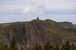
Signal Hill is a hill which overlooks the harbour and city of St. John's, Newfoundland and Labrador, Canada. The majority of Signal Hill, including Cabot Tower, is designated a National Historic Site. The highest point, Ladies' Lookout, is 167 m (548 ft) high.
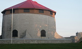
Murney Tower is a Martello tower in Kingston, Ontario, Canada, whose construction dates to January 1846. The Tower was built in response to the Oregon Crisis, which was a tense dispute over the border between British North America and the United States in the 1840s.
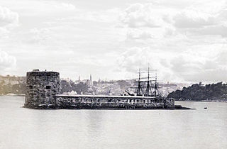
Fort Denison, part of the Sydney Harbour National Park, is a protected national park that is a heritage-listed former penal site and defensive facility occupying a small island located north-east of the Royal Botanic Garden and approximately 1 kilometre (0.62 mi) east of the Opera House in Sydney Harbour, New South Wales, Australia. The island is also known as Mattewanye or Muddawahnyuh in the Eora language, and as Pinchgut Island.

The Battlefields Park includes the Plains of Abraham with the nearby and smaller Des Braves park, both within the district of Montcalm in Quebec City, and forms one of the few Canadian national urban parks. Its significance lies in the Battle of the Plains of Abraham (1759) and the Battle of Sainte-Foy, fought six months later on today's Des Braves park.

York Redoubt is a redoubt situated on a bluff overlooking the entrance to Halifax Harbour at Ferguson's Cove, Nova Scotia, Canada, originally constructed in 1793. It was designated a National Historic Site of Canada in 1962.

The Kingston Royal Naval Dockyard was a Royal Navy Dockyard from 1788 to 1853 in Kingston, Ontario, Canada, at the site of the current Royal Military College of Canada.

Fort Frederick is a historic military building located on Point Frederick on the grounds of the Royal Military College of Canada (RMC) in Kingston, Ontario, Canada. Its construction dates to 1846 and the Oregon boundary dispute. The fort consists of earthworks surrounding a Martello tower. Fort Frederick is included in two separate National Historic Sites of Canada: Kingston Fortifications National Historic Site and the Point Frederick Buildings National Historic Site.

Cathcart Tower is a Martello tower located on Cedar Island in the St. Lawrence River, off the eastern shore of Fort Henry in Kingston, Ontario, Canada. It is one of four such towers built in the 1840s to protect Kingston's harbour and the entrance to the Rideau Canal. The other towers are: Fort Frederick, Shoal Tower, and Murney Tower. Alexander Mackenzie was a foreman on the construction of the Carthcart Tower and later went on to become Canada's second prime minister 1873–1878. It was his work crew whose boat capsized while returning from Cedar Island, drowning 17 men. Hamilton Cove was subsequently renamed Deadman's Bay.

Shoal Tower, originally known as Victoria Tower, is a Martello tower located in the harbour of Kingston, Ontario, Canada, directly opposite Kingston City Hall. It is one of four such towers built in the 1840s to protect Kingston's harbour and the entrance to the Rideau Canal. Cathcart Tower on Cedar Island, Shoal Tower in the Confederation Basin, Fort Frederick on the grounds of the Royal Military College of Canada, and Murney Tower were part of the same strategic improvements. Although 16 Martello towers were built in Canada, only 11 are still standing, four of them in Kingston.

Fort Howe was a British fort built in Saint John, New Brunswick during the American Revolution. It was erected shortly after the American siege in 1777 to protect the city from further American raids. The 18th and 19th century British Army fortification stood at the mouth of the Saint John River where it empties into the Bay of Fundy. A replica blockhouse has been constructed approximately 250 metres to the northeast of the original structure.
Point Frederick is a 41-hectare (101-acre) peninsula in Kingston, Ontario, Canada. The peninsula is located at the south end of the Rideau Canal where Lake Ontario empties into the St. Lawrence River. Point Frederick is bounded by the Cataraqui River to the west, the St. Lawrence River to the south, and Navy Bay to the east. The peninsula is occupied by the Royal Military College of Canada (RMC). Several of the buildings located on Point Frederick and the site of the old naval dockyard are national historic sites. Fort Frederick, at the south end of the peninsula, is a feature of the Kingston Fortifications National Historic Site of Canada.
The Prince of Wales Tower is the oldest martello tower in North America and is located in Point Pleasant Park, Halifax Regional Municipality, Nova Scotia, Canada. It was built in 1796 by Captain James Straton and was used as a redoubt and a powder magazine. Restored, it was designated a National Historic Site of Canada in 1943.