Saint Andrews, New Brunswick

Last updated

Saint Andrews
Town
Historic Downtown, Saint-Andrews-By-The-Sea.jpg
Historic town centre
Nickname: 
Saint Andrews By-the-Sea
Canada New Brunswick location map 2.svg
Red pog.svg
Saint Andrews
Coordinates: 45°04′26″N67°03′08″W / 45.07399°N 67.05209°W / 45.07399; -67.05209
CountryCanada
Province New Brunswick
County Charlotte
Settled1783
Incorporated1903
Named for Saint Andrew's Day
Government
  TypeNew Brunswick Municipality
  MayorBrad Henderson
  Deputy MayorKate Akagi
  CouncillorsKurt Gumushel, Steve Neil, Marc Blanchard, James Hirtle, Lee Heenan
  CAOChris Spear
Area
[1]
  Land8.35 km2 (3.22 sq mi)
Population
 (2021) [1]
  Total2,048
  Density245.3/km2 (635/sq mi)
  Change (2016–21)
Increase2.svg 14.7%
Time zone UTC-4 (Atlantic (AST))
  Summer (DST) UTC-3 (ADT)
Canadian Postal code
E5B
Area code 506
Telephone Exchange529
NTS Map 21G3 St. Stephen
GNBC CodeDAEBC
Website townofstandrews.ca

Saint Andrews is a town in Charlotte County, New Brunswick, Canada. The historic town is a national historic site of Canada, bearing many characteristics of a typical 18th century British colonial settlement, including the original grid layout with its market square, and the classical architecture. [2]

Contents

Although often shortened in non-official sources to St. Andrews, the town's legal name is spelt Saint Andrews, [3] and appears as such on the town's website; [4] St. Andrews by-the-Sea is a brand used for tourism purposes by the local Chamber of Commerce.

On 1 January 2023, Saint Andrews annexed the local service district of Bayside and Chamcook. [5] Revised census information has not yet been released.

History

The site of the town was named Qunnnoskwamk'ook, meaning long gravel bar in the Malecite-Passamaquoddy language. The present name was given by a French missionary who landed at the site on Saint Andrew's Day. [6] At the eastern end the town is a midden, a pile of shells and other refuse that accumulated over 2,000 years due to year-round activity of the Passamaquoddy. Today it is a provincial heritage site. [7]

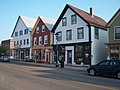
The site was settled in 1783 by Penobscot Loyalists. [8] The town's street grid was designed by Charles Morris and was laid out at that time and persists today. [2] Except for the shoreline Water Street, the names of streets have royal or colonial associations: (Parr Street, Carleton Street and Montague Street are all named after governors. These streets cross thirteen named after the children of King George III.). [9] Also typical of British colonial settlement of the time are the town's defensive sites, public spaces, and delineation. [2]

A blockhouse was built during the War of 1812 and is now a national historic site. St. Andrews Blockhouse - 52014787967.jpg
A blockhouse was built during the War of 1812 and is now a national historic site.

Between 1820 and 1860, the port of Saint Andrews welcomed Irish immigrants. They were first quarantined at Hospital Island, in Passamaquoddy Bay. At the 1851 census, more than 50% of the town's population had been born in Ireland. [11]

The Pendlebury Lighthouse, also known as the St. Andrews North Point Lighthouse, was built in 1833 at the tip of the peninsula. [12] Deactivated in 1938, it has since been restored and registered as a Canadian historic place.

In 1840, the Charlotte County Court House was built, and was used continually until 2016.

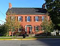
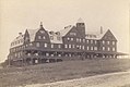
In the late 1800s and early 1900s, St. Andrews became a seaside resort for people from Montreal and Boston who were seeking to escape the summer heat. [9] The town's first seaside hotel, the Argyll, opened in 1881. [13] It was followed in 1889 by The Algonquin, a resort on a hill overlooking the town, which became Canada's first seaside resort. [14] The Argyll burned down in 1892 and was never rebuilt while the Algonquin burned in 1914 and was rebuilt one year later. The lifestyle of wealthy summer visitors is commemorated at the Ross Memorial Museum. [15]

A federal marine research facility, the St. Andrews Biological Station, was established in 1908 [9] and the Huntsman Marine Science Centre in 1969. [16]

The town was designated a national historic site in 1998.

Historical population of Saint Andrews, New Brunswick
Year190119111921193119411951196119811986199119962001200620112016
Population10649871065120711671458153117601612165217521869179818891786

Geography

St. Andrews Harbour at low tide. St. Andrews Harbour at low tide.jpg
St. Andrews Harbour at low tide.

Saint Andrews is at the southern tip of a peninsula, extending into Passamaquoddy Bay. The waterfront faces Saint Andrews Harbour and the Western Channel, which is formed by Navy Island. The harbour is at the mouth of the St. Croix River.

The town is directly opposite the community of Robbinston, Maine, two kilometres to the west across the river mouth, and 53 km by road.

Ministers Island is east of the town and is accessible by road at low tide only. [17]

St. Andrews
Climate chart (explanation)
J
F
M
A
M
J
J
A
S
O
N
D
 
 
109
 
 
−2
−11
 
 
91
 
 
−1
−11
 
 
90
 
 
3
−5
 
 
90
 
 
9
0
 
 
97
 
 
15
5
 
 
84
 
 
20
9
 
 
77
 
 
23
12
 
 
83
 
 
23
12
 
 
97
 
 
19
9
 
 
104
 
 
13
4
 
 
127
 
 
7
0
 
 
121
 
 
0
−8
Average max. and min. temperatures in °C
Precipitation totals in mm
Source: climate-data.org
Imperial conversion
JFMAMJJASOND
 
 
4.3
 
 
28
12
 
 
3.6
 
 
30
12
 
 
3.5
 
 
37
23
 
 
3.5
 
 
48
32
 
 
3.8
 
 
59
41
 
 
3.3
 
 
68
48
 
 
3
 
 
73
54
 
 
3.3
 
 
73
54
 
 
3.8
 
 
66
48
 
 
4.1
 
 
55
39
 
 
5
 
 
45
32
 
 
4.8
 
 
32
18
Average max. and min. temperatures in °F
Precipitation totals in inches

Demographics

In the 2021 Census of Population conducted by Statistics Canada, Saint Andrews had a population of 2,048 living in 921 of its 1,096 total private dwellings, a change of

Transportation

Despite its proximity to the Canada–United States border, the nearest border crossings are 30 km away at St. Stephen or via a ferry service at Deer Island, both in New Brunswick.

The only way into or out of Saint Andrews by land is via Route 127, which runs directly through the town. It meets Route 1 on either end of the town.

Media

A local community channel, CHCO-TV, serves the Saint Andrews and Charlotte County area. The station launched in 1993 on cable television, and began broadcasting over the air in 2006.

Education

See also

Related Research Articles

<span class="mw-page-title-main">Saint John, New Brunswick</span> City in New Brunswick, Canada

Saint John is a seaport city located on the Bay of Fundy in the province of New Brunswick, Canada. It is Canada's oldest incorporated city, established by royal charter on May 18, 1785, during the reign of George III. The port is Canada's third-largest by tonnage with a cargo base that includes dry and liquid bulk, break bulk, containers, and cruise. The city was the most populous in New Brunswick until the 2016 census, when it was overtaken by Moncton. It is currently the second-largest city in the province, with a population of 69,895 over an area of 315.59 km2 (121.85 sq mi).

<span class="mw-page-title-main">Dieppe, New Brunswick</span> City in New Brunswick, Canada

Dieppe is a city in the Canadian maritime province of New Brunswick. Statistics Canada counted the population at 28,114 in 2021, making it the fourth-largest city in the province. On 1 January 2023, Dieppe annexed parts of two neighbouring local service districts; revised census figures have not been released.

<span class="mw-page-title-main">St. Stephen, New Brunswick</span> Town in New Brunswick, Canada

St. Stephen is a Canadian town in Charlotte County, New Brunswick, situated on the east bank of the St. Croix River around the intersection of New Brunswick Route 170 and the southern terminus of New Brunswick Route 3. The St. Croix River marks a section of the Canada–United States border, forming a natural border between Calais, Maine and St. Stephen. U.S. Route 1 parallels the St. Croix river for a few miles, and is accessed from St. Stephen by three cross-border bridges.

<span class="mw-page-title-main">Campobello Island</span> Island in Campobello, New Brunswick, Canada

Campobello Island is the largest and only inhabited island in Campobello, a geographic parish in southwestern New Brunswick, Canada, near the border with Maine, United States. The island's permanent population in 2021 was 949. It is the site of the Roosevelt Campobello International Park, Head Harbour Lighthouse, and of Herring Cove Provincial Park.

Saint Croix Island, long known to locals as Dochet Island, is a small uninhabited island in Maine near the mouth of the Saint Croix River that forms part of the Canada–United States border separating Maine from New Brunswick. The island is in the heart of the traditional lands of the Passamaquoddy people who, according to oral tradition, used it to store food away from the dangers of mainland animals. The island was the site of an early attempt at French colonization by Pierre Dugua, Sieur de Mons in 1604. In 1984 it was designated by the United States Congress as Saint Croix Island International Historic Site. There is no public access to the island, but there is a visitor contact station on the U.S. mainland and a display on the Canadian mainland opposite the island.

New Brunswick Community College (NBCC) is a community college located throughout various locations in New Brunswick, Canada including Moncton, Miramichi, Fredericton, Saint John, St. Andrews, and Woodstock.

<span class="mw-page-title-main">The Algonquin Resort</span> Historic hotel in St. Andrews, New Brunswick, Canada

The Algonquin Resort is a Canadian coastal resort hotel in the Tudor Revival style, located in St. Andrews, New Brunswick. An architectural icon of New Brunswick, the hotel is the most famous symbol of St. Andrews and one of the most photographed buildings in the province.

<span class="mw-page-title-main">St. George, New Brunswick</span> Unincorporated settlement in New Brunswick, Canada

St. George is a community in the Rural Community of Eastern Charlotte, in Charlotte County, New Brunswick, Canada; it was a town until the end of 2022 and is now part of the rural community of Eastern Charlotte. It is located where the Magaguadavic River flows into the Bay of Fundy, between Passamaquoddy Bay and Lake Utopia.

<span class="mw-page-title-main">Magaguadavic River</span>

The Magaguadavic River is a historic Canadian river located in the province of New Brunswick.

<span class="mw-page-title-main">History of New Brunswick</span>

The history of New Brunswick covers the period from the arrival of the Paleo-Indians thousands of years ago to the present day. Prior to European colonization, the lands encompassing present-day New Brunswick were inhabited for millennia by the several First Nations groups, most notably the Maliseet, Mi'kmaq, and the Passamaquoddy.

<span class="mw-page-title-main">Ministers Island</span> Canadian tidal island in New Brunswicks Passamaquoddy Bay near the town of St. Andrews

Ministers Island is an historic Canadian island in New Brunswick's Passamaquoddy Bay near the town of St. Andrews.

<span class="mw-page-title-main">Saint John City Market</span>

The Saint John City Market in Saint John, New Brunswick, is the oldest continuously operated farmer's market in Canada, with a charter dating from 1785. The market is located at 47 Charlotte Street.

Chamcook is an unincorporated area in Charlotte County, New Brunswick, Canada. It lies between the eastern bank of Chamcook Lake and the western edge of Passamaquoddy Bay.

<span class="mw-page-title-main">Gondola Point</span> Place in New Brunswick, Canada

Gondola Point is a former Canadian village and current neighborhood of the town of Quispamsis located in Kings County, New Brunswick. It was amalgamated with the town of Quispamsis in 1998.

<span class="mw-page-title-main">Saint Andrews Parish, New Brunswick</span> Parish in Canada

Saint Andrews Parish is a geographic parish in Charlotte County, New Brunswick, Canada, located east of St. Stephen.

<span class="mw-page-title-main">Saint George Parish, New Brunswick</span> Parish in Canada

Saint George is a geographic parish in Charlotte County, New Brunswick, Canada, located between St. Stephen and Saint John.

<span class="mw-page-title-main">Saint Patrick Parish, New Brunswick</span> Parish in Canada

Saint Patrick is a geographic parish in Charlotte County, New Brunswick, Canada, located west of St. George and Saint Andrews.

<span class="mw-page-title-main">St. Andrews North Point Lighthouse</span> Lighthouse in St. Andrews, New Brunswick, Canada

The St. Andrews North Point Lighthouse is an active lighthouse in St. Andrews, New Brunswick on the southern tip of the peninsula in the Passamaquoddy Bay; it is commonly known as Pendlebury Lighthouse from the name of the family who took care of it.

<span class="mw-page-title-main">Vallée-des-Rivières</span> Town in New Brunswick, Canada

Vallée-des-Rivières is a town in the Canadian province of New Brunswick. It was formed through the 2023 New Brunswick local governance reforms.

References

  1. 1 2 3 "Census Profile of Saint Andrews, Town (TV)". Statistics Canada. 6 December 2022. Retrieved 21 January 2023.
  2. 1 2 3 "St. Andrews Historic District National Historic Site of Canada". www.pc.gc.ca. Government of Canada. Retrieved 6 June 2020.
  3. "New Brunswick Regulation 85-6 under the Municipalities Act (O.C. 85-45)". Government of New Brunswick. Retrieved 26 July 2020.
  4. "Town of Saint Andrews, New Brunswick". Big Bright Sun Communications. Retrieved 26 July 2020.
  5. "Local Governments Establishment Regulation – Local Governance Act". Government of New Brunswick. 12 October 2022. Retrieved 11 January 2023.
  6. "St. Andrews". Provincial Archives of New Brunswick. Retrieved 21 June 2020.
  7. "Pagan Point". www.historicplaces.ca. Retrieved 6 June 2020.
  8. Siebert, Wilbur (1914). "Provincial Archives of New Brunswick". archives.gnb.ca. The Ohio State University. Retrieved 13 July 2020.
  9. 1 2 3 "Our Heritage". St. Andrews by-the-Sea. Archived from the original on 21 June 2020. Retrieved 6 June 2020.
  10. Parks Canada Agency, Government of Canada (1 June 2020). "St. Andrews Blockhouse National Historic Site". www.pc.gc.ca. Retrieved 6 June 2020.
  11. Irish Canadian Cultural Association of New Brunswick Archived 2009-07-26 at the Wayback Machine
  12. "Pendlebury Lighthouse". www.historicplaces.ca. Retrieved 7 June 2020.
  13. David Sullivan, Argyll Hotel, Old New Brunswick, Accessed August 23, 2016
  14. "Heritage, Arts & Culture". Town of Saint Andrews. Retrieved 6 June 2020.
  15. "Ross Memorial Museum" . Retrieved 6 June 2020.
  16. "Huntsman Marine Science Centre". Huntsman Marine Science Centre. Retrieved 6 June 2020.
  17. "The Van Horne Estate on Ministers Island, Crossing Tides & Time, A Unique Canadian Maritime Coastal Experience, St Andrews by the sea, New Brunswick, Canada". ministersisland.net. Retrieved 6 June 2020.
  18. NBCC St. Andrews, Campus of New Brunswick Community College.
  19. Schools in Anglophone South School District