
Saptari, a part of Madhesh Province, is one of the seventy-seven districts of Nepal. Its district headquarter is Rajbiraj. Saptari is an Outer Terai district. This district covers an area of 1,363 km2 (526 sq mi) and has a population (2011) of 639,284 which makes it the 10th most populated district of Nepal. Saptari is renowned for its agricultural output, and is bordered on the east by the massive Sapta Koshi river.
Siraha District, a district in Madhesh Province, is one of the seventy-seven districts of Nepal. It is situated in the Terai belt of Nepal. The district, with Siraha as its district headquarters, covers an area of 1,188 km2 (459 sq mi). It has population of 637,328 according to census of 2011.The District is bordered with Saptari district in the east, Udayapur districting the north, Bihar state of India in the south and Dhanusa district in the west. Majority of the population here is Yadav, Tharus, Sahs(sahukar), Muslims and ethnic minorities with majority population speaking Maithili language and Nepali language.
Bharatpur is a city in southern central Nepal. It is the third most populous city of Nepal after Kathmandu and Pokhara with 369,377 inhabitants in 2021. It is also the second largest metropolitan city in Nepal by area. It is the district headquarter of the Chitwan District.

Ramkot is a village of the Nagarjun Municipality, Bagmati Province, Nepal. The 2011 Nepal census recorded that Ramkot had a population of 6,303 people in 1,427 independent households.
Ratnanagar is a municipality in Chitwan District of Bagmati Province in Nepal. It is the second biggest municipality after Bharatpur Metropolitan City that was formed in 1997 through the merger of the former Village Development Committees Old-Ratnanagar and Panchakanya. It is adjacent to Chitwan National Park, and serves as a gateway to the park. Agricultural products produced from Ratnanagar includes rice, maize, mustard and vegetables. This municipality is also a major place for production of poultry products and animal husbandry. Tourism is another source of income generation for the people in Ratnanagar. People are directly or indirectly dependent in tourism industry. Ratnanagar is also concerned in environment preservation so in order to preserve and protect environment, eco-friendly electric risk-shaw has also been introduced and available in different parts of this municipality. It lies on the bank of East Rapti River.
Dipsung is a village and Village Development Committee in Khotang District in the Sagarmatha Zone of eastern Nepal. At the time of the 1991 Nepal census, it had a population of 950 living in 205 individual households.

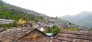
Durlung is a popular village in Kushma Municipality in Parbat District in the Gandaki Province of central Nepal. The formerly Village Development committee was annexed to form the municipality since 18 May 2014. At the time of the 1991 Nepal census it had a population of 3202 people living in 659 individual households. Durlung kot mandir is quite famous historical place. One of the king used to live there when Nepal had distributed in 22/24 state. Most of the people are BRAHMINS followed by Chhetri, Gurung, Magar, Kami and other castes. The main occupation of this village is Agriculture. There is a huge problem of youth migration in this village due to the reason that no higher education colleges and employment opportunities are not available in the village. The village is situated at the altitude of around 1200m to 1500m. We can reach Durlung village by getting a bus to Kushma from any city of Nepal. After reaching Kushma we can get bus from Durlung chowk, Kushma or can hire a jeep or taxi to Durlung. It takes around 30 minutes from Kushma by bus. After reaching Durlung Kot a beautiful temple of 'durlung ka bhume devata' a god of Durlung. Every year during Dashain festival many animals are sacrificed for the god and many people around the district come to visit this historical place. Durlung kot have a view tower and one can enjoy the beautiful sceneries of Machhapuchhre and Annapurna mountain range. The place has huge religious and tourism potential. With the great potentiality of tourism village consists cannoying services on the stream of chanaute. Consisting of both public and private school there is good progress of education. With many of culture of brahmin, Gurung, newar we could find different diversity. The morning of durlunge's start with the fresh air blowing from Machhapuchchhre, annapurna. The life style of people is amazing with different basic facilities. The beauty of durlung cannot be expressed in words, we could only see it by visiting it by ourself. Hope to see you soon.
Ghyang Sukathokar is a village development committee (VDC) in Dolakha District in the Janakpur Zone of north-eastern Nepal. At the time of the 1991 Nepal census it had a population of 4,600.
Betauna is a village development committee in Siraha District in the Sagarmatha Zone of south-eastern Nepal. At the time of the 2011 Nepal census In this Village Mainly And many others People Cast Live in this village ! This Village is developing Village !!
Bhokraha (Hindi:"भोक्राहा") is a Village Development Committee in Siraha District in the Sagarmatha Zone of south-eastern Nepal. At the time of the 2011 Nepal census it had a population of 1757 people residing in 341 individual households.
Kalyanpur Jabadi is a village development committee in Siraha District in the Sagarmatha Zone of south-eastern Nepal. At the time of the 1991 Nepal census it had a population of 9326.Now it become one of the metropolitan cities in Nepal.
Kalyanpur Kalabanjar is a village development committee in Siraha District in the Sagarmatha Zone of south-eastern Nepal. At the time of the 1991 Nepal census it had a population of 3211.
Khirauna is a village development committee in Siraha District in the Sagarmatha Zone of south-eastern Nepal. In 1991, it had a population of 2870 living in 496 individual households. Different casts of people live in the village, including Goit, Mandal, Thakur and Paswan. The main occupation of people in the village is agriculture.
Navarajpur is a “Rural Municipality” (Gaunpalika) previously known as “Village Development Committee (VDC). Rural Municipality is the newly formed lower administrative division in Nepal. The ministry of Federal Affairs and local development dissolved the existing VDC’s and announced the establishment of this new local bodies.
Biranchi Barwa is a village development committee (VDC) in Parsa District in the Narayani Zone of southern Nepal. At the time of the 2011 Nepal census it had a population of 3,625 people living in 558 individual households. There were 1,846 males and 1,779 females at the time of census.

Letang, "लेटाङ " is a municipality in Morang District in the Province No. 1 of south-eastern Nepal. It was formed by merging the existing Village Development Committees of Letang, Jante, Warrangi and Bhogateni. This municipality is situated in Hilly Region as well as Terai Region. Previously it was called Letang Bhogateni but now it's known as Letang.

Kalaigaon is a town and Legislative Assembly Constituency in north-eastern India. It is situated in the Udalguri district of Assam state. The average altitude is 37 meters. The climate is humid and congenial, while the relative humidity is around 82%. The annual rainfall is around 2,000 mm.
Khajuraha is an ancient northern Indian village situated in Saharsa district of Bihar. It is one of the largest panchayats of the state, both by area and population. The origin of the name Khajuraha is unknown. Khajuraha is part of Sonbarsa Raj block of Saharsa district. Some of the neighbouring places include Chandiasthan Gazipaita, Biratpur, Lagma, and Golma. Saint Pritamnath (Babajee) lived in this village.
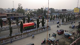
Kalyanpur is a municipality in Siraha District in the Sagarmatha Zone of south-eastern Nepal. At the time of the 2011 Nepal census it had a population of 49288 people living.
Annapurna Rural Municipality, Kaski is a Gaunpalika in Kaski District in Gandaki Province of Nepal named after the Annapurna Mountain. On 12 March 2017, the Government of Nepal implemented a new local administrative structure. With the implementation of the new local administrative structure, VDSs have been replaced with Municipal and Village Councils. Annapurna Gaupalika is one of these 753 local units.

