Siraha District, a district in Madhesh Province, is one of the seventy-seven districts of Nepal. It is situated in the Terai belt of Nepal. The district, with Siraha as its district headquarters, covers an area of 1,188 km2 (459 sq mi). It has population of 637,328 according to census of 2011.The District is bordered with Saptari district in the east, Udayapur districting the north, Bihar state of India in the south and Dhanusa district in the west. Majority of the population here is Kushwaha(Mahato/Singh), Yadav, Tharus, Sahs(sahukar), Muslims and ethnic minorities with majority population speaking Maithili language and Nepali language.
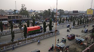
Siraha is the headquarters and municipality of Siraha District, a part of Madhesh Province, Nepal. Siraha had a population of 28,442 according to the census of 2011. and a population of 82,531 as of 2015. The current population of Siraha municipality as of census 2022, is 96,543. It has a male population of 47,306 and female population of 49,237. The present mayor of Siraha Municipality is Dr. Nabin Kumar Yadav and Deputy Mayor is Babita Kumari Sah. Both assumed office on 25 May 2022. His predecessor mayor was Asheswor Yadav and the deputy mayor was Dr. Namita Yadav. Both assumed office on 25 September 2017 and their last working day was on 24 May 2022. The town is at 80 metres (260 ft) altitude, 29 kilometres (18 mi) ESE of Janakpur.
Aurahi is a Rural municipality in Siraha District in Madhesh Province of Nepal. It was formed in 2016 occupying current 5 sections (wards) from previous 5 former VDCs. It occupies an area of 35.87 km2 with a total population of 23,046.
Karjanha is a Municipality in Siraha District in the Madhesh Province of East of Nepal. At the time of the 1991 Nepal census it had a population of 5296 people living in 954 individual households. Also birth place for two most famous people from this Municipality Chef Santosh shah and Upendra mahato
Mohanpur Kamalpur is a village of Sukhipur municipality in Siraha District of Madhesh pradesh of south-eastern Nepal. At the time of the 1991 Nepal census it had a population of 4065 people living in 729 individual households.
Mirchaiya formerly known as Ramnagar Mirchaiya is a municipality in Siraha District in the Madhesh Province of south-eastern Nepal. The municipality was established on 18 May 2014 by merging the existing Rampur Birta, Malhaniyakhori, Radhopur, Ramnagar Mirchaiya, Phulbariya, Sitapur PraDa and Maheshpur Gamharia Village Development Committees. At the time of the 2017 municipality records, it had a population of approx. 52,000 people living in approx 8,496 individual households. This is one of the main business markets for Katari and the southern part of the Siraha district. Raw material produced here includes padday, miazem, and sugar cane.
Sukhipur is a municipality in Siraha District in the Madhesh Province of south-eastern Nepal. After the government announcement the municipality was established on 19 September 2015 by merging the existing Mohanpur Kamalpur, Vidhyanagar, Kushaha Laksiminiya, Kabilasi, Silorba Pachhawari Balhi and Sukhipur village development committees (VDCs). The center of the municipality is established in Sukhipur Bazaar. At the time of the 2011 Nepal census after merging the seven VDCs population it had a total population of 20,915 persons. After the government decision the number of municipalities has reached 217 in Nepal.
Ramaul is a village in Siraha Municipality in Siraha District in the Madhesh Province of south-eastern Nepal. It is surrounded by Makhanaha from the east side, Basbitta from the north-west side, Manpur from the south-west side, Madar from the south-north side and Kamala River from the west side. At the time of the 1991 Nepal census it had a population of 5000 people living in 400 individual households. Before it was under the Village development committee, of Siraha Nepal in 1991 Nepal census. Now it lies under the Siraha Municipality-3,4, and 5. It is divided into five areas (Tolas): Purab Tola, Uttar Tola, Paschim Tola, Dakshin Tola, and Mansoori Tola. It is a Muslim-dominated village with a population of around 20000-25000. The ward commissioner of Siraha Municipality from Ward No 4 is Mohammad SHAMSHAD ALAM. And the ward commissioner of siraha municipality from ward No.5 is JAGESHWAR YADAV .Both of them took office on 30 May 2022. His predecessor ward commissioner of Siraha Municipality from Ward No 4 was Sheikh Haji Izharul Haque .And From ward No.5 was SULINDRA. Both of them took office on 25 September 2017 and their last date of work was on May 29, 2022.
Dhangadhimai Municipality is a municipality in Siraha District in Madhesh Province of eastern Nepal. After the government announcement the municipality was established on 19 September 2015 by merging the existing Bhawanipur, Hanuman Nagar, Phulkaha Kati, Dhangadi and Bishnupurkati village development committees (VDCs). The center of the municipality is established in Dhangadhi Bazaar. At the time of the 2011 Nepal census after merging the four VDCs population it had a total population of 47,449 persons. After the government decision the number of municipalities has reached 217 in Nepal.
Bishnupur is a rural municipality in Siraha District in Province No. 2 of south-eastern Nepal. At the time of the 2011 Nepal census it had a population of 18,522 people living.
Arnama is a rural municipality in Siraha District in Province No. 2 of south-eastern Nepal. At the time of the 2011 Nepal census it had a population of 22,912 people living.
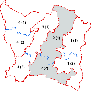
Siraha 2 is one of four parliamentary constituencies of Siraha District in Nepal. This constituency came into existence on the Constituency Delimitation Commission (CDC) report submitted on 31 August 2017.

Siraha 4 is one of four parliamentary constituencies of Siraha District in Nepal. This constituency came into existence on the Constituency Delimitation Commission (CDC) report submitted on 31 August 2017.
Ram Kumar Yadav is a Nepalese politician. He is a member of Provincial Assembly of Madhesh Province from CPN. Yadav, a resident of Golbazar, Siraha, was elected via 2017 Nepalese provincial elections from Siraha 3(A).
Jagat Prasad Yadav is a Nepalese politician. He is a member of Provincial Assembly of Madhesh Province from CPN. Yadav is a resident of Golbazar, Siraha. He is one of great personality of madhesh Pradesh.
Madhesh Province Cricket Association also known as Madhesh Pradesh Cricket is the governing body for cricket in Madhesh Province, a domestic cricket team representing the state of Madhesh, Nepal.

Siddhicharan Highway (NH20) is a National Highway of Nepal located between Madhesh Province and Koshi Province. The total length of the highway is 193 kilometres (120 mi) which passes through Siraha District of Madhesh Province and Udayapur District, Okhaldhunga District, Solukhumbu District of Koshi Province. It starts in Terai region at Madar and crosses NH01 in Mirchaiya Municipality and runs towards north where it passes through Sivalik Hills and enters in Inner Terai valley in Katari Municipality, at there it crosses NH09 then it moves further north climbing Mahabharat Range or Lesser Himalayas where it crosses NH03 (Mid-Hills Highway and enters hilly town Okhaldhunga of Siddhicharan Municipality. It crosses NH75 at Okhaldhunga and runs further North towards Salleri. The distance between Okhaldhunga to Salleri is 57.7 kilometres.

NH80 is a planned National Highway of Nepal which will be constructed Between Madhesh and Koshi orovinces of Nepal. The total length of the highway is planned to be 16.40 kilometres (10.19 mi).

