Siraha District, a district in Madhesh Province, is one of the seventy-seven districts of Nepal. It is situated in the Terai belt of Nepal. The district, with Siraha as its district headquarters, covers an area of 1,188 km2 (459 sq mi). It has population of 637,328 according to census of 2011.The District is bordered with Saptari district in the east, Udayapur districting the north, Bihar state of India in the south and Dhanusa district in the west. Majority of the population here is Kushwaha(Mahato/Singh), Yadav, Tharus, Sahs(sahukar), Muslims and ethnic minorities with majority population speaking Maithili language and Nepali language.
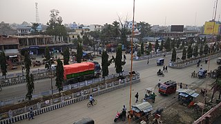
Siraha is the headquarters and municipality of Siraha District, a part of Madhesh Province, Nepal. Siraha had a population of 28,442 according to the census of 2011. and a population of 82,531 as of 2015. The current population of Siraha municipality as of census 2022, is 96,543. It has a male population of 47,306 and female population of 49,237. The present mayor of Siraha Municipality is Dr. Nabin Kumar Yadav and Deputy Mayor is Babita Kumari Sah. Both assumed office on 25 May 2022. His predecessor mayor was Asheswor Yadav and the deputy mayor was Dr. Namita Yadav. Both assumed office on 25 September 2017 and their last working day was on 24 May 2022. The town is at 80 metres (260 ft) altitude, 29 kilometres (18 mi) ESE of Janakpur.
Dhikurpokhari is a suburb and former Village Development Committee in Kaski District in the Gandaki Province of northern-central Nepal. At the 1991 Nepal census, it had a population of 7,392 persons in 1,427 individual households.
Melung is a Rural municipality located within the Dolakha District of the Bagmati Province of Nepal. The municipality spans 86.54 square kilometres (33.41 sq mi) of area, with a total population of 20,210 according to a 2011 Nepal census.
Aurahi is a Rural municipality in Siraha District in Madhesh Province of Nepal. It was formed in 2016 occupying current 5 sections (wards) from previous 5 former VDCs. It occupies an area of 35.87 km2 with a total population of 23,046.
Bariyarpatti is a Rural municipality in Siraha District in Province No. 2 of Nepal. It was formed in 2016 occupying current 5 sections (wards) from previous 5 former VDCs. It occupies an area of 37.72 km2 with a total population of 25,256. Md Gulab Ansari
'Itari prasahi 'which was once a VDC is now a ward no 3 of kalyanpur municipality of siraha district, province no 2, Nepal. It is the heart of the kalyanpur Municipality. It is the most populated ward as well as the largest in area of kalyanpur municipality. Also, It is the richest ward among all 12 ward. Most of the people depend upon agriculture and animal husbandry, fishery for their livelihood. Very few people are business men, teachers, doctors, engineers etc.
Karjanha is a Municipality in Siraha District in the Madhesh Province of East of Nepal. At the time of the 1991 Nepal census it had a population of 5296 people living in 954 individual households. Also birthplace for two most famous people from this Municipality Chef Santosh shah and Upendra mahato
Madar, Nepal is a village development committee in Siraha District in the Sagarmatha Zone of south-eastern Nepal. At the time of the 1991 Nepal census it had a population of 7247 people living in 1203 individual households, with the local Maithali language. Had one health post with minimum facility. Temples are Shree Mata Durga Bhagabati, Shree Mmata Kali, the oldest one shree ramjanki temple. This VDC is situated beside borderline of India.
Naraha Balkawa is a village development committee in Siraha District in the Sagarmatha Zone of south-eastern Nepal. At the time of the 1991 Nepal census it had a population of 3376 people living in 626 individual households.
Mirchaiya formerly known as Ramnagar Mirchaiya is a municipality in Siraha District in the Madhesh Province of south-eastern Nepal. The municipality was established on 18 May 2014 by merging the existing Rampur Birta, Malhaniyakhori, Radhopur, Ramnagar Mirchaiya, Phulbariya, Sitapur PraDa and Maheshpur Gamharia Village Development Committees. At the time of the 2017 municipality records, it had a population of approx. 52,000 people living in approx 8,496 individual households. This is one of the main business markets for Katari and the southern part of the Siraha district. Raw material produced here includes padday, miazem, and sugar cane.
Sakhuwanankar Katti is a village development committee in Siraha District in the Sagarmatha Zone of south-eastern Nepal. At the time of the 1991 Nepal census it had a population of 2594 people living in 419 individual households.
Ramaul is a village in Siraha Municipality in Siraha District in the Madhesh Province of south-eastern Nepal. It is surrounded by Makhanaha from the east side, Basbitta from the north-west side, Manpur from the south-west side, Madar from the south-north side and Kamala River from the west side. At the time of the 1991 Nepal census it had a population of 5000 people living in 400 individual households. Before it was under the Village development committee, of Siraha Nepal in 1991 Nepal census. Now it lies under the Siraha Municipality-3,4, and 5. It is divided into five areas (Tolas): Purab Tola, Uttar Tola, Paschim Tola, Dakshin Tola, and Mansoori Tola. It is a Muslim-dominated village with a population of around 20000-25000. The ward commissioner of Siraha Municipality from Ward No 4 is Mohammad SHAMSHAD ALAM. And the ward commissioner of siraha municipality from ward No.5 is JAGESHWAR YADAV .Both of them took office on 30 May 2022. His predecessor ward commissioner of Siraha Municipality from Ward No 4 was Sheikh Haji Izharul Haque .And From ward No.5 was SULINDRA. Both of them took office on 25 September 2017 and their last date of work was on May 29, 2022.
Golbazar is a municipality in Siraha District in the Madhesh Province of south-eastern Nepal. Golbazar Municipality was formed by merging former VDCs of Asanpur, Jamadaha, Ashokpur Balkawa, Betauna, Durgapur, Lalpur, Muksar, Chandraudyapur, and Chandralalpur under a new local administrative structure implemented by the Government of Nepal. As per the 2011 Nepal census it had a population of 47763 people living in 2500 individual households.
Bhagwanpur is a rural municipality in Siraha District in Province No. 2 of south-eastern Nepal. At the time of the 2011 Nepal census it had a population of 20957 people living. It is located nearly 370 kilometers or 107 miles east of the capital, Kathmandu.
Bishnupur is a rural municipality in Siraha District in Province No. 2 of south-eastern Nepal. At the time of the 2011 Nepal census it had a population of 18,522 people living.
Arnama is a rural municipality in Siraha District in Province No. 2 of south-eastern Nepal. At the time of the 2011 Nepal census it had a population of 22,912 people living.
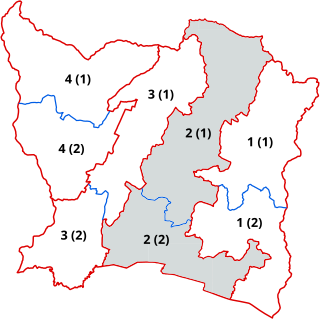
Siraha 2 is one of four parliamentary constituencies of Siraha District in Nepal. This constituency came into existence on the Constituency Delimitation Commission (CDC) report submitted on 31 August 2017.

Siraha 3 is one of four parliamentary constituencies of Siraha District in Nepal. This constituency came into existence on the Constituency Delimitation Commission (CDC) report submitted on 31 August 2017.

Siraha 4 is one of four parliamentary constituencies of Siraha District in Nepal. This constituency came into existence on the Constituency Delimitation Commission (CDC) report submitted on 31 August 2017.

