
DeKalb–Peachtree Airport is a county-owned, public-use airport in DeKalb County, Georgia, United States. The airport is located in the city of Chamblee, just northeast of Atlanta. It is also known commonly as Peachtree–DeKalb Airport, or simply PDK. Other names include Peachtree Airport, DeKalb Airport, or DeKalb County Airport. ASOS weather reports are produced 24 hours per day as "Chamblee". It has airline service with Ultimate Air Shuttle to Cincinnati and Southern Airways Express to Memphis and Destin.

Aspen/Pitkin County Airport, also known as Sardy Field, is a county-owned public-use airport located three nautical miles (6 km) northwest of the central business district of Aspen, in Pitkin County, Colorado, United States. Aspen/Pitkin Co. Airport/Sardy Field covers an area of 573 acres (232 ha) at an elevation of 7,820 feet above mean sea level. It has one asphalt paved runway designated 15/33 which measures 8,006 by 100 feet.
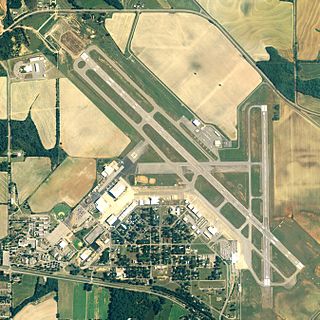
Dothan Regional Airport is a public airport in Dale County, Alabama, United States, seven miles northwest of Dothan, a city mostly in Houston County.

Arnold Palmer Regional Airport is in Westmoreland County, Pennsylvania, United States, two miles (3 km) southwest of Latrobe and about 33 miles (53 km) southeast of Pittsburgh. It was formerly Westmoreland County Airport; it was renamed in September 1999 for Arnold Palmer as part of his 70th birthday celebration. Palmer learned to fly at the airport, and the dedication ceremony included Governor Tom Ridge and a flyover of three A-10s of the Pennsylvania Air National Guard.

Grant County International Airport is a public use airport in the northwest United States, located six miles (10 km) northwest of the central business district of Moses Lake in Grant County, Washington. Formerly a military facility, the airport is owned by the Port of Moses Lake, and its 13,500-foot (4,110 m) runway is the 17th longest in the U.S.

Nome Airport is a state-owned public-use airport located two nautical miles (4 km) west of the central business district of Nome, a city in the Nome Census Area of the U.S. state of Alaska.

Abraham Lincoln Capital Airport is a civil-military airport in Sangamon County, Illinois, United States, three miles (6 km) northwest of downtown Springfield. It is owned by the Springfield Airport Authority (SAA).
Abrams Municipal Airport is a city-owned, public-use airport located two nautical miles (3.7 km) north of the central business district of Grand Ledge, a city in Eaton County, Michigan, United States. It is included in the Federal Aviation Administration (FAA) National Plan of Integrated Airport Systems for 2017–2021, in which it is categorized as a local general aviation facility.
Currituck County Regional Airport is a county-owned, public-use airport in Currituck County, North Carolina, United States. It is located four nautical miles south of the central business district of Currituck, North Carolina. This airport is included in the National Plan of Integrated Airport Systems for 2011–2015, which categorized it as a general aviation facility. It was previously known as Currituck County Airport or Currituck Regional Airport.

Wakulla County Airport is a county-owned, public-use airport in Wakulla County, Florida, United States. It is located three nautical miles (6 km) south of the central business district of Panacea, Florida.

Grove Hill Municipal Airport was a city-owned public-use airport located two nautical miles southeast of the central business district of Grove Hill, a city in Clarke County, Alabama, United States. According to the FAA's National Plan of Integrated Airport Systems for 2009–2013, it was categorized as a general aviation facility. The airport has been permanently closed.
Scammon Bay Airport is a state-owned public-use airport located in Scammon Bay, a city in the Kusilvak Census Area of the U.S. state of Alaska.
Bear Creek 3 Airport is a public-use airport located three nautical miles west of the central business district of Bear Creek, in the Yukon-Koyukuk Census Area of the U.S. state of Alaska. Bear Creek 3 is 40 nautical miles north of McGrath Airport.
Blaine Municipal Airport was a city-owned public-use airport, also known as Dierks Field, located one nautical mile (1.8 km) east of the central business district of Blaine, a city in Whatcom County, Washington, United States. It was closed on December 31, 2008.

Deblois Flight Strip is a public-use airport located two nautical miles southeast of the central business district of Deblois, a town in Washington County, Maine, United States. It is currently owned by the Maine Department of Transportation, and managed by Randy Gray, Superintendent of Operations for the Eastern Region.

Omak Airport, also known as Omak Municipal Airport or Omak City Airport, is a regional airport located 3 miles (4.8 km) north of Omak, Washington, a city in the Okanogan region of United States. It is owned and operated by the Omak City Council and serves Omak, although it is situated in nearby town Riverside's city limits rather. The airport was built by the United States Army Air Forces around 1942 and was approved for public use the following year. After World War II ended, it was closed and turned over for local government use by the War Assets Administration (WAA). Throughout its history, a number of improvements and expansions have occurred with its terminal, runways and taxiways, specifically in June 1979, when improvements made around that month were celebrated with an air show presentation.

Bowers Field is a county-owned, public-use airport in Kittitas County, Washington, United States. It is located two nautical miles (4 km) north of the central business district of Ellensburg, Washington. This airport is included in the National Plan of Integrated Airport Systems for 2011–2015, which categorized it as a general aviation facility.
Ames Field is a private use airport in Levy County, Florida, United States. It is located three nautical miles (6 km) southwest of the central business district of Trenton, a city in Gilchrist County. It is owned by Bill J. Haynes. It used to be a public use airport owned by Alicia Ames Steele.
Davenport Airport, also known as Davenport Municipal Airport, is a city-owned, public-use airport located one nautical mile (2 km) west of the central business district of Davenport, a city in Lincoln County, Washington, United States. It is included in the National Plan of Integrated Airport Systems for 2011–2015, which categorized it as a general aviation facility.
