
The Laurentian Mountains, also known as the Laurentians or Laurentides, are a mountain range in Canada. The range is 1,448 km long and ranges in height from 500 m with peaks over 1,000 m. The Laurentian Mountains extend across Labrador and Quebec within the Laurentian Upland, which contains foothills in northeastern Ontario. The range is located near the rivers of Ottawa, St. Lawrence, and Saguenay. The Laurentian Mountains primarily stretch across multiple regions in Quebec, with geologic formations such as the Jacques-Cartier Massif located within the range.

The Hautes-Gorges-de-la-Rivière-Malbaie National Park is a provincial park in the Charlevoix region of Quebec, Canada. Centring on the Malbaie River Gorge, it is the centrepiece of the UNESCO Charlevoix biosphere reserve. It is administered by the Société des établissements de plein air du Québec (Sépaq). The park can be reached via a local road, 30 kilometers (19 mi) northwards from Route 138 in Saint-Aimé-des-Lacs.

Gaspésie National Park is a provincial park located south of the town of Sainte-Anne-des-Monts, Quebec, Canada in the inland of the Gaspé peninsula. The park contains the highest peak of the Appalachian Mountains in Canada, Mont Jacques-Cartier, 1,270 metres (4,170 ft) above sea level. In addition, the park contains the only population of Caribou found south of the Saint Lawrence River in Canada.

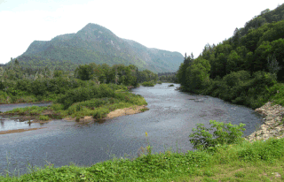
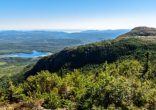
Jacques-Cartier National Park is a provincial park located 50 kilometres (31 mi) north of Quebec City. The park aims to protect wildlife in the Laurentian massif. It lies within the Eastern forest-boreal transition ecoregion.

Réserve faunique des Laurentides, also known by its former name of parc des Laurentides, is a wildlife reserve in Quebec, Canada, located between Quebec City and the Saguenay–Lac-Saint-Jean region. This reserve is part of the network of wildlife reserves of Quebec (Canada) managed by the Ministry of Energy and Natural Resources (Quebec) and the Société des établissements de plein air du Québec. It is located halfway between Saguenay and Quebec.

The Uapishka Biodiversity Reserve is a protected area in the Côte-Nord region of Quebec. It is one of five biodiversity reserves in the province. It is to the east of the Manicouagan Reservoir and includes a large part of the Monts Groulx. It is also part of the central area of the Manicouagan Uapishka Biosphere Reserve.
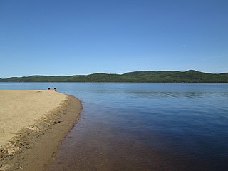
The lac Jacques-Cartier, main source of the Jacques-Cartier River, is a glacial lake located in the Laurentides Wildlife Reserve, about 90 km to the north of the city of Quebec, in the unorganized territory of Lac-Jacques-Cartier, in the La Côte-de-Beaupré Regional County Municipality, in the administrative region of Capitale-Nationale, in the province of Quebec, in Canada.

Lake Sautauriski is a freshwater body crossed from north to south by the Sautauriski River, flowing in the unorganized territory of Lac-Jacques-Cartier, in the La Côte-de-Beaupré Regional County Municipality, in the administrative region of Capitale-Nationale, in province of Quebec, in Canada.
The Rivière à la Chute is a tributary of the Sautauriski River, flowing in the administrative region of Capitale-Nationale, in Quebec, Canada. This watercourse crosses the unorganized territory of Lac-Jacques-Cartier in the MRC La Côte-de-Beaupré Regional County Municipality and the municipality of Stoneham-et-Tewkesbury, in the MRC of La Jacques-Cartier Regional County Municipality.
The Sautauriski mountain culminates at 727 metres (2,385 ft) in the southern part of Jacques-Cartier National Park, in the municipality of Stoneham-et-Tewkesbury, in the regional county municipality (MRC) of La Jacques-Cartier, in the administrative region of Capitale-Nationale, in Quebec, Canada.
The Montagne de l'Épaule peaks at 460 metres (1,510 ft) in Jacques-Cartier National Park, in the municipality of Stoneham-et-Tewkesbury, in La Jacques-Cartier Regional County Municipality, in the administrative region of Capitale-Nationale, in Quebec, Canada.
The Lac des Neiges is a freshwater body located in the unorganized territory of Lac-Jacques-Cartier, in the La Côte-de-Beaupré Regional County Municipality, in the administrative region of Capitale-Nationale, in the province of Quebec, in Canada.
The rivière du Mont Saint-Étienne is a tributary of the Sainte-Anne river, flowing on the north bank of the Saint Lawrence River, in the unorganized territory of Lac-Jacques-Cartier and the municipality of Saint-Ferréol-les-Neiges, in the La Côte-de-Beaupré Regional County Municipality, in the administrative region of Capitale-Nationale, in the province of Quebec, in Canada.
The Petite rivière Savane is a tributary of the Sainte-Anne River, flowing on the north bank of the Saint Lawrence River, in the territory unorganized from Lac-Jacques-Cartier, in the La Côte-de-Beaupré Regional County Municipality, in the administrative region of Capitale-Nationale, in the province of Quebec, in Canada.
The Rivière Brûlé is a tributary of the Sainte-Anne River, flowing on the north bank of the Saint Lawrence River, in the non-territory organized from Lac-Jacques-Cartier, in the La Côte-de-Beaupré Regional County Municipality, in the administrative region of Capitale-Nationale, in the province of Quebec, in Canada.

Mount Xalibu is a mountain located in the unorganized territory of Mont-Albert, in Quebec. Culminating at 1,120 metres (3,670 ft) above sea level, it is one of the highest peaks in the Notre Dame Mountains. It is located in Gaspésie National Park.
The Mont Belle Fontaine, culminating at 1,151 metres (3,776 ft) of altitude, is the highest summit of the Laurentides Wildlife Reserve.
Mont du Lac des Cygnes is a mountain of the Jacques-Cartier Massif, located within the Grands-Jardins National Park in Quebec, Canada. Its summit culminating at 980 metres (3,220 ft) above sea level and overlooking the valley of the Rivière du Gouffre is one of the main attractions of the park.

The mont du Lac à Moïse is a mountain of the Jacques-Cartier Massif located within the Grands-Jardins National Park, in the unorganized territory of Lac-Pikauba, in the Charlevoix Regional County Municipality, in the administrative region of Capitale-Nationale, in Quebec, in Canada. It peaks at 960 metres (3,150 ft).


