Jahanabad, Pilibhit

Last updated


Jahanabad, Pilibhit
Town
Jahanabad (District-Pilibhit)
India Uttar Pradesh location map.svg
Red pog.svg
Jahanabad, Pilibhit
Location in Uttar Pradesh, India
India location map 3.png
Red pog.svg
Jahanabad, Pilibhit
Jahanabad, Pilibhit (India)
Coordinates: 28°38′00″N79°48′00″E / 28.6333°N 79.8000°E / 28.6333; 79.8000 Coordinates: 28°38′00″N79°48′00″E / 28.6333°N 79.8000°E / 28.6333; 79.8000
CountryFlag of India.svg  India
State Uttar Pradesh
District Pilibhit
Elevation
125 m (410 ft)
Population
 (2020)
  Total20,000
Languages
  Official Hindi
Time zone UTC+5:30 (IST)
Vehicle registration UP
Website pilibhit.nic.in

Jahanabad is a town and a nagar panchayat in Pilibhit district in the Indian state of Uttar Pradesh. Community Health Center (CHC) is situated near bazar Jagdeeshpur road. CHC is providing health facilities to community. CHC is under department of medical, health & family welfare . CHC Jahanabad is under block Lalaurikhera .

Green Land - Fertile Land all around Town Jahanabad Green Town Jahanabad.jpg
Green Land - Fertile Land all around Town Jahanabad

Town Jahanabad's major source of earning is agriculture.

Religion wise 98% of the total population is equally held by Hindus & Muslims and rest has been held by other religions like Sikhs, Christians and few more.

60% of the farmers of this town prefer cultivating the sugarcane crop, other 30% prefer the crops of wheat and rice, rest 10% are into other crops. Land is very fertile all around the town.
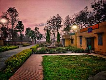
Jahanabad Nagar Panchayat Office Jahanabad Nagar Panchayat Office.jpg
Jahanabad Nagar Panchayat Office

Town Jahanabad is having major three connecting roads,

1. Pilibhit-Bareilly Highway; 2. Pilibhit-Amariya Highway; 3. Jahanabad-Bahedi Highway.

Building was occupied by Priya Video Talkiz in past. Impressive Homes Town Jahanabad.jpg
Building was occupied by Priya Video Talkiz in past.

The oldest market place of this town is known as 'Bazar-Katra' is available at main town road connecting to the town-police-station. Bazar-Katra is having a different variety of shops/stores to fulfill the basic needs of the town, such as Jewellery showroom, Ready-made garments stores, Iron stores, Medical stores, Convenience stores, Grocery store, Sweet Shops, Meat Stores, etc.

This town is having Government managed Hospital & several clinic facilities, schools, Banks, and Post Office.

In earlier days, this town had a well known landmark 'A Cinema Hall' named as 'Priya Video Talkiz'. Which is not working anymore.

Demographics

As of the 2001 Census of India, [1] Jahanabad had a population of 12,420. Males constitute 53% of the population and females 47%. Jahanabad has an average literacy rate of 37%, lower than the national average of 59.5%: male literacy is 46%, and female literacy is 26%. In Jahanabad, 19% of the population is under 6 years of age.

Related Research Articles

<span class="mw-page-title-main">Udhampur</span> City in Jammu and Kashmir, India

Udhampur (ˌʊd̪ʱəmpur) is a city and a municipal council in Udhampur district in the Indian union territory of Jammu and Kashmir. It is the headquarters of Udhampur District. Named after Raja Udham Singh, it serves as the district capital and the Northern Command headquarters of the Indian Army. A Forward Base Support Unit (FBSU) of the Indian Air Force is also stationed here. Udhampur is used by the Armed Forces as a transit point between Jammu and Srinagar when travelling by road on National Highway 1A, which has since then been renamed as National Highway 44.

<span class="mw-page-title-main">Kolaghat</span> Formally Kolaghat, census town of West Bengal, India

Kolaghat is a census town in Kolaghat CD Block, Tamluk subdivision of the Purba Medinipur district in the state of West Bengal, India.

Bhanowara is a census town in the Barabani CD block in the Asansol Sadar subdivision of the Paschim Bardhaman district in the state of West Bengal, India.

Bisalpur is a City and a municipal board situated nearby Pilibhit City in the Pilibhit district of the state of Uttar Pradesh, India. The town is known for its sugar factory as well as its annual Ram Leela and Dushera festival. Bisalpur is in between the two rivers, in West Doha river and in East katna river. Before formation of new District Pilibhit, Bisalpur was under the District Bareilly. In 1913 AD after formation of new District Pilibhit, Bisalpur has come under District Pilibhit Administration. this city is well connected with 03 major cities. Bisalpur is just 290 km away from National capital New Delhi and 250 km from the state capital Lucknow. Bisalpur is famous for Annual Ramleela Fest, Dubey Taalab, Guleshwarnath Temple, Dargah Hazrat Gazi kamaal Degree college and Nagaich Market. Bisalpur is known for many things and places and people of Bisalpur have contributed in various fields one such example is Freedom fight Raees Mohammad who was a freedom fighter and a military man resident of mohalla gayaspur he have won many medals for his extraordinary work he did for the country. he is well known for his charm and Character he played in the public domain now his generation resides in the Bisalpur mohalla gyaspur. Another important place is its railway station which has been modified for the broad gauge. This will help to get well connected with different cities of India.

Debipur is a census town in the Kanksa CD block of the Durgapur subdivision in the Paschim Bardhaman district in the state of West Bengal, India.

Dignala is a census town in the Andal CD block in the Durgapur subdivision of the Paschim Bardhaman district in the state of West Bengal, India.

Gora Bazar is a census town in the community development block of Berhampore, Berhampore subdivision, Murshidabad district, West Bengal, India.

Jaridih Bazar is a census town in the Bermo CD block in the Bermo subdivision of the Bokaro district in the Jharkhand state, India.

<span class="mw-page-title-main">Jaspur</span> Town in Uttarakhand, India

Jaspur is a developing town and a municipal board in Udham Singh Nagar district in the Indian state of Uttarakhand.

Kandra is a census town in the Adityapur CD block in the Seraikela Sadar subdivision of the Saraikela Kharsawan district in the Indian state of Jharkhand.

Kurpania is a census town in the Bermo CD block in the Bermo subdivision of the Bokaro district in the Indian state of Jharkhand.

<span class="mw-page-title-main">Mainaguri</span> Town in West Bengal, India

Mainaguri is a town and a municipality in the Jalpaiguri Sadar subdivision of the Jalpaiguri district in the state of West Bengal, India. It is known as the "Gateway of the Dooars" and is a regionally significant tourist destination for "Jalpesh Temple" of Lord Shiva and nearby Gorumara National Park.

Siduli is a census town in the Andal CD block in the Durgapur subdivision of the Paschim Bardhaman district in the Indian state of West Bengal.

Tekkalakote, also known as Tekkalkota is a Panchayat town, and Pre-historic Neolithic site in Siruguppa taluk of Ballari district in the Indian state of Karnataka.

Haripur is a census town in the Pandabeswar CD block in the Durgapur subdivision of the Paschim Bardhaman district in the Indian state of West Bengal.

Manasa is a town with nagar palika in Neemuch district in the Indian state of Madhya Pradesh. It was under the princely state of Holker before Indian independence.

Rudrapur is a town and a nagar panchayat in Deoria district in the Indian state of Uttar Pradesh.

<span class="mw-page-title-main">Uppala</span> Town in Kerala, India

Uppala is a town and Headquarters of Manjeshwaram Taluk in Kasaragod district, Kerala, India. It is geographically located midway from Kasaragod to Mangalore. Easy geographical access and lack of major towns nearby are the key reasons for the town to develop exponentially, especially in the past decade. The population of Manjeshwaram Taluk alone was over 268,642 as of 2011. Uppala is 22 km north of Kasaragod and one of the fastest growing urban settlements in Kasaragod district. It is well known as an important trade hub in the northernmost part of Kerala state.

Baragaon is a census town in Varanasi district in the state of Uttar Pradesh, India.

Majhola is a town and a nagar panchayat in Pilibhit district in the Indian state of Uttar Pradesh. This town is located 25 km away from district headquarters on state highway 29 connecting Pilibhit to Tanakpur town in Uttaranchal. It is well connected by metre gauge railway line to District headquarters. Geographically, town is located adjacent to Uttaranchal border in terai region. Terai region is famous for its fertile land and industrious farmers. Agriculture is the mainstay of the town economy. It has one sugar factory in cooperative sector, one distillery and few flour mills. Both sugar factory and distillery are now defunct. Demographic profile of town consists of people from different social groups. Dominant among them are farmers which are mainly Sikhs and upper caste group migrants from eastern Uttar Pradesh. Others are business class upper caste people from western Uttar Pradesh who dominates the town economy. The town has two intermediate colleges and one convent school. There are many places of worship belonging to different religions. The place had a very vibrant sport culture which slowly diminished due to exodus of youth out of town for employment.

References

  1. "Census of India 2001: Data from the 2001 Census, including cities, villages and towns (Provisional)". Census Commission of India. Archived from the original on 16 June 2004. Retrieved 1 November 2008.
Small Level Milking.jpg
Farming Jahanabd.jpg