Gumla block is a CD block that forms an administrative division in the Gumla subdivision of Gumla district, in the Indian state of Jharkhand.
Ausgram I is a community development block that forms an administrative division in Bardhaman Sadar North subdivision of Purba Bardhaman district in the Indian state of West Bengal.
Hura is a community development block that forms an administrative division in the Purulia Sadar subdivision of the Purulia district in the Indian state of West Bengal.
Engandiyur is a village in the Chavakkad taluka of the Thrissur district in the state of Kerala, India. It has an area of 1411 hectares and harbours 5,760 households with total population of 23,101 as per the 2011 Census. The nearest town Chavakkad is at a distance of 8 km. Male population is 10,528 and female population is 12,573. Scheduled Caste Population is 615 and Scheduled Tribes population is 45. Census Location Code of the village is 627789.
Kharki is a village of Himachal Pradesh, under Tehsil Kotkhai, Shimla district, India.
Haler is a small village near Tehsil Jaisinghpur. It has an average elevation of 558 metres (1,831 feet). Haler is a village of Himachal Pradesh, under Tehshil Jaisinghpur, Kangra district, India. It is located between Dalu village and Thanpal village. It is situated on the Bank of River Beas. A famous Nag Naguli temple is 4 km from haler, due to this, many pilgrim arrive there. And here is also a Sita ram temple that is situated in the shore of Haler Khad. In Haler there is govt school that provides education up to 10th class.
Dhani is a village located in the Bali tehsil in the Pali district of Rajasthan. It is located near Bali town on state highway SH 62 between Khudala and Khimel in a valley on the western side of the Aravalli Range. Dhani is easily accessed by Western Railway Ahmedabad Delhi route near from Falna and Rani Station. Dhani is famous village in Marwar for Making of Mojari-Shoes. The first lady sarpanch in this village is Nalini kanwar wife of ranveer Singh bhati she was very active in all village activities she make a village very much well as compared to other village.
Darjeeling Pulbazar is a community development block that forms an administrative division in the Darjeeling Sadar subdivision of the Darjeeling district in the Indian state of West Bengal.
Afazalpur Dhobghati Saidpur Village is a village in Bihar, India.
LakhnichakAulai is a village in Vaishali district, Bihar, India.
Ajaysar is a village in Ajmer tehsil of Ajmer district of Rajasthan state in India. It is situated in the rural region of Ajmer division at an elevation of 466 meters above sea level.

Ashrafpur is a village in Chhatoh block of Rae Bareli district, Uttar Pradesh, India. It is located 5 km from Jais, the nearest town. As of 2011, Ashrafpur has a population of 4,918 people, in 807 households. It has one primary school and no healthcare facilities. Ashrafpur is the headquarters of a nyaya panchayat that also includes 5 other villages.
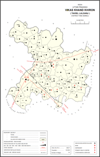
Ketanpur is a village in Khiron block of Rae Bareli district, Uttar Pradesh, India. It is located 14 km from Lalganj, the tehsil headquarters. As of 2011, it has a population of 345 people, in 66 households. It has 1 primary school and no healthcare facilities and does not host a weekly haat or a permanent market. It belongs to the nyaya panchayat of Deogaon.

Tikran is a village in Dalmau block of Rae Bareli district, Uttar Pradesh, India. It is located 8 km from Lalganj, the nearest large town. As of 2011, it has a population of 1,011 people, in 181 households. It has one primary school and no healthcare facilities and does not host a permanent market or weekly haat. It belongs to the nyaya panchayat of Madhukarpur.
Dakauli is a village in Dalmau block of Rae Bareli district, Uttar Pradesh, India. It is located 5 km from Lalganj, the nearest large town. As of 2011, it has a population of 665 people, in 130 households. It has one primary school and no healthcare facilities and does not host a permanent market or weekly haat. It belongs to the nyaya panchayat of Aihar.

Bhakarwara is a village in Rahi block of Rae Bareli district, Uttar Pradesh, India. It is located 12 km from Rae Bareli, the district headquarters. As of 2011, it has a total population of 876 people, in 168 households. It has no schools and no medical facilities and it does not host a weekly haat or a permanent market. It belongs to the nyaya panchayat of Bhadokhar.
Chak Lodipur is a village in Rahi block of Rae Bareli district, Uttar Pradesh, India. It is located 8 km from Rae Bareli, the district headquarters. As of 2011, it has a total population of 449 people, in 89 households. It has one primary school and no medical facilities and it does not host a weekly haat or a permanent market. It belongs to the nyaya panchayat of Rustampur.

Daulatpur is a village in Kadipur block of Kadipur tehsil in Sultanpur district, Uttar Pradesh, India. As of 2011, it has a population of 1,261 people, in 172 households. It has one primary school and no healthcare facilities and it does not host a regular market or a weekly haat. It belongs to the nyaya panchayat of Kalikapur Kalan.
Katawar is a village in the Hadoti region of Rajasthan, India. It serves as a Gram panchayat for six nearby villages which are Manyagan, Achrawa, Bhojukheri, Mehla, Baldevpura. Bichhalas. The nearest town is Atru, which is 22 km away. It is located 52 km from the district headquarter, Baran.

