Sadiqabad is a city and capital of Sadiqabad Tehsil in Rahim Yar Khan District, Punjab province of Pakistan. It is situated at the border of Sindh and Punjab. According to the 2017 Census of Pakistan, it is the 32nd largest city of Pakistan with a population of 238,313.

Rahim Yar Khan is a city in the Punjab province of Pakistan. It is the 9th largest city of Pakistan by population. It is the capital of the Rahim Yar Khan District and Rahim Yar Khan Tehsil. The administration of the city is subdivided into nine Union Councils.

Bahawalnagar, is the capital city of Bahawalnagar District in the Punjab province of Pakistan. The city of Bahawalnagar is the headquarter of the district and tehsil as well. It is the 54th largest city of Pakistan by population according to the 2017 census.. Old name of Bahawalnagar was Rojanwali/Ubbha. It was named Bahawalnagar in 1904 after Bahawal Khan V, the ruler of the Bahawalpur state comprising the present districts of Bahawalpur, Bahawalnagar and Rahim Yar Khan. It is 262 km (163 mi) south of Lahore and about 175 km (109 mi) miles east of Bahwalpur. It is 65 km (40 mi) far from District Pakpattan. River Sutlej passes on the northern side at a distance of about 6 miles.
Rahim Yar Khan District is a district in the province of Punjab, Pakistan. Its headquarters is the city of Rahim Yar Khan.
Khanpur is a city and capital of Khanpur Tehsil of the Rahim Yar Khan District, Bahawalpur Division, in the Punjab province of Pakistan. It is the 45th-largest city of Pakistan by population, according to the 2017 census.
Adam Sahaba is a town and union council of Sadiqabad Tehsil in the Rahim Yar Khan District of Pakistan. It is located at 28°21'50N 70°11'40E and lies between Sadiqabad and Rahim Yar Khan – the tehsil and district capitals respectively. Noteworthy locations in the area include Shrine of Adam Sahaba, with one of the largest graveyards in the Rahim Yaar Kahn district. Saraiki language speakers form an ethnic majority, and the Culture of Sindh is predominant.
Kharian Tehsil is a tehsil located in Gujrat District, Punjab, Pakistan. The land lies between the rivers of Chenab and Jhelum and in the North the foothills of the mountains of Pir Panjal.
Sadiqabad is a tehsil located in Rahim Yar Khan District, Punjab province of Pakistan situated at the border of Sindh and Punjab. It is located on the east bank of the Indus River.
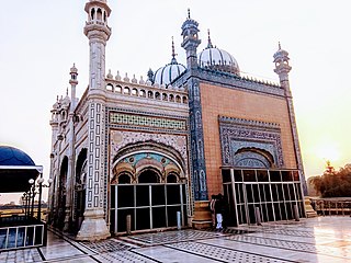
Bhong is a small town of Rahim Yar Khan District in the Punjab province of Pakistan. It is a Union Council of Sadiqabad tehsil and is located 200 kilometres away from Bhawalpur at 28° 25' 0" North, 69° 55' 0" East.
Chachran Sharif, is a town in Khanpur Tehsil of the Rahim Yar Khan District, in the Punjab province of Pakistan.
Rahim Yar Khan Tehsil is an administrative subdivision (tehsil) of Rahim Yar Khan District in the Punjab province of Pakistan.
Khanpur Tehsil may refer to the tehsils headquartered in any of the following towns or cities:
Zahir Pir is a city in the Khanpur Tehsil, Rahim Yar Khan District of Punjab, Pakistan. It is located on N-5 Highway. It has Motorway Exchange from M-5 also. Zahir Pir is connected with Rahim Yar Khan District HQ Khanpur Tehsil HQ (25 km), Chachran Sharif on Indus River Bank (11 km) and connected to Kot Mitthan via a bridge.

The 2012 Rahim Yar Khan bombing occurred on 15 January 2012, when a remote-controlled bomb exploded during a Shi'a Muslim procession in the city of Rahim Yar Khan in the southern region of Punjab province, Pakistan. Eighteen people were killed and dozens other injured, some critically, as a result of the attack.
Khanpur Railway Station is located in Khanpur city, Rahim Yar Khan district of Punjab province of the Pakistan. It is a major railway station of Pakistan Railways on Karachi-Peshawar main line.
Sahja Railway Station is located in Sahja, union council of Tehsil Khanpur Rahim Yar Khan district of the Punjab province, Pakistan.
Muzaffargarh Tehsil, is a tehsil of Muzaffargarh District that falls in DG Khan Division, in the Punjab province of Pakistan.

