
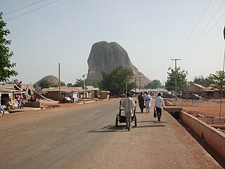
Katsina is a Local Government Area and the capital city of Katsina State, in northern Nigeria.

Kano is one of the 36 states of Nigeria, located in the northern region of the country. According to the national census done in 2006, Kano State is the most populous state in Nigeria. The recent official estimates taken in 2016 by the National Bureau of Statistics found that Kano State was still the largest state by population in Nigeria. Created in 1967 out of the former Northern Region, Kano State borders on Katsina State to the northwest for about 210 km, Jigawa State to the northeast for 355 km, Bauchi State to the southeast for 131 km, and Kaduna State to the southwest for 255 km. The state's capital and largest city is the city of Kano, the second most populous city in Nigeria after Lagos. The incumbent governor of the state is Abba Kabir Yusuf. He was sworn in on 29 May 2023.

Bauchi is a city in northeast Nigeria, the Administrative center of Bauchi State, of the Bauchi Local Government Area within that State, and of the traditional Bauchi Emirate. It is located on the northern edge of the Jos Plateau, at an elevation of 616 m. The Local Government Area covers an area of 3,687 km2 and had a population of 493,810 in 2006.

Bauchi is a state in the North-East geopolitical zone of Nigeria. It is bordered by Jigawa to the north, Yobe to the northeast, Gombe to the east, Taraba and Plateau to the south, Kaduna to the west and Kano to the northwest. It takes its name from the historic city of Bauchi, which also serves as its capital. The state was formed in 1976 when the former North-Eastern State was broken up. It originally included the area that is now Gombe State, which became a distinct state in 1996.

Jigawa is a state in Nigeria, located in the northern region of the country. Jigawa was created on 27 August 1991, under the General Ibrahim Babangida military administration. Jigawa State was formerly part of Kano State and was located in the northeastern-most region of Kano State. It forms part of Nigeria's national border with the Republic of Niger. The state capital and largest city is Dutse. Jigawa state has 27 local governments.
Haɗejiya is a Hausa town in eastern Jigawa State, northern Nigeria. Hadejia lies between latitude 12.4506N and longitude 10.0404E. It shares boundary with Kiri Kasama Local Government to the east, Mallam Maɗori Local Government from to the north, and Auyo Local Government to the west. The Hadejia Local Government consist of eleven (11) political wards, namely: Atafi, Dubantu, Gagulmari, Kasuwar Ƙofa, Kasuwar Kuda, Matsaro, Majema, Rumfa, Sabon Garu, Ƴankoli and Yayari. Inhabitants are dominantly Hausa, Fulani and Kanuri with some other groups such as Tiv, Yoruba, Igbo, Igala etc. The dominant occupation of the inhabitants is crop-farming and animal rearing which a considerable percentage, engaged in trading, fishing and services including civil service. The people of Haɗeja are largely Muslims, although some follow indigenous belief systems. The town lies to the north of the Hadejia River, and is upstream from the Hadejia-Nguru wetlands. Hadejia is an internationally important ecological and sensitive zone.

Ningi is a town, a local government area, and an emirate in Bauchi State, Nigeria. The Ningi emirate comprises two local government areas, Ningi and Warji, with a combined area of 5,250 km2 and a population of 501,912 according to the 2006 Census. The Ningi local government area covers an area of 4,625 km2 with a population of 387,192 at the 2006 Census. The area is inhabited mostly by Hausa people, Duwa, Ningawa. Yunusa Muhammadu Danyaya was the longest Emir to reign who ascended the throne from 1978 until his death on 25 August 2024.

Katagum is a town, a local government area and a traditional emirate in Bauchi State of north eastern Nigeria. The town is located on the northern bank of the Jama'are River, which is a tributary of the Hadejia. Most of the inhabitants are peoples from the Fulani, Kanuri, Karai-karai and Hausa tribes. The chief agricultural products include peanuts (groundnuts), sorghum, millet, rice, cowpeas, cotton, indigo, and gum arabic. Livestock include horses, cattle, goats, sheep, donkeys and a lot of poultry.

Lafia is a city in Nigeria's North Central region. It is the capital and largest city of Nasarawa State, with a population of 509,300 inhabitants as of the 2021 census. And it's the Headquarter of Lafia Emirate Council.
Suleja is a city in Niger State, Nigeria, just north of Abuja, capital of the Nigeria. It is sometimes confused with the nearby city of Abuja, due to its proximity, and the fact that it was originally called Abuja before the Nigerian government adopted the name from the then Emir Sulayman Bal for its new federal capital in 1976.
Wase is a town and Local Government Area (LGA) of Plateau State, Nigeria, situated some 216 km south east of Jos, the Plateau State capital. It shares its name with the nearby Wase River. The population of the LGA was 159,861 people as of 2006, with an urban area of 1750 km².
Daura is a town and local government area in Katsina State, northern Nigeria. It is the spiritual home of the Hausa people. The emirate is referred to as one of the "seven true Hausa states" because it was(along with Biram, Kano, Katsina, Zazzau, Gobir, and Rano), ruled by the descendants of Bayajidda's sons with Daurama and Magira . The University of California's African American Studies Department refers to Daura, as well as Katsina, as having been "ancient seats of Islamic culture and learning."

Azare is a town in Bauchi State, Nigeria. It was founded by Mallam Zaki, who was put into office by Shehu Usman Danfodio in early 1814. Azare is the headquarters of the Katagum division in Bauchi State. It is bordered to the east by Damban LGA and Potiskum Yobe State, to the south by Misau Local Government, to the west by Jama'are Local Government, and to the north by Itas/Gadau Local Government Area of Bauchi State.
Dukku is a Local Government Area in Gombe State, Nigeria. Its headquarters is located in Dukku town. The Gongola River flows through the west and north of the LGA. It has an area of 3,815 km2 and a population of 207,190 from the 2006 census. The vast majority of the population are Muslims, but there is a Christian minority. The major ethnic group is Fulani with Fulfulde being spoken as a major language alongside Bole while Hausa, Kanuri, and Kare-Kare are also spoken.
Kazaure is an Emirate and a Local Government Area of Jigawa State, Nigeria. Its headquarters is in the ancient city of Kazaure.

Bichi is a Local Government Area and a headquarter of Bichi Emirate council in Kano State, Nigeria. Its headquarters are in the town of Bichi on the A9 highway. Bichi was founded by danejawa the white herders under the leadership of Ardo buba the grandfather of Malam danzabuwa
Rano is a Local Government Area and headquarters of Rano Emirate council in Kano State, Nigeria. Rano is a local government area in Kano State with administrative headquarters in the town of Rano. Rano local government area is a Hausa-Fulani community in the southern senatorial district of Kano State otherwise known as Kano South Senatorial District alongside Albasu, Bebeji, Bunkure, Doguwa, Gaya, Kiru, Takai, Ajingi, Rogo, Kibiya, Tudun Wada, Garko, Wudil and Sumaila local government areas. Rano local government area also forms a federal constituency alongside Bunkure and Kibiya local government areas. It has an area of 520 km2 and a population of 145,439 at the 2006 census. The local government area is bounded to the north by Garun Mallam and Bunkure local government areas, to the east by Kibiya local government area, to the south by Tudun Wada local government area, and to the west by Bebeji local government area. The Rano local government council is in charge of public administration in Rano local government area. The council is led by a chairman who is the executive head of the local government. The Rano legislative council make laws governing Rano local government area. It consists of 10 Councillors representing the 10 wards of the local government area.
Lere is a Local Government Area and town in the southern part of Kaduna State, Nigeria. Lere town is located geographically at the latitude of 10 degrees 39 North and longitude of 8 degrees 57 East. It is the headquarters of the Lere Emirate. The town and its environs have an estimated population of about 553,290 (2016). Lere Local Government has an area of 2,634 km2 and a population of 339,740 at the 2006 census. Its headquarters are in the town of Saminaka. The postal code of the area is 811.

The Bauchi Emirate was founded by Yaqubu dan Dadi in the early 19th century in what is now Bauchi State, Nigeria, with its capital in Bauchi. The emirate came under British "protection" in the colonial era, and is now denoted a traditional state.

The Dambazawa are a Fulani clan residing mainly in Kano State, Nigeria. They were among the key promoters, planners and executors of the Fulani Jihad in Kano, which took place between 1804 and 1807 under the leadership of Shehu Usuman dan Fodiyo. The clan was said to be the top financier of the jihad because it was said to be extremely wealthy at the time of the jihad. Other Fulani Clans that participated in the Jihad included: the Jobawa, the Yolawa, the Sullubawa, the Danejawa and others, as well as a contingent of the native Hausa people led by Malam Usuman bahaushe. Together they formed a formidable force and toppled the 158 year Kutumbawa dynasty led by its last ruler Muhammad Alwali dan Yaji dan Dadi bakutumbe who ruled between 1781 and 1806.


