
The Pulwama district is a district in the Indian Union territory of Jammu and Kashmir. Its capital city is Pulwama.

Charar-i-Sharief is a town and a notified area committee in Budgam district in the Indian administered union territory of Jammu and Kashmir, India.

Budgam district is a district in the Indian administered union territory of Jammu and Kashmir. Created in 1979 with its headquarters at Budgam, it is the district with the largest population of Shias in the Kashmir valley.
Chadoora is a town and a Municipal committee in Budgam district in Indian administered union territory of Jammu and Kashmir. Famous sofi and aa'lim Mir Shams-ud-Din Araqi is buried here.
Pattan is a sub-district, town and a municipal committee in Baramulla district in the Indian administered union territory of Jammu and Kashmir.
Iskander Pora is a village in the district Budgam, tehsil Beerwah in the Indian administered union territory of Jammu and Kashmir. It is located about 29 km (18 mi) towards West from district headquarters, Budgam and about 34 km (21 mi) towards West from unoin territory capital Srinagar.
Aripanthan is a village and panchayat halqa in Beerwah tehsil of Budgam district in the Indian union territory of Jammu and Kashmir. Aripanthan is situated at the centre of tehsil Beerwah and tehsil Magam. It is located about 27 km (17 mi) west from summer capital of Jammu and Kashmir, Srinagar and about 28 km (17 mi) north from district headquarters in Budgam.
Badran is a village located in district Budgam in the Indian administered union territory of Jammu and Kashmir.
Dadina or Dadun is a village of Budgam district situated in Budgam block in Jammu and Kashmir, India. It is only 4 km (2.5 mi) from the district headquarters. It is the most neighbouring vicinity to Budgam.
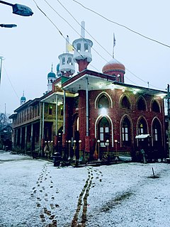
Budgam, known as Badgom in Kashmiri, is a town in Budgam district in the union territory of Jammu and Kashmir, India. In the 2001 census it was recorded as having a notified area committee, but by the 2011 census it had a municipal committee.
Khan Sahib is a town (city) and a notified area committee in Budgam district in the central Kashmir, union territory of Jammu and Kashmir, India. This town is the most developed town in kashmir valley. The area is mostly covered by karewas. The area comprises more than 92 villages.
Ichgam, also known as Ichgram or Ichigam, is a census town located in the Indian administered union territory of Jammu and Kashmir's Budgam district. It falls under the administrative division of tehsil Budgam, one of the nine tehsils of district Budgam. It is one of the most populated area of Budgam district. It is roughly 5 km (3.1 mi) away from district Budgam and nearly 19 km (12 mi) away from Srinagar, the summer capital of union territory of Jammu and Kashmir. Ichgam village consists of four blocks — Ichgam-A, Ichgam-B, Ichgam-C and Ichgam-D. The village consists of both major sects of Islam, Shias and Sunnis. There is also a Hindu minority.
Bagati Kani Pora or B.K. Pora is a village and municipality in Budgam district of the Indian union territory of Jammu and Kashmir.
Soibugh is a town in Budgam district in the Indian-administered union territory of Jammu and Kashmir. It is 8.5 km (5.3 mi) from the summer capital of Jammu and Kashmir, Srinagar. It is one of the highly populated area of district Budgam. Soibugh is one of the 17 blocks of Budgam district.
Dooniwari or Dooniwara is a village in Budgam district of Indian union territory of Jammu and Kashmir, situated 8 km (5.0 mi) away from Srinagar city and 18 km (11 mi) away from Budgam town. The total geographical area of village is 168 ha. Dooniwari has a total population of 1,839 citizens. There are about 278 houses in Dooniwari village as per 2011 census. Areas in its locality include Wathoora, Gopalpora, Chattergam, Kralapora and Bagati Kani Pora.
Guda Sathu is a village in the Budgam district in the Indian Union Territory of Jammu and Kashmir.
Ich Kot or Ichkoot is a village in the Budgam district in the Indian-administered union territory of Jammu and Kashmir.
Choon is a village in the Budgam district in the Indian-administered union territory of Jammu and Kashmir.
Zoonipora is a medium size village in the locality of Dooniwari, located in Chadoora Tehsil of Budgam district, Jammu and Kashmir with total 57 families residing. The Zooni Pora village has population of 471 of which 237 are males while 234 are females as per Population Census 2011.

Arizal is a village in Budgam district in Indian Jammu and Kashmir. It is situated at the base of the Pir Panjal Range of the Himalayas, in the Sukhnag Valley. It falls under the administrative division of tehsil Khansahib, which is one of the nine tehsils of district Budgam. It lies at a distance of about 35 kilometres (22 mi) from the district headquarters Budgam, 16 kilometres (9.9 mi) from the sub-district headquarters Khansahib, and 45 kilometres (28 mi) away from Srinagar, the summer capital of Jammu and Kashmir.

