This bay is mainly included in the township of Leblanc and Aubin. Following the erection completed in 1948 of the Gouin Dam, the "Jean-Pierre Bay" was formed by the raising of the waters of the Jean-Pierre River (Gouin Reservoir). Since 1948, Jean-Pierre Bay has been an extension of the Brochu Lake further north-west, at the extreme east of the Gouin Reservoir.
Recreotourism activities are the main economic activity of the sector. Forestry comes second. A civilian seaplane base is located at the top of the Gouin Dam.
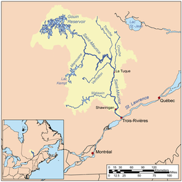
The route 400, connecting the Gouin Dam to the village of Parent, Quebec, serves the southern part of Jean-Pierre Bay, as well as the river valleys Jean-Pierre and Leblanc; this road also serves the peninsula which stretches north in the Gouin Reservoir on 30.1 kilometres (18.7mi). Some secondary forest roads are in use nearby for forestry and recreational tourism activities.
The surface of Jean-Pierre Bay is usually frozen from mid-November to the end of April, however, safe ice circulation is generally from early December to the end of March.
Geography
This bay has a length of 13.9 kilometres (8.6mi) in the North-South direction, resembling a long carrot pointing south. It collects on the east side the waters of the Jean-Pierre River (Gouin Reservoir). This bay is bordered on the west side by a series of mountains.
Jean-Pierre Bay is formed by the Gouin dam. The confluence between Kikendatch Bay and Jean-Pierre Bay is located at:
68.5 kilometres (42.6mi) south-east of the village center of Obedjiwan which is located on a peninsula on the north shore of the Gouin Reservoir;
52.5 kilometres (32.6mi) northwest of the village center of Wemotaci (north shore of the Saint-Maurice River);
143.8 kilometres (89.4mi) north-west of downtown La Tuque;
The current coming from the north-west, from Brochu Lake, joins the northern part of Jean-Pierre Bay. While the current from the Jean-Pierre River (Gouin Reservoir) crosses North Bay Jean-Pierre on 7.5 kilometres (4.7mi) to the entrance of Kikendatch Bay. From there, the current flows eastward on 12.0 kilometres (7.5mi) to the Gouin Dam. From this dam, the current flows along the Saint-Maurice River to Trois-Rivières.
The Wapous River is a tributary of the Gouin Reservoir, flowing in the territory of the town of La Tuque, in the administrative region of Mauricie, in Quebec, in Canada.
The Atimokateiw River is a tributary of the south shore of the Gouin Reservoir, flowing into the territory of the town of La Tuque, in the area of Mauricie, Quebec, Canada.
The Jean-Pierre River is a tributary of the Jean-Pierre Bay, on the south shore of the Gouin Reservoir, flowing into the territory of the town of La Tuque, into the administrative region of Mauricie, in Quebec, in Canada.
The Leblanc River is a tributary of the De La Galette River, flowing on the south shore of the Gouin Reservoir, in the territory of the town of La Tuque, in the Mauricie administrative region, in Quebec, in Canada.
The Lac de la Galette is a freshwater body of the town of La Tuque, in Haute-Mauricie, forming a bay on the south shore of Gouin Reservoir and west of the upper Saint-Maurice River, in the administrative region of Mauricie, in the province of Quebec, in Canada.
The De La Galette River is a tributary of the southern shore of Gouin Reservoir, flowing into the territory of the town of La Tuque, in the administrative region of the Mauricie, in Quebec, in Canada.
The Kikendatch Bay is a freshwater body that leads to the Gouin Reservoir, in the territory of La Tuque, in Haute-Mauricie, in the administrative region of Mauricie, in the province of Quebec, in Canada.
The Lake Brochu is a vast expanse of freshwater in the south-eastern part of the Gouin Reservoir, in the territory of the town of La Tuque, in the administrative region of Mauricie, in the province of Quebec, in Canada.
The Bouzanquet Bay is a vast freshwater body of the south-eastern part of the Gouin Reservoir, in the territory of the town of La Tuque, in Haute-Mauricie, in the administrative region of Mauricie, in the province of Quebec, in Canada.
The Chapman Lake is a vast expanse of freshwater in the central part of the Gouin Reservoir, in the territory of the town of La Tuque, in Haute-Mauricie, in the administrative region of Mauricie, in the province of Quebec, in Canada.
The Lac Bureau is a vast freshwater body of the southwestern part of the Gouin Reservoir, in the territory of the town of La Tuque, in Haute-Mauricie, in the administrative region of Mauricie, in the province of Quebec, in Canada.
The Nemio River is a tributary of the south shore of the Gouin Reservoir, flowing in the town of La Tuque, in the administrative region of Mauricie, in Quebec, in Canada.
Oskélanéo Lake is a freshwater body linked to the southwestern part of the Gouin Reservoir (via Bureau Lake, in the territory of the town of La Tuque, in the administrative region of Mauricie, in the province of Quebec, in Canada.
Mattawa Bay is a freshwater body of the southwestern part of the Gouin Reservoir in the territory of the town of La Tuque, in the Mauricie administrative region, in the province of Quebec, in Canada.
The Tessier Lake is a freshwater body located on the south side of the southwestern part of the Gouin Reservoir, in the territory of the town of La Tuque, in the region of Mauricie, in the province of Quebec, in Canada.
The Adolphe-Poisson Bay is a freshwater body located south of the southwestern part of the Gouin Reservoir, in the territory of the town of La Tuque, in the administrative region of Mauricie, in the province of Quebec, in Canada.
The Hanotaux Bay is a freshwater body located in the south-west part of Gouin Reservoir, in the territory of the town of La Tuque, in the administrative region of Mauricie, in the province of Quebec, in Canada.
Plamondon Bay is a body of freshwater located in the western part of Gouin Reservoir, in the territory of the town of La Tuque, in the administrative region of the Mauricie, in the province of Quebec, in Canada.
Thibodeau Bay is a freshwater body located in the north central part of the Gouin Reservoir, in the territory of the town of La Tuque, in the administrative region of the Mauricie, in the province of Quebec, in Canada.
Piciw Minikanan Bay is a body of freshwater located in the western part of Gouin Reservoir, in the territory of the town of La Tuque, in the administrative area of the Mauricie, in the province of Quebec, in Canada.
This page is based on this Wikipedia article Text is available under the CC BY-SA 4.0 license; additional terms may apply. Images, videos and audio are available under their respective licenses.