
A dry dock is a narrow basin or vessel that can be flooded to allow a load to be floated in, then drained to allow that load to come to rest on a dry platform. Dry docks are used for the construction, maintenance, and repair of ships, boats, and other watercraft.
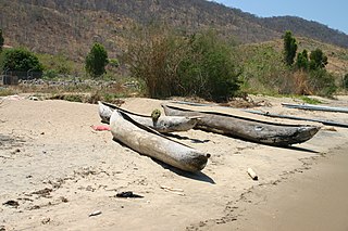
A dugout canoe or simply dugout is a boat made from a hollowed tree. Other names for this type of boat are logboat and monoxylon. Monoxylon (μονόξυλον) is Greek – mono- (single) + ξύλον xylon (tree) – and is mostly used in classic Greek texts. In German, they are called Einbaum. Some, but not all, pirogues are also constructed in this manner.
The Gatun Dam is a large earthen dam across the Chagres River in Panama, near the town of Gatun. The dam, constructed between 1907 and 1913, is a crucial element of the Panama Canal; it impounds the artificial Gatun Lake, which in turn carries ships 33 kilometres (21 mi) of their transit across the Isthmus of Panama. In addition, a hydro-electric generating station at the dam generates electricity which is used to operate the locks and other equipment in the canal.

Tara is a mountain in western Serbia. It is part of the Dinaric Alps and stands at 1,000 to 1,590 m above sea level. The mountain's slopes are clad in dense forests with numerous high-elevation clearings and meadows, steep cliffs, deep ravines carved by the nearby Drina River, and many karst caves. The mountain is a popular tourist centre. Tara National Park encompasses a large part of the mountain. The highest peak is Zborište, at 1,544 m (5,066 ft).

Košutnjak is a park-forest and urban neighborhood of Belgrade, the capital of Serbia. It is divided between in the municipalities of Čukarica and Rakovica. With the adjoining Topčider, it is colloquially styled "Belgrade's oxygen factory". The 1923 Belgrade's general plan, in which one of the main projects regarding the green areas was forestation of the area between Topčider and the city, envisioned a continuous green area Senjak – Topčidersko Brdo – Hajd Park – Topčider – Košutnjak, which was formed by the 1930s. This continual forested area makes the largest "green massif" in the immediate vicinity of Belgrade's urban tissue.

Podrinje is the Slavic name of the Drina river basin, known in English as the Drina Valley. The Drina basin is shared between Bosnia and Herzegovina and Serbia, with majority of its territory being located in Eastern Bosnia, entire Upper Drina course and majority of the Middle course, while the Lower Drina course is shared between two countries,with the river representing border. The part of the Drina basin located in Bosnia and Herzegovina is also called Eastern Bosnia.

Banja Koviljača is a popular tourist spot and spa town located in the city of Loznica, Serbia. Situated on the west border of Serbia by the Drina River and 137 kilometres (85 mi) from Belgrade, it is the oldest spa town in Serbia. As of 2011 census, it has 5,151 inhabitants.
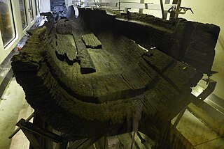
Hasholme logboat is a late Iron Age boat discovered at Hasholme, an area of civil parish of Holme-on-Spalding-Moor in the East Riding of the English county of Yorkshire. It is now on display in the Hull and East Riding Museum, in Hull.

Loznica is a city located in the Mačva District of western Serbia. It lies on the right bank of the Drina river. In 2011 the city had a total population of 19,572, while the administrative area had a population of 79,327.

Lešnica is a village in western Serbia. It is located in the municipality of Loznica, in the Mačva District. Lešnica's current population is 4,731.

The Zasavica is a bog in the region of Mačva, west-central Serbia. It is a major wildlife refuge and one of the last authentically preserved wetlands in Serbia. In the 2000s it became a popular attraction with the successful reintroduction of beavers, which had become extinct 100 years before.

FK Loznica is a professional football club from Loznica, Serbia.

The Drina is a 346 km (215 mi) long Balkans river, which forms a large portion of the border between Bosnia and Herzegovina and Serbia. It is the longest tributary of the Sava River and the longest karst river in the Dinaric Alps which belongs to the Danube river watershed. Its name is derived from the Roman name of the river which in turn is derived from Greek.

Zaovine Lake is an artificial lake in central-west Serbia, on the Tara Mountain. It was created on the Beli Rzav river as a reservoir for the Bajina Bašta II reversible hydro power plant. The lake, with its five bays, have been nicknamed the "Jewel of Tara".

The Tronoša Monastery is a Serbian Orthodox monastery between the villages of Tršić and Korenita, in the administrative town of Loznica, in western Serbia. It is ecclesiastically part of the Eparchy of Šabac. According to tradition, the monastery was built by King Stefan Dragutin.
The Capture of Banja Koviljača was a long battle fought by cooperating forces of Chetniks and Yugoslav Partisans against German forces. On 1 September 1941, the insurgents attacked German soldiers who were garrisoned in an outpost at Banja Koviljača in the German-occupied territory of Serbia. The battle reflected skillful command by leaders of the uprising.

Between 13 and 18 May 2014 a low-pressure cyclone designated Tamara and Yvette affected a large area of Southeastern and Central Europe, causing floods and landslides. Serbia and Bosnia and Herzegovina suffered the greatest damage, as the rain was the heaviest in 120 years of recorded weather measurements. By 20 May, at least 62 people had died as a result of the flooding, and hundreds of thousands had been forced from their homes. Towns of Obrenovac in Serbia and Doboj in Bosnia and Herzegovina account for most victims, after being inundated by several-meter high waters from nearby rivers.

Trešnjica is a river in western Serbia. The source of the river is situated on the Povlen mountain. After 23 km the Trešnjica joins the Drina near Ljubovija.

The Battle of Loznica also known as the Battle of Tičar was fought on 17–18 October 1810 between Serbian Revolutionaries and Ottoman forces in Loznica, at the time part of the Sanjak of Zvornik, a region of the Ottoman Empire,.

Antonije "Anta" Bogićević was a Serbian voivode during the First Serbian Uprising. Songs of his heroic exploits were was sung by the famous guslar Filip Višnjić in the song "Battle of Loznica". Today one of the primary schools in Loznica bears his name.

