
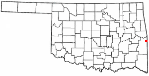
Pushmataha County is a county in the southeastern part of the U.S. state of Oklahoma. As of the 2020 census, the population was 10,812. Its county seat is Antlers.

Le Flore County is a county along the eastern border of the U.S state of Oklahoma. As of the 2020 census, the population was 48,129. Its county seat is Poteau. The county is part of the Fort Smith metropolitan area and the name honors a Choctaw family named LeFlore. The United States District Court for the Eastern District of Oklahoma is the federal district court with jurisdiction in LeFlore County.

Johnston County is a county located in the U.S. state of Oklahoma. As of the 2020 census, the population was 10,272. Its county seat is Tishomingo. It was established at statehood on November 16, 1907, and named for Douglas H. Johnston, a governor of the Chickasaw Nation.

Cameron is a town in Le Flore County, Oklahoma, United States. It is part of the Fort Smith, Arkansas-Oklahoma Metropolitan Statistical Area. The population was 302 at the 2010 census, a decline of 3.2 percent from the figure of 312 recorded in 2000.

Fort Coffee is a town in Le Flore County, Oklahoma, United States. Originally constructed as a U. S. Army fort in 1834, it was named for U. S. General John Coffee, a veteran of the Seminole Wars. It is part of the Fort Smith, Arkansas-Oklahoma Metropolitan Statistical Area. The population was 424 at the 2010 census, a gain of 2.9 percent over the figure of 412 in 2000.

Pocola is a town in Le Flore County, Oklahoma, United States. It is part of the Fort Smith, Arkansas-Oklahoma metropolitan area. The population was 4,056 in 2010, a gain of 1.6 percent over the figure of 3,994 recorded in 2000. Pocola is a Choctaw word meaning "ten", the approximate distance in miles from Fort Smith, Arkansas.
Rock Island is a town in Le Flore County, Oklahoma, United States. It is part of the Fort Smith, Arkansas-Oklahoma Metropolitan Statistical Area. The population was 646 at the 2010 census, a decline of 8.9 percent from the figure of 709 recorded in 2000.

The St. Louis–San Francisco Railway, commonly known as the "Frisco", was a railroad that operated in the Midwest and South Central United States from 1876 to April 17, 1980. At the end of 1970, it operated 4,547 miles (7,318 km) of road on 6,574 miles (10,580 km) of track, not including subsidiaries Quanah, Acme and Pacific Railway and the Alabama, Tennessee and Northern Railroad; that year, it reported 12,795 million ton-miles of revenue freight and no passengers. It was purchased and absorbed into the Burlington Northern Railroad in 1980. Despite its name, it never came close to San Francisco.

The Kiamichi River is a river in southeastern Oklahoma, United States of America. A tributary of the Red River of the South, its headwaters rise on Pine Mountain in the Ouachita Mountains near the Arkansas border. From its source in Polk County, Arkansas, it flows approximately 177 miles (285 km) to its confluence with the Red River at Hugo, Oklahoma.

The Arkansas and Missouri Railroad is a Class III short-line railroad headquartered in Springdale, Arkansas.
The Fort Smith and Western Railway was a railroad that operated in the states of Arkansas and Oklahoma.
Kosoma is a ghost town and former railroad station in Pushmataha County, Oklahoma, United States. It is located just off Oklahoma State Highway 2, approximately 10 miles (16 km) north of Antlers.
Dunbar is a community in Pushmataha County, Oklahoma, United States, 17 miles north of Antlers. Dunbar is located at 34°27′31″N95°33′38″W.
Kiamichi is a former community in northern Pushmataha County, Oklahoma, United States, six miles east of Tuskahoma.
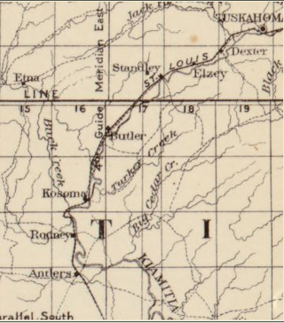
Stanley is an unincorporated community in northern Pushmataha County, Oklahoma, United States. The community is on Oklahoma State Highway 2 seven miles southwest of Clayton. The Kiamichi River flows past the southeast side of the site.
Hamden is an unincorporated community in northern Choctaw County, Oklahoma, United States. It is seven miles southeast of Antlers.
The Arkansas Western Railway operated a 32-mile rail line between Heavener, Oklahoma and Waldron, Arkansas. It bought the assets of its predecessor in 1904, and the company was merged out of existence in 1992.
The Poteau Valley Railroad was a shortline running from Calhoun, Oklahoma to Shady Point, Oklahoma, encompassing 7.883 mi (12.686 km) of track. It began in 1900 and was abandoned in 1926.
Calhoun, originally called Sutter, is an unincorporated community in Le Flore County in the State of Oklahoma, approximately 7 miles northwest of Poteau, the county seat. Located about 6.5 driving miles west-southwest of Shady Point, Oklahoma, Calhoun can be reached off of US Route 59 at Shady Point by heading west on County Road D1310, then County Road 90. The town is just northwest of Cavanal Hill, which makes the eccentric boast of being the “world’s highest hill.”

