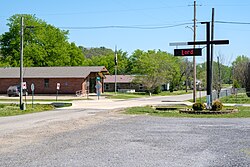
Cameron, Oklahoma

Last updated • 3 min readFrom Wikipedia, The Free Encyclopedia

Cameron, Oklahoma
Kʋlih Chaha (Choctaw)
Cameron, Oklahoma.jpg
OKMap-doton-Cameron.PNG
Location of Cameron, Oklahoma
Coordinates: 35°08′14″N94°32′21″W / 35.13722°N 94.53917°W / 35.13722; -94.53917
Country United States
State Oklahoma
County Le Flore
Area
[1]
  Total1.49 sq mi (3.86 km2)
  Land1.49 sq mi (3.86 km2)
  Water0.00 sq mi (0.00 km2)
Elevation
[2]
495 ft (151 m)
Population
 (2020)
  Total323
  Density216.49/sq mi (83.57/km2)
Time zone UTC-6 (Central (CST))
  Summer (DST) UTC-5 (CDT)
ZIP code
74932
Area code(s) 539/918
FIPS code 40-11300 [3]
GNIS feature ID2413153 [2]

Cameron is a town in Le Flore County, Oklahoma, United States. It is part of the Fort Smith, Arkansas-Oklahoma Metropolitan Statistical Area. The population was 302 at the 2010 census, a decline of 3.2 percent from the figure of 312 recorded in 2000. [4]

Contents

History

When the Fort Smith and Southern Railway laid tracks in the area of the present day town of Cameron in 1886–87, there was already a settlement of about 40 people. [lower-alpha 1] At the time of its founding, Cameron was located in Skullyville County, a part of the Moshulatubbee District of the Choctaw Nation. [6] The U. S. Post Office Department established a post office that it named Cameron, Indian Territory in 1888. According to Encyclopedia of Oklahoma History and Culture, the post office and town may have been named for either of two persons. One was William Cameron, a former Mine Inspector for Indian Territory. The other was James Cameron, an employee of the Fort Smith and Southern Railway. [5]

In 1883, James Reynolds, a successful rancher and entrepreneur, established the Cameron Institute, which was sponsored by the Presbyterian Church but was open to enrolling students of any denomination. It educated children from primary to high school level. Reynolds became a resident of Cameron, where he built an imposing home, now known as the James E. Reynolds House, that had the appearance of a castle. The building is on the National Register of Historic Places listings in LeFlore County, Oklahoma. [5]

Geography

Cameron is located 8 miles (13 km) northeast of Poteau. [5]

According to the United States Census Bureau, the town has a total area of 0.3 square miles (0.78 km2), all land.

Demographics

Historical population
CensusPop.Note
1900 316
1910 206−34.8%
1920 203−1.5%
1930 28339.4%
1940 203−28.3%
1950 2093.0%
1960 2111.0%
1970 31147.4%
1980 36517.4%
1990 327−10.4%
2000 312−4.6%
2010 302−3.2%
2020 3237.0%
U.S. Decennial Census [7]

As of the census [3] of 2000, there were 312 people, 115 households, and 90 families residing in the town. The population density was 1,158.9 inhabitants per square mile (447.5/km2). There were 126 housing units at an average density of 468.0 per square mile (180.7/km2). The racial makeup of the town was 83.65% White, 0.32% African American, 11.54% Native American, and 4.49% from two or more races.

There were 115 households, out of which 35.7% had children under the age of 18 living with them, 53.9% were married couples living together, 15.7% had a female householder with no husband present, and 21.7% were non-families. 20.0% of all households were made up of individuals, and 8.7% had someone living alone who was 65 years of age or older. The average household size was 2.71 and the average family size was 3.11.

In the town, the population was spread out, with 26.6% under the age of 18, 9.3% from 18 to 24, 29.5% from 25 to 44, 23.1% from 45 to 64, and 11.5% who were 65 years of age or older. The median age was 35 years. For every 100 females, there were 113.7 males. For every 100 females age 18 and over, there were 104.5 males.

The median income for a household in the town was $23,750, and the median income for a family was $26,339. Males had a median income of $27,679 versus $17,321 for females. The per capita income for the town was $11,055. About 14.7% of families and 19.6% of the population were below the poverty line, including 32.9% of those under age 18 and 10.5% of those age 65 or over.

Notes

  1. The St. Louis and San Francisco Railway (aka SL&SF, or Frisco) bought the Fort Smith and Southern in February 1887 and completed the line. [5]

Related Research Articles

<span class="mw-page-title-main">LeFlore County, Oklahoma</span> County in Oklahoma, United States

LeFlore County is a county along the eastern border of the U.S state of Oklahoma. As of the 2020 census, the population was 48,129. Its county seat is Poteau. The county is part of the Fort Smith metropolitan area and the name honors a Choctaw family named LeFlore. The United States District Court for the Eastern District of Oklahoma is the federal district court with jurisdiction in LeFlore County.

<span class="mw-page-title-main">Arkoma, Oklahoma</span> Town in Oklahoma, United States

Arkoma is a town in LeFlore County, Oklahoma, United States. It is part of the Fort Smith, Arkansas-Oklahoma Metropolitan Statistical Area. The population was 1,989 at the 2010 census, a decline from 2,180 in 2000. The name of the town is a portmanteau of Arkansas and Oklahoma. Throughout its history, Arkoma has served as a "bedroom community" because many residents commuted to work in Fort Smith.

<span class="mw-page-title-main">Bokoshe, Oklahoma</span> Town in Oklahoma, United States

Bokoshe is a town in Le Flore County, Oklahoma, United States. It is part of the Fort Smith, Arkansas-Oklahoma metropolitan statistical area. Bokoshe is a Choctaw word meaning "little creek". The population was 396 at the 2020 census, a 22.3% decrease over the figure of 510 recorded in 2010.

<span class="mw-page-title-main">Cowlington, Oklahoma</span> Town in Oklahoma, United States

Cowlington is a town in LeFlore County, Oklahoma. It is part of the Fort Smith metropolitan area. The population was 155 at the time of the 2010 census, a gain of 16.5 percent over the figure of 133 recorded in 2000.

<span class="mw-page-title-main">Fort Coffee, Oklahoma</span> Town in Oklahoma, United States

Fort Coffee is a town in Le Flore County, Oklahoma, United States. Originally constructed as a U. S. Army fort in 1834, it was named for U. S. General John Coffee, a veteran of the Seminole Wars. It is part of the Fort Smith, Arkansas-Oklahoma Metropolitan Statistical Area. The population was 424 at the 2010 census, a gain of 2.9 percent over the figure of 412 in 2000.

<span class="mw-page-title-main">Howe, Oklahoma</span> Town in Oklahoma, United States

Howe is a town in Le Flore County, Oklahoma, United States. It is part of the Fort Smith, Arkansas-Oklahoma Metropolitan Statistical Area. The population was 802 at the 2010 census, a gain of 15.1 percent over the figure of 697 recorded in 2000. The town was once noted for producing coal and coke, but today is chiefly supported by agriculture.

<span class="mw-page-title-main">LeFlore, Oklahoma</span> Town in Oklahoma, United States

LeFlore is a town in LeFlore County, Oklahoma, United States. It is part of the Fort Smith, Arkansas-Oklahoma Metropolitan Statistical Area. The population was 198 at the 2010 census, an increase of 13.1 percent over the figure of 168 in 2000. Although the legal town name is spelled in the two-word form, the official federal name for the place and the postal name used is Leflore.

<span class="mw-page-title-main">Panama, Oklahoma</span> Town in Oklahoma, United States

Panama is a town in Le Flore County, Oklahoma, United States. It is part of the Fort Smith, Arkansas-Oklahoma Metropolitan Statistical Area. The population was 1,413 at the 2010 census.

<span class="mw-page-title-main">Pocola, Oklahoma</span> Town in Oklahoma, United States

Pocola is a town in Le Flore County, Oklahoma, United States. It is part of the Fort Smith, Arkansas-Oklahoma metropolitan area. The population was 4,056 in 2010, a gain of 1.6 percent over the figure of 3,994 recorded in 2000. Pocola is a Choctaw word meaning "ten", the approximate distance in miles from Fort Smith, Arkansas.

<span class="mw-page-title-main">Poteau, Oklahoma</span> City in Oklahoma, United States

Poteau is a city in, and county seat of, LeFlore County, Oklahoma, United States. The population was 8,520 as of the 2010 census.

<span class="mw-page-title-main">Rock Island, Oklahoma</span> Town in Oklahoma, United States

Rock Island is a town in Le Flore County, Oklahoma, United States. It is part of the Fort Smith, Arkansas-Oklahoma Metropolitan Statistical Area. The population was 646 at the 2010 census, a decline of 8.9 percent from the figure of 709 recorded in 2000.

<span class="mw-page-title-main">Shady Point, Oklahoma</span> Town in Oklahoma, United States

Shady Point, sometimes referred to as Shadypoint, is a town in Le Flore County, Oklahoma, United States. It is part of the Fort Smith, Arkansas-Oklahoma Metropolitan Statistical Area. The population was 1,026 at the 2010 census, a 21.0 percent increase over the figure of 848 recorded in 2000.

<span class="mw-page-title-main">Spiro, Oklahoma</span> Town in Oklahoma, United States

Spiro is a town in Le Flore County, Oklahoma, United States. It is part of the Fort Smith, Arkansas-Oklahoma Metropolitan Statistical Area. The population was 2,164 at the 2010 census, a 2.8 percent decline from the figure of 2,227 recorded in 2000.

<span class="mw-page-title-main">Talihina, Oklahoma</span> Town in Oklahoma, United States

Talihina is a town in LeFlore County, Oklahoma, United States, its name originating from two Choctaw words, tully and hena, meaning "iron road," a reference to the railroad around which the town was built. It is part of the Fort Smith, Arkansas–Oklahoma Metropolitan Statistical Area. The population was 925 at the time of the 2020 Census.

<span class="mw-page-title-main">Wister, Oklahoma</span> Town in Oklahoma, United States

Wister is a town in Le Flore County, Oklahoma, United States. It is part of the Fort Smith metropolitan area. The population was 1,102 at the 2010 census. Wister is named for Gutman G. Wister, an official with the Choctaw, Oklahoma and Gulf Railroad.

<span class="mw-page-title-main">Weleetka, Oklahoma</span> Town in Oklahoma, United States

Weleetka is a town in Okfuskee County, Oklahoma, United States. It is approximately 10 miles (16 km) southeast of Okemah, the county seat. The name is a Creek word meaning "running water." The population was 806 at the time of the 2020 census.

<span class="mw-page-title-main">Indianola, Pittsburg County, Oklahoma</span> Town in Oklahoma, United States

Indianola is a town in Pittsburg County, Oklahoma, United States. The population was 162 at the 2010 census, a loss of 15.2 percent compared to 191 at the 2000 census.

<span class="mw-page-title-main">Gore, Oklahoma</span> Town in Oklahoma, United States

Gore is a town in western Sequoyah County, Oklahoma, United States. It is part of the Fort Smith, Arkansas-Oklahoma Metropolitan Statistical Area. The population was 977 at the 2010 census, an increase of 15 percent over the figure of 850 recorded in 2000.

<span class="mw-page-title-main">Roland, Oklahoma</span> Town in Oklahoma, United States

Roland is a town in Sequoyah County, Oklahoma, United States. It is part of the Fort Smith, Arkansas-Oklahoma Metropolitan Statistical Area. The population was 3,169 at the 2010 census, compared to the figure of 2,842 recorded in 2000.

<span class="mw-page-title-main">Fanshawe, Oklahoma</span> Town in Oklahoma, United States

Fanshawe is a town in Latimer and Le Flore counties in the U.S. state of Oklahoma. As of the 2020 Census, the town had a total population of 317. The Le Flore County portion of Fanshawe is part of the Fort Smith, Arkansas-Oklahoma Metropolitan Statistical Area.

References

  1. "ArcGIS REST Services Directory". United States Census Bureau. Archived from the original on January 19, 2022. Retrieved September 20, 2022.
  2. 1 2 U.S. Geological Survey Geographic Names Information System: Cameron, Oklahoma
  3. 1 2 "U.S. Census website". United States Census Bureau. Archived from the original on July 9, 2021. Retrieved January 31, 2008.
  4. Archived June 15, 2013, at the Wayback Machine CensusViewer: Cameron, Oklahoma Population. Retrieved September 14, 2012.
  5. 1 2 3 4 Larry O'Dell, "Cameron." Encyclopedia of Oklahoma History and Culture. Archived April 2, 2015, at the Wayback Machine Accessed March 20, 2015.
  6. Morris, John W. Historical Atlas of Oklahoma (Norman: University of Oklahoma, 1986), plate 38.
  7. "Census of Population and Housing". Census.gov. Archived from the original on March 21, 2021. Retrieved June 4, 2015.