Indian Territory and the Indian Territories are terms that generally described an evolving land area set aside by the United States government for the relocation of Native Americans who held original Indian title to their land as an independent nation-state. The concept of an Indian territory was an outcome of the U.S. federal government's 18th- and 19th-century policy of Indian removal. After the American Civil War (1861–1865), the policy of the U.S. government was one of assimilation.

Montague County is a county located in the U.S. state of Texas, established in 1857. As of the 2020 census, its population was 19,965. The county seat is Montague. The county was created in 1857 and organized the next year. It is named for Daniel Montague, a surveyor and soldier in the Mexican–American War.

The Battle of the Washita River occurred on November 27, 1868, when Lt. Col. George Armstrong Custer's 7th U.S. Cavalry attacked Black Kettle's Southern Cheyenne camp on the Washita River.

David Lewis Payne was an American soldier and pioneer. Payne is considered by some to be the "Father of Oklahoma" for his work in opening the state to settlement.
John Horton Slaughter, also known as Texas John Slaughter, was an American lawman, cowboy, poker player and rancher in the Southwestern United States during the late 19th and early 20th centuries. After serving in the Confederate States Army during the American Civil War, Slaughter earned a reputation fighting hostile Indians and Mexican and American outlaws in the Arizona and New Mexico territories. In the latter half of his life, he lived at the San Bernardino Ranch, which is today a well-preserved National Historic Landmark in Cochise County in far southeastern Arizona. In 1964, he was inducted into the Hall of Great Westerners of the National Cowboy & Western Heritage Museum.

The Cherokee Outlet, or Cherokee Strip, was located in what is now the state of Oklahoma in the United States. It was a 60-mile-wide (97 km) parcel of land south of the Oklahoma–Kansas border between 96 and 100°W. The Cherokee Outlet was created in 1836. The United States forced the Cherokee Nation of Indians to cede to the United States all lands east of the Mississippi River in exchange for a reservation and an "outlet" in Indian Territory. At the time of its creation, the Cherokee Outlet was about 225 miles (360 km) long. The cities of Enid, Woodward, Ponca City, and Perry were later founded within the boundaries of what had been the Cherokee Outlet.

The Chisholm Trail was a trail used in the post-Civil War era to drive cattle overland from ranches in southern Texas, crossed the Red River into Indian Territory, and ended at Kansas rail stops. The trail encompassed a pathway established by Black Beaver in 1861, and a wagon road established by Jesse Chisholm around 1864. "The Chisholm Wagon Road went from Chisholm's trading post on the South Canadian (north of Fort Arbuckle to the Cimarron River crossing, to the Arkansas River at the future site of Wichita where Chisholm had another trading post and on north to Abilene," according to the Kraisingers. By 1869, the entire trail from Texas to Kansas became known as the Chisholm Trail.
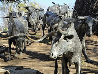
The Texas Road, also known as the Shawnee Trail, or Shawnee-Arbuckle Trail, was a major trade and emigrant route to Texas across Indian Territory. Established during the Mexican War by emigrants rushing to Texas, it remained an important route across Indian Territory until Oklahoma statehood. The Shawnee Trail was the earliest and easternmost route by which Texas Longhorn cattle were taken to the north. It played a significant role in the history of Texas, Oklahoma, Missouri, and Kansas in the early and mid-1800s.
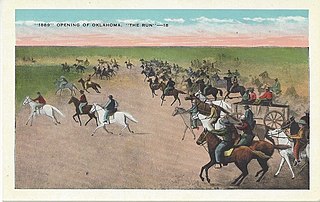
The Oklahoma Land Rush of 1889 was the first land run into the Unassigned Lands of the former western portion of the federal Indian Territory, which had decades earlier since the 1830s been assigned to the Creek and Seminole native peoples. The area that was opened to settlement included all or part of the Canadian, Cleveland, Kingfisher, Logan, Oklahoma, and Payne counties of the present-day U.S. state of Oklahoma.

Fort Gibson is a historic military site next to the modern city of Fort Gibson, in Muskogee County Oklahoma. It guarded the American frontier in Indian Territory from 1824 to 1888. When it was constructed, the fort was farther west than any other military post in the United States. It formed part of the north–south chain of forts that was intended to maintain peace on the frontier of the American West and to protect the southwestern border of the Louisiana Purchase. The fort succeeded in its peacekeeping mission for more than 50 years, as no massacres or battles occurred there.

Cattle drives were a major economic activity in the 19th and early 20th century American West, particularly between 1850s and 1910s. In this period, 27 million cattle were driven from Texas to railheads in Kansas, for shipment to stockyards in St. Louis and points east, and direct to Chicago. The long distances covered, the need for periodic rests by riders and animals, and the establishment of railheads led to the development of "cow towns" across the frontier.

The Great Western Cattle Trail is the name used today for a cattle trail established during the late 19th century for moving beef stock and horses to markets in eastern and northern states. It ran west of and roughly parallel to the better known Chisholm Trail into Kansas, reaching an additional major railhead there for shipping beef to Chicago, or longhorns and horses continuing on further north by trail to stock open-range ranches in the Dakotas, Wyoming, Montana in the United States, and Alberta and Saskatchewan in Canada.

During the American Civil War, most of what is now the U.S. state of Oklahoma was designated as the Indian Territory. It served as an unorganized region that had been set aside specifically for Native American tribes and was occupied mostly by tribes which had been removed from their ancestral lands in the Southeastern United States following the Indian Removal Act of 1830. As part of the Trans-Mississippi Theater, the Indian Territory was the scene of numerous skirmishes and seven officially recognized battles involving both Native American units allied with the Confederate States of America and Native Americans loyal to the United States government, as well as other Union and Confederate troops.
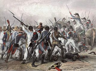
The 1842 Slave Revolt in the Cherokee Nation was the largest escape of a group of slaves to occur in the Cherokee Nation, in what was then Indian Territory. The slave revolt started on November 15, 1842, when a group of 20 African-Americans enslaved by the Cherokee escaped and tried to reach Mexico, where slavery had been abolished in 1829. Along their way south, they were joined by 15 slaves escaping from the Creek Nation in Indian Territory.

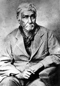
Black Beaver or Se-ket-tu-may-qua was a trapper and interpreter who worked for the American Fur Company. He served as a scout and guide as he was fluent in English, as well as several European and Native American languages. He is credited with establishing the California and Chisholm trails.
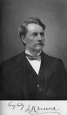
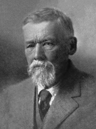
James R. Mead was a plainsman, Kansas pioneer, one of the founders of Wichita, Kansas and state legislator. He was active in seeking to protect the rights of the Kansas Indian tribes. He aided in directing the cattle drives along the Chisholm Trail to the city. In 1871, he was instrumental in bringing the Wichita & Southwestern Railroad to Wichita. He possessed a lifelong interest in biology and ethnology. Later in life, he wrote articles for the Kansas State Historical Society and for the Kansas Academy of Science. His memoirs were published in the book, Hunting and Trading on the Great Plains 1859-1875 [Rowfant Press 2008, ISBN 978-1-929731-07-7].
The history of Cleveland County, Oklahoma refers to the history of a county in the U.S. state of Oklahoma, and the land on which it developed prior to 1907 statehood. Prior to European colonization, the land represented the edge of the domain of the Plains Indians. France and Spain both colonized and explored the area before it became part of the United States via the Louisiana Purchase. It became part of the territory of the United States and tribal land and eventually part of the U.S. state of Oklahoma.
Montford T. Johnson was Chickasaw and a cattleman who lived in Indian Territory, what is now the present-day state of Oklahoma. Johnson was a well-known and respected entrepreneur, noted for his successful ranching operation that spanned a large area of central Oklahoma, including parts of what would eventually become Oklahoma City.
John DeBras Miles was an American Indian agent at the Kickapoo people Agency and at the Darlington Agency for the Cheyenne and Arapaho.
Dianna Rogers was an Old Settler Cherokee who emigrated from Tennessee to the Arkansas Territory in 1817. Her first husband was killed in the Osage wars with the Cherokee people. Forced to move further west in 1828 into what would become Indian Territory her extended family, which included John Rogers and John Jolly, lived in what is now the northeastern part of Oklahoma, along the Arkansas border. In 1829, she married Sam Houston and operated a trading post with him near Fort Gibson. She also tended their small farm and the slaves who assisted them. After Houston left for Texas in 1833, Dianna remarried. She left no living children. Many myths and fanciful stories have been told of her and Houston's relationship, their meeting, and eventual parting, but very little is actually known. A body purported to be hers, but disputed by several historians, was exhumed and buried at the Fort Gibson National Cemetery in 1904. The tombstone bears the name Talahina, which according to legal documents and historians' analysis was never her name.