Jessie, South Australia

Last updated

Jessie
South Australia

Hundred of Jessie, 1872 (22748856390).jpg

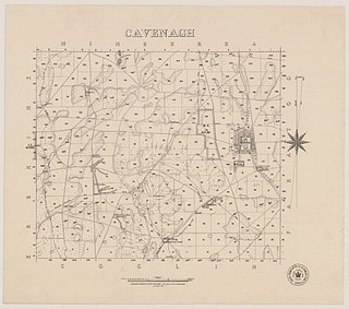
Drawing of the Hundred of Jessie, circa 1872, showing the proposed location and layout of the Town of Jessie
Australia South Australia location map.svg
Red pog.svg
Jessie
Coordinates 36°58′18″S140°57′56″E / 36.971639°S 140.965434°E / -36.971639; 140.965434 Coordinates: 36°58′18″S140°57′56″E / 36.971639°S 140.965434°E / -36.971639; 140.965434 [1]
Established by 1870 [2]
Abolished 24 January 1929 [3]
Area 100 hectares (250 acres) [4]
Location
LGA(s) District Council of Naracoorte
County Robe [1]

Jessie was a town in the Australian state of South Australia whose site is located about 311 kilometres (193 mi) south-east of the state capital of Adelaide and about 20 kilometres (12 mi) east of the former municipal seat of Naracoorte at the border with the state of Victoria. [1]

South Australia State of Australia

South Australia is a state in the southern central part of Australia. It covers some of the most arid parts of the country. With a total land area of 983,482 square kilometres (379,725 sq mi), it is the fourth-largest of Australia's states and territories by area, and fifth largest by population. It has a total of 1.7 million people, and its population is the second most highly centralised in Australia, after Western Australia, with more than 77 percent of South Australians living in the capital, Adelaide, or its environs. Other population centres in the state are relatively small; Mount Gambier, the second largest centre, has a population of 28,684.

Adelaide city centre Suburb of Adelaide, South Australia

Adelaide city centre is the innermost locality of Greater Adelaide, the capital city of South Australia. It is known by locals simply as "The City" or "Town" to distinguish it from Greater Adelaide and from the City of Adelaide. The locality is split into two key geographical distinctions: the city "square mile", bordered by North, East, South and West Terraces; and the section of the parklands south of the River Torrens which separates the built up part of the city from the surrounding suburbs and North Adelaide.

Naracoorte, South Australia Town in South Australia

Naracoorte is a town in the Limestone Coast region of South Australia, approximately 336 kilometres south-east of Adelaide and 100 kilometres north of Mount Gambier on the Riddoch Highway (A66).

It was in the cadastral unit of the Hundred of Jessie on land with an estimated area of 100 hectares (250 acres). Upon the proclamation of the District Councils Act 1887 on 9 December 1887, it was located within the jurisdiction of the District Council of Narracoorte. [5] [4]

The District Councils Act 1887 was an act of the Parliament of South Australia. It received assent on 9 December 1887, and its provisions came into effect when proclaimed by Governor William C. F. Robinson on 5 January 1888.

The source of the town’s name is not reported in official sources. [1] An article in The Narracoorte Herald of 22 February 1929 does offer two possible opinions to the sources of the town’s name. The first was that "many South-Eastern people thought it was named after a sister of the late Mr. J. P. D. Laurie" who may have had "some influence with the Crown Lands Department" in respect to its name. The second was that it was named after "some other lady" on the basis of the views of "some other historians of nomenclature." This lady could be Lady Jessie Blyth for whom the Hundred of Jessie was named. Lady Blyth was the wife of Sir Arthur Blyth, Commissioner of Crown Land and a former Premier of South Australia when the Hundred was proclaimed on 24 October 1867. [6] [7] [4]

James Park Dawson Laurie, generally known as "Park Laurie", was a pastoralist and politician in the colony of South Australia.

Arthur Blyth Australian politician

Sir Arthur Blyth was Premier of South Australia three times; 1864–65, 1871–72 and 1873–75.

Premier of South Australia Wikimedia List

The Premier of South Australia is the head of government in the state of South Australia, Australia. The Government of South Australia follows the Westminster system, with a Parliament of South Australia acting as the legislature. The Premier is appointed by the Governor of South Australia, and by modern convention holds office by virtue of his or her ability to command the support of a majority of members of the lower house of Parliament, the House of Assembly.

Jessie is reported as being proclaimed on 28 April 1876 by one source while official sources such as the South Australian Government Gazette contain no mention of any proclamation. [7] However, the government gazette does show that land within the town was available for purchase by November 1870 at the latest. [2] A drawing of the Hundred of Jessie prepared in November 1872 by the surveyor-general’s office shows that the town had been located and that a layout of its allotments and streets had been prepared. [8] The town is reported as being surveyed during May 1890. [1] In September 1891, during the second reading of The Park Lands Resumption Bill in the South Australian House of Assembly, it was stated that the town allotments in the Town of Jessie all remained unsold and that there were "no occupants on town lots" while the "suburban lands" had been "nearly all sold." [9]

The South Australian Government Gazette is the government gazette of the South Australian Government. First printed on 20 June 1839, the South Australian Government chose to have its own publication rather than using the local newspaper, South Australian Gazette and Colonial Register because the publishers were perceived as politically biased. The purpose was to publish government orders and acts with authority of the colonial secretary. Initially it was called South Australian Gazette.

South Australian House of Assembly lower house of the Parliament of South Australia

The House of Assembly, or lower house, is one of the two chambers of the Parliament of South Australia. The other is the Legislative Council. It sits in Parliament House in the state capital, Adelaide.

On 24 January 1929, the town was declared by a proclamation under the Crown Lands Act 1915 to "ceased to exist" along with the closure of all roads within its boundaries. [3]

On 12 April 2001, the site of the ceased town was divided along the alignment of the Wimmera Highway with its north and south sides being allocated respectively to the newly created localities of Hynam and Laurie Park. [1] [10]

Wimmera Highway highway in Victoria and South Australia

Wimmera Highway is a 345 kilometre highway that connects the towns of Marong, Victoria and Naracoorte, South Australia, through the major junctions of Sunraysia Highway, Henty Highway and Western Highway.

Hynam, South Australia Town in South Australia

Hynam is a town and locality in the Australian state of South Australia located in the state's south-east within the Limestone Coast region on the border with the state of Victoria about 302 kilometres south east of the state capital of Adelaide and about 11 kilometres east of the municipal seat of Naracoorte.

Laurie Park, South Australia Town in South Australia

Laurie Park is a locality located within the Naracoorte Lucindale Council in the Limestone Coast region of South Australia.

Related Research Articles

Billiatt Conservation Park Protected area in South Australia

Billiatt Conservation Park is a protected area in South Australia midway between Alawoona and Lameroo, approximately 200 km east of Adelaide city centre.

Hacks Lagoon Conservation Park Protected area in South Australia

Hacks Lagoon Conservation Park is a protected area in the Australian state of South Australia located in the locality of Bool Lagoon about 24 kilometres south of the municipal seat of Naracoorte.

Bool Lagoon Game Reserve Protected area in South Australia

Bool Lagoon Game Reserve is a protected area located in the Limestone Coast region of South Australia, about 24 kilometres south of the town of Naracoorte.

Fairview Conservation Park Protected area in South Australia

Fairview Conservation Park is a protected area in the Australian state of South Australia located in the gazetted locality of Woolumbool about 17 kilometres (11 mi) north of Lucindale in the state's Limestone Coast region.

Everard Central, South Australia Town in South Australia

Everard Central is a locality in South Australia's Mid North. The locality is situated in approximately the southern two thirds of the cadastral Hundred of Everard.

Hundred of Cameron Cadastral in South Australia

The Hundred of Cameron is a cadastral unit of hundred located in the Mid North of South Australia centred on Lake Bumbunga. The northern Hummock Range occupies much of the western half of the area and the Adelaide-Port Augusta railway line runs near and parallel to the eastern boundary. It is one of the 16 hundreds of the County of Daly. It was named in 1869 by Governor James Fergusson for early pioneer Hugh Cameron.

Keppoch, South Australia Suburb of Naracoorte Lucindale Council, South Australia

Keppoch is a locality in the Australian state of South Australia located in the state's south-east within the Limestone Coast region about 269 kilometres south east of the state capital of Adelaide and about 29 kilometres north-east of the municipal seat of Naracoorte.

Big Heath Conservation Park Protected area in South Australia

Big Heath Conservation Park is a protected area in the Australian state of South Australia located in the gazetted locality of Spence about 20 kilometres (12 mi) south-west of Naracoorte in the state's Limestone Coast region.

Boondina Conservation Park Protected area in South Australia

Boondina Conservation Park is a protected area in the Australian state of South Australia located in the west of the state in the gazetted locality of Yellabinna about 38 kilometres (24 mi) north-east of the town centre in Fowlers Bay.

Bangham Conservation Park Protected area in South Australia

Bangham Conservation Park is a protected area in the Australian state of South Australia located in the state's Limestone Coast in the gazetted locality of Bangham about 45 kilometres (28 mi) north-east of the town centre in Naracoorte.

Amyton, South Australia Suburb of Mount Remarkable , South Australia

Amyton is a locality in the Australian state of South Australia located on the eastern side of the Flinders Ranges about 259 kilometres (161 mi) north of the state capital of Adelaide and about 28 kilometres (17 mi) north-east of the municipal seat of Melrose.

Stephenston, South Australia Suburb of Flinders Ranges Council , South Australia

Stephenston is a locality in the Australian state of South Australia located on the eastern side of the Flinders Ranges about 285 kilometres (177 mi) north of the state capital of Adelaide and about 15 kilometres (9.3 mi) east of the municipal seat of Quorn.

Moockra, South Australia Suburb of Flinders Ranges , South Australia

Moockra is a locality in the Australian state of South Australia located on the eastern side of the Flinders Ranges about 274 kilometres (170 mi) north of the state capital of Adelaide and about 47 kilometres (29 mi) north-east and 36 kilometres (22 mi) south-east respectively of the municipal seats of Melrose and Quorn.

Bandon Conservation Park Protected area in South Australia

Bandon Conservation Park is a protected area located in the Australian state of South Australia in the locality of Copeville about 130 kilometres (81 mi) east of the state capital of Adelaide and about 16 kilometres (9.9 mi) east of the town of Copeville.

Caroona Creek Conservation Park Protected area in South Australia

Caroona Creek Conservation Park is a protected area located in the Australian state of South Australia in the localities of Collinsville and Mount Bryan East about 173 kilometres (107 mi) north-east of the state capital of Adelaide and about 19 kilometres (12 mi) east of the town of Hallett.

Woakwine Conservation Park Protected area in South Australia

Woakwine Conservation Park is a protected area located in the Australian state of South Australia in the locality of Robe about 272 kilometres (169 mi) south-east of the state capital of Adelaide and about 8 kilometres (5.0 mi) east of the town centre in Robe.

Cavenagh, South Australia Suburb of District Council of Peterborough, South Australia

Cavenagh is a locality in the Australian state of South Australia located about 247 kilometres (153 mi) north of the state capital of Adelaide and about 37 kilometres (23 mi) north-east of the municipal seat in Peterborough.

References

  1. 1 2 3 4 5 6 "Search results for 'Jessie, GTWN' with the following datasets selected - 'Suburbs and Localities', 'Government Towns', 'Roads' and 'Gazetteer'". Location SA Map Viewer. South Australian Government. Retrieved 24 February 2018.
  2. 1 2 Blyth, Arthur (6 October 1870). "Land Sale, 10th November, 1870" (PDF). South Australian Government Gazette. South Australian Government. p. 1326. Retrieved 5 March 2018.
  3. 1 2 Tassie, H. (24 January 1929). "TOWN OF JESSIE TO CEASE TO EXIST" (PDF). South Australian Government Gazette. South Australian Government. p. 153. Retrieved 24 February 2018.
  4. 1 2 3 "The Death of the Township of Jessie". The Narracoorte Herald . LI, (5,462). South Australia. 22 February 1929. p. 4. Retrieved 24 February 2018 via National Library of Australia.
  5. "The District Councils Act 1887 No. 419, The Second Schedule" (PDF). South Australian Government. 9 December 1887. p. 90. Retrieved 5 March 2018.
  6. "Search results for 'Hundred of Jessie, HD' with the following datasets selected - 'Suburbs and Localities', 'Government Towns', 'Hundreds' and 'Gazetteer'". Location SA Map Viewer. South Australian Government. Retrieved 5 March 2018.
  7. 1 2 Manning, Geoffrey. "South Australian Names - J" (PDF). Manning Index of South Australian History. State Library of South Australia. Retrieved 5 March 2018.
  8. "Hundred of Jessie, 1872". Wikimedia. 26 October 2017. Retrieved 5 March 2018.
  9. "TUESDAY, SEPTEMBER 29, 1891". The Narracoorte Herald . XVI, (1.409). South Australia. 29 September 1891. p. 2. Retrieved 24 February 2018 via National Library of Australia.
  10. "GEOGRAPHICAL NAMES ACT 1991 Notice to Assign a Boundary to a Place (to areas within the Naracoorte Lucindale Council)" (PDF). South Australian Government Gazette. South Australian government. 12 April 2001. p. 1587. Retrieved 24 February 2018.