Hynam, South Australia

Last updated

Hynam
South Australia
Australia South Australia location map.svg
Red pog.svg
Hynam
Coordinates 36°56′28″S140°51′17″E / 36.941188°S 140.854728°E / -36.941188; 140.854728 Coordinates: 36°56′28″S140°51′17″E / 36.941188°S 140.854728°E / -36.941188; 140.854728 [1]
Population
Established10 June 1909 (town)
12 April 2001 (locality) [1] [4] [5]
Postcode(s) 5262 [6]
Elevation78 m (256 ft)(railway station) [7]
Time zone ACST (UTC+9:30)
 • Summer (DST) ACST (UTC+10:30)
Location
LGA(s) Naracoorte Lucindale Council [1]
Region Limestone Coast [1]
County Robe [1]
State electorate(s) MacKillop [8]
Federal division(s) Barker [9]
Mean max temp [10] Mean min temp [10] Annual rainfall [10]
21.7 °C
71 °F
8.1 °C
47 °F
490.5 mm
19.3 in
Localities around Hynam:
Wild Dog Valley Kybybolite Apsley, Victoria
Wild Dog Valley
Naracoorte
Mount Light
Hynam Apsley, Victoria
Mount Light Koppamurra
Laurie Park
Apsley, Victoria
Laurie Park
FootnotesLocations [6]
Adjoining localities [1] [11]

Hynam (formerly Hynam East) is a town and locality in the Australian state of South Australia located in the state's south-east within the Limestone Coast region on the border with the state of Victoria about 302 kilometres (188 miles) south east of the state capital of Adelaide and about 11 kilometres (6.8 miles) east of the municipal seat of Naracoorte. [1] [6]

Hynam began as a government town proclaimed as Hynam East on 10 June 1909. It is located adjacent to the Hynam Railway Station and consisted of two parts which were respectively placed on the north and south sides of the railway line. Its name was 'altered' to 'Hynam' on 20 February 1941. Boundaries for the locality of Hynam were created on 12 April 2001. Its boundaries include the Government Town of Hynam and northern part of the site of the ceased Government Town of Jessie. [1] [4] [12] [5]

Hynam was on the Mount Gambier railway line between Wolseley and Mount Gambier, South Australia which closed on 12 April 1995.[ citation needed ]

The 2016 Australian census which was conducted in August 2016 reports that the part of Hynam north of the Wimmera Highway in the east and the unsealed roads of Nolans and Parsons in the west, had a population of 151 people while the part of Hynam south of the above-mentioned roads shared 61 people with the locality of Laurie Park. [2] [1]

Hynam is located within the federal division of Barker, the state electoral district of MacKillop and the local government area of the Naracoorte Lucindale Council. [9] [1] [8]

Related Research Articles

<span class="mw-page-title-main">Naracoorte, South Australia</span> Town in South Australia

Naracoorte is a town in the Limestone Coast region of South Australia, approximately 336 kilometres south-east of Adelaide and 100 kilometres north of Mount Gambier on the Riddoch Highway (A66).

<span class="mw-page-title-main">Bordertown, South Australia</span> Town in South Australia

Bordertown, formerly Border Town, is a town and locality in the Australian state of South Australia located in the state's east near the state border with Victoria about 250 kilometres (160 mi) east of the state capital of Adelaide. It is where the Dukes Highway and the railway line cross the Tatiara Creek between Adelaide and Melbourne, the capital of Victoria.

<span class="mw-page-title-main">Kalangadoo, South Australia</span> Town in South Australia

Kalangadoo, formerly Kalangadoo East, is a locality in the Australian state of South Australia located about 348 kilometres (216 mi) south-east of the state capital of Adelaide and about 31 kilometres (19 mi) north of the regional centre of Mount Gambier.

<span class="mw-page-title-main">Wolseley, South Australia</span> Town in South Australia

Wolseley is a small South Australian town near the Victorian border. It is five kilometres south of the Dukes Highway and 13 kilometres east of Bordertown. It was first proclaimed a town in 1884.

<span class="mw-page-title-main">Lucindale, South Australia</span> Town in South Australia

Lucindale is a small town in the south-east region of South Australia. The town is located 345 kilometres (214 mi) south east of the state capital, Adelaide. At the 2006 census, Lucindale had a population of 301. The town is best known for hosting the annual South East Field Days, attracting over 26,000 visitors every March.

<span class="mw-page-title-main">Avenue Range, South Australia</span> Town in South Australia

Avenue Range is a locality in the Australian state of South Australia located in the state's south-east within the Limestone Coast region about 265 kilometres south east of the Adelaide city centre.

<span class="mw-page-title-main">Binnum, South Australia</span> Town in South Australia

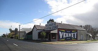
Binnum is a locality in the Australian state of South Australia.

<span class="mw-page-title-main">Frances, South Australia</span> Town in South Australia

Frances is a town in the Australian state of South Australia located about 291 kilometres (181 mi) south-east of the state capital, Adelaide and about 40 kilometres (25 mi) north-east of the municipal seat of Naracoorte in the state's Limestone Coast region and adjoining the border with the State of Victoria.

<span class="mw-page-title-main">Kybybolite</span> Town in South Australia

Kybybolite is a locality in the Australian state of South Australia located in the state's south-east within the Limestone Coast region on the border with the state of Victoria about 301 kilometres south east of the state capital of Adelaide and about 19 kilometres north-east of the municipal seat of Naracoorte.

Victoria was an electorate in the South Australian House of Assembly from 1857 until 1902 and from 1915 to 1993.

Wrattonbully is a locality located within the Naracoorte Lucindale Council in the Limestone Coast in the south east of South Australia about 327 kilometres south east of the Adelaide city centre. Wrattonbully gives its name to the wine region surrounding it, the Wrattonbully wine region.

<span class="mw-page-title-main">Bool Lagoon, South Australia</span> Suburb of Naracoorte Lucindale Council, Wattle Range Council, South Australia

Bool Lagoon is a locality in the Australian state of South Australia located in the south-east of the state in the Limestone Coast region about 311 kilometres south east of the state capital of Adelaide.

Keppoch is a locality in the Australian state of South Australia located in the state's south-east within the Limestone Coast region about 269 kilometres south east of the state capital of Adelaide and about 29 kilometres north-east of the municipal seat of Naracoorte.

Cadgee is a locality in the Australian state of South Australia located in the state's south-east within the Limestone Coast region about 280 kilometres south east of the state capital of Adelaide and about 18 kilometres north of the municipal seat of Naracoorte.

Stewart Range is a locality in the Australian state of South Australia located about 289 kilometres (180 mi) south-east of the state capital of Adelaide and about 12 kilometres (7.5 mi) west of the municipal seat of Naracoorte.

<span class="mw-page-title-main">Joanna, South Australia</span> Town in South Australia

Joanna is a locality in the Australian state of South Australia located in the state's south-east within the state’s Limestone Coast region about 325 kilometres south east of the state capital of Adelaide, about 19.5 kilometres south-east of the municipal seat of Naracoorte.

Coles is a locality in the Australian state of South Australia located in the state's south-east within the Limestone Coast region about 316 kilometres (196 mi) south east of the state capital of Adelaide and about 39 kilometres (24 mi) south-west of the municipal seat of Naracoorte.

Fox is a locality in the Australian state of South Australia located in the state's south-east within the Limestone Coast region about 298 kilometres (185 mi) south east of the state capital of Adelaide and about 45 kilometres (28 mi) south-west of the municipal seat of Naracoorte.

Laurie Park is a locality located within the Naracoorte Lucindale Council in the Limestone Coast region of South Australia.

Clay Wells is a locality in the Australian state of South Australia located in the state's south-east within the Limestone Coast region about 300 kilometres (190 mi) south east of the state capital of Adelaide, and about 39 kilometres (24 mi) south-east and about 35 kilometres (22 mi) north-west respectively of the municipal seats of Robe and Millicent.

References

Notes
  1. For the 2016 census, the 'State Suburb of Hynam' consisted of the northern part of the locality of Hynam. The southern boundary of the state suburb follows road alignments which include the northern boundaries of Mount Light in the west and Laurie Park in the east. [2] [1]
  2. For the 2016 census, the 'State Suburb of Laurie Park' consisted of the southern part of the locality of Hynam and all of Laurie Park. [3] [1]
Citations
  1. 1 2 3 4 5 6 7 8 9 10 11 12 "Search results for 'Hynam, LOCB' with the following datasets being selected – 'NPW and Conservation Properties'. 'Suburbs and Localities', 'Government Towns', 'Counties', 'Local Government Areas', 'SA Government Regions', 'Gazetteer', 'Railways' and 'Roads'". Location SA Map Viewer. Government of South Australia. Retrieved 1 July 2018.
  2. 1 2 3 Australian Bureau of Statistics (27 June 2017). "Hynam (State Suburb)". 2016 Census QuickStats. Retrieved 24 February 2018. OOjs UI icon edit-ltr-progressive.svg
  3. 1 2 Australian Bureau of Statistics (27 June 2017). "Laurie Park (State Suburb)". 2016 Census QuickStats. Retrieved 24 February 2018. OOjs UI icon edit-ltr-progressive.svg
  4. 1 2 "TOWN OF HYNAM EAST" (PDF). The South Australian Government Gazette. South Australian Government. 10 June 1909. p. 225. Retrieved 24 February 2018.
  5. 1 2 "GEOGRAPHICAL NAMES ACT 1991 Notice to Assign a Boundary to a Place (to areas within the Naracoorte Lucindale Council)" (PDF). South Australian Government Gazette. South Australian government. 12 April 2001. p. 1587. Retrieved 24 February 2018.
  6. 1 2 3 "Postcode for Hynam, South Australia". Postcodes Australia. postcodes-australia.com. Retrieved 1 July 2018.
  7. "Search result for 'Hynam Railway Station' with the following datasets selected - 'Suburbs and Localities', 'Government Towns', 'Gazetteer' and 'Railways'". Location SA Map Viewer. South Australian government. Retrieved 1 July 2018.
  8. 1 2 "District of MacKillop Background Profile". Electoral Commission SA. Retrieved 12 April 2016.
  9. 1 2 "Federal electoral division of Barker" (PDF). Australian Electoral Commission. Retrieved 28 March 2016.
  10. 1 2 3 "Naracoorte Aerodrome (nearest weather station)". Climate statistics for Australian locations. Bureau of Meteorology. 1 July 2018. Retrieved 1 July 2018.
  11. "WEST WIMMERA SHIRE, TOWN AND RURAL DISTRICT NAMES AND BOUNDARIES" (PDF). he State of Victoria, Department of Sustainability and Environment. 2007. Retrieved 25 February 2018.
  12. "ALTERATION OF NAMES OF TOWNS AND PLACES" (PDF). The South Australian Government Gazette. South Australian Government. 20 February 1941. p. 225. Retrieved 24 February 2018.