Jesus Lock

Last updated

Jesus Lock on the River Cam at Jesus Green. JesusGreenLock-Cambridge.jpg
Jesus Lock on the River Cam at Jesus Green.
The lock and footbridge during flooding in 2001. Jesus Lock and footbridge.jpg
The lock and footbridge during flooding in 2001.

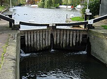
Jesus Lock is a lock on the River Cam in the north of central Cambridge, England. [1] [2] [3] This is Lock No. 1 on the navigable portion of the River Cam. [4] It was built in 1836 and is the only lock in the city. [5] Jesus Green Lock Cottage, the former lock-keeper's cottage, is by the lock on Jesus Green. It is owned by the Conservators of the River Cam and is rented out to students. [6] [7]

Contents

The lock is located north of Jesus Green, which itself is north of Jesus College, hence the name. To the north of Jesus Lock is Chesterton Road (the A1303). To the east (downstream) is Victoria Avenue Bridge on Victoria Avenue and beyond that Midsummer Common, common land still used for grazing. Close by just downstream is Jesus Green Swimming Pool, a very long outdoor lido. [4]

The stretch of river northeast (downstream) of Jesus Lock is sometimes called the lower river. The stretch between Jesus Lock and Baits Bite Lock is much used for rowing. There are also many residential boats on this stretch, their occupants forming a community who call themselves the Camboaters. [8] The stretch above Jesus Lock is sometimes known as the middle river. [9]

Footbridge

Jesus Lock footbridge on the Cam links Chesterton Road with Jesus Green for pedestrians next to the lock. [10] [11] The bridge has metal trellis railings and a wooden surface for walking. Cyclists are advised to dismount when crossing the bridge.

The bridge was built c.1892, soon after Victoria Avenue Bridge, close by downstream at the northeast corner of Jesus Green. The next bridge to the southwest (upstream) is Magdalene Bridge.

See also

Related Research Articles

River Cam Tributary of the River Great Ouse

The River Cam is the main river flowing through Cambridge in eastern England. After leaving Cambridge, it flows north and east into the Great Ouse to the south of Ely at Pope's Corner. The Great Ouse connects the Cam to the North Sea at King's Lynn: The total distance from Cambridge to the sea is about 40 mi (64 km) and is navigable for punts, small boats, and rowing craft. The Great Ouse also connects to England's canal system via the Middle Level Navigations and the River Nene. In total, the Cam runs for around 69 kilometres (43 mi) from its furthest source to its confluence with the Great Ouse.

Chesterton, Cambridge

Chesterton is a suburb in the northeast corner of Cambridge, England, 2.4 kilometres (1.5 mi) north of Cambridge station, on the north bank of the River Cam.

A15 road (England) Road in England

The A15 is a major road in England. It runs north from Peterborough via Market Deeping, Bourne, Sleaford and Lincoln along a variety of ancient, Roman, and Turnpike alignments before it is interrupted at its junction with the M180 near Scawby. The road restarts 10 miles (16 km) east, and then continues north past Barton-upon-Humber, crossing the Humber on the Humber Bridge before terminating at Hessle near Kingston upon Hull.

Swing bridge Bridge which pivots around the mid-point

A swing bridge is a movable bridge that has as its primary structural support a vertical locating pin and support ring, usually at or near to its center of gravity, about which the turning span can then pivot horizontally as shown in the animated illustration to the right. Small swing bridges as found over canals may be pivoted only at one end, opening as would a gate, but require substantial underground structure to support the pivot.

Boise greenbelt

The Boise River Greenbelt is a recreational and alternate transportation trail along the banks of the Boise River through Boise, Idaho, United States. The Boise Greenbelt is more of a greenway than a green belt since its character is linear. It extends more than 20 miles (32 km) beginning at Lucky Peak Dam in the east to a short distance beyond Eagle Road in the west in Eagle, Idaho. Taking into account both sides of the river and other parallel trails and spurs, the total Greenbelt trail system measures more than 30 miles (48 km).

The Backs

The Backs is a picturesque area to the east of Queen's Road in the city of Cambridge, England, where several colleges of the University of Cambridge back on to the River Cam, their grounds covering both banks of the river.

Newton Upper Falls United States historic place

Newton Upper Falls is one of the thirteen villages within the city of Newton in Middlesex County, Massachusetts, United States.

Jesus Green Swimming Pool

Jesus Green Swimming Pool is a lido situated on Jesus Green in Cambridge, England. Opened in 1923, it is one of the few remaining examples of the lidos built across the country in the 1920s — open air pools with space for activities other than swimming. Unusually, the pool is significantly longer than it is wide — this was a design idea to mimic swimming in the nearby river. It opens for public bathing from May to September every year, although the pool has remained open experimentally for the 2021/2 winter period.

Museum Planning Area Planning Area in Central Region ----, Singapore

The Museum Planning Area is a planning area located in the Central Area of the Central Region of Singapore. The area plays a "bridging role" between the Orchard area and the Downtown Core, which necessitates proper transport networks for vehicles, pedestrians and public transport. Due to the sheer size of green areas in the district, the Urban Redevelopment Authority (URA) has designated it a 'green lung' in the Central Area. However, the Museum Planning Area is also home to cultural and commercial activities. Around 65% of the area is available for future development, making it a hotbed for new infrastructure and buildings.

Midsummer Common

Midsummer Common is an area of common land in Cambridge, England. It lies northeast of the city centre on the south bank of the River Cam.

Conservators of the River Cam

The Conservators of the River Cam are the navigation authority for the River Cam in Cambridgeshire and were founded in 1702.

Jesus Green Park in Cambridge, England

Jesus Green is a park in the north of central Cambridge, Cambridgeshire, England, north of Jesus College. Jesus Ditch runs along the southern edge Jesus Green. On the northern edge of Jesus Green is the River Cam, with Chesterton Road on the opposite side. To the east is Victoria Avenue and beyond that Midsummer Common, common land that is still used for grazing. Victoria Avenue crosses the Cam at Victoria Bridge, connecting to Chesterton Road, at the northeastern corner of Jesus Green.

Magdalene Street

Magdalene Street is a street in the north of central Cambridge, England. It runs between Castle Street, by Castle Hill, at the junction with Northampton Street and Chesterton Lane, then Chesterton Road, to the northwest and Bridge Street at the junction with Thompson's Lane to the southeast.

Grange Road, Cambridge

Grange Road is a street in Cambridge, England. It stretches north–south, meeting Madingley Road (A1303) at a T-junction to the north and Barton Road (A603) to the south. It runs approximately parallel with the River Cam to the east. Grange Road is almost one mile long and its earliest origins date from the seventeenth century. It is home to several colleges belonging to the University of Cambridge and is closely associated with student life.

Castle Street, Cambridge

Castle Street is a street in the north of central Cambridge, England. To the southeast is a junction with Northampton Street, Magdalene Street, and Chesterton Lane. To the northwest is a junction with Mount Pleasant, Huntingdon Road, Histon Road, and Victoria Road.

Elizabeth Way, Cambridge

Elizabeth Way is a road in northeast Cambridge, England. It is designated the A1134 and forms part of Cambridge's inner ring road. At the northern end is a roundabout forming a junction with Milton Road. Near the north end is another roundabout linking with Chesterton Road to the west. At the southern end there is a roundabout that links with East Road and Newmarket Road.

Victoria Bridge, Cambridge, England

Victoria Bridge is a single-arch road bridge across the River Cam in Cambridge, England. It carries Victoria Avenue. Immediately to the north is Chesterton Road and a major junction with Victoria Road and Milton Road.

Coe Fen

Coe Fen is a semi-rural meadowland area to the east of the River Cam in the south of the city of Cambridge, England. It lies at the back of Peterhouse to the north, the Fitzwilliam Museum, and The Leys School to the south. The fen is straddled by the Fen Causeway across the Cam. There is also a footbridge at the back of The Leys School to the south and Crusoe Bridge is just north of the Fen Causeway Bridge.

Lagan Railway Bridge Bridge in Belfast

Lagan Railway Bridge is a railway and pedestrian bridge across the River Lagan in Belfast, slightly north of Belfast Central railway station. The next bridge upstream is the Albert Bridge, whilst the next downstream is Queen's Bridge.

References

  1. Chesterton Road: Jesus Lock, Cambridge 2000.
  2. Nicolas Janberg, Jesus Lock, Structurae.
  3. TL4459: Jesus Lock, Cambridge, Geograph.
  4. 1 2 Jock Lock, Wikimapia.
  5. Jesus Lock, River Cam, Cambridge, England, http://www.urban75.org Urban75.org].
  6. "Jesus Lock". Conservators of the River Cam. Retrieved 17 July 2010.
  7. "City unveils £2.5m Jesus Green revamp". Cambridge City News. 19 August 2008. Retrieved 17 July 2010.
  8. Camboaters Community Association Archived 22 April 2010 at the Wayback Machine .
  9. "Cam conservancy notices" . Retrieved 20 September 2008.
  10. Chesterton Road: Jesus Lock pedestrian bridge, Cambridge 2000.
  11. TL4459: View across Jesus Lock bridge, Geograph.

Coordinates: 52°12′46″N0°7′15″E / 52.21278°N 0.12083°E / 52.21278; 0.12083 (Jesus Lock)