
A cable-stayed bridge has one or more towers, from which cables support the bridge deck. A distinctive feature are the cables or stays, which run directly from the tower to the deck, normally forming a fan-like pattern or a series of parallel lines. This is in contrast to the modern suspension bridge, where the cables supporting the deck are suspended vertically from the main cable, anchored at both ends of the bridge and running between the towers. The cable-stayed bridge is optimal for spans longer than cantilever bridges and shorter than suspension bridges. This is the range within which cantilever bridges would rapidly grow heavier, and suspension bridge cabling would be more costly.

Naranjito is a town and municipality of Puerto Rico located in the central region of the island, south of Toa Alta; north of Barranquitas and Comerío; east of Corozal; and west of Bayamón. Naranjito is spread over 7 barrios and Naranjito Pueblo. It is part of the San Juan-Caguas-Guaynabo Metropolitan Statistical Area.
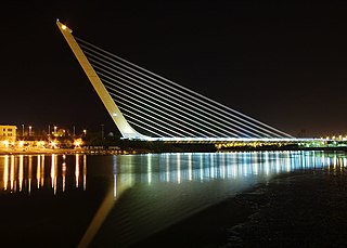
The Alamillo Bridge is a structure in Seville, Andalucia (Spain), which spans the Canal de Alfonso XIII, allowing access to La Cartuja, a peninsula located between the canal and the Guadalquivir River. The bridge was constructed as part of infrastructure improvements for Expo 92, which was held on large banana farms on the island. Construction of the bridge began in 1989 and was completed in 1992 from a design by Santiago Calatrava.

A cantilever spar cable-stayed bridge is a modern variation of the cable-stayed bridge. This design has been pioneered by the structural engineer Santiago Calatrava in 1992 with the Puente del Alamillo in Seville, Spain. In two of his designs the force distribution does not depend solely upon the cantilever action of the spar (pylon); the angle of the spar away from the bridge and the weight distribution in the spar serve to reduce the overturning forces applied to the footing of the spar. In contrast, in his swinging Puente de la Mujer design (2002), the spar reaches toward the cable supported deck and is counterbalanced by a structural tail. In the Assut de l'Or Bridge (2008), the curved backward pylon is back-stayed to concrete counterweights.
A suspension bridge supports its structural load with cables, ropes, or chains anchored at each end. Cables on the earliest suspension bridges were anchored in the ground; some modern suspension bridges anchor the cables to the ends of the bridge itself. Earliest suspension bridges had no towers or piers but the majority of larger modern suspension bridges have them. All of the 14 longest bridges in the world are suspension bridges.
This is a list of properties and historic districts that are listed on the National Register of Historic Places (NRHP) in Puerto Rico, not to be confused with the Puerto Rico Register of Historic Sites and Zones. There are more than 375 listings in Puerto Rico, with one or more listing in each of Puerto Rico's 78 municipalities.
An orthotropic bridge or orthotropic deck is typically one whose fabricated deck consists of a structural steel deck plate stiffened either longitudinally with ribs or transversely, or in both directions. This allows the fabricated deck both to directly bear vehicular loads and to contribute to the bridge structure's overall load-bearing behaviour. The orthotropic deck may be integral with or supported on a grid of deck framing members, such as transverse floor beams and longitudinal girders. All these various choices for the stiffening elements, e.g., ribs, floor beams and main girders, can be interchanged, resulting in a great variety of orthotropic panels.

An extradosed bridge employs a structure that combines the main elements of both a prestressed box girder bridge and a cable-stayed bridge. The name comes from the word extrados, the exterior or upper curve of an arch, and refers to how the "stay cables" on an extradosed bridge are not considered as such in the design, but are instead treated as external prestressing tendons deviating upward from the deck. In this concept, they remain part of the main bridge superstructure.

The La Plata River is the longest river in Puerto Rico. It is located in the north coast of the island. It flows from south to north, and drains into the Atlantic Ocean about 11 miles (18 km) west of San Juan. The mouth of the river is a resort area with white sandy beaches.

The Indio River is a river of Vega Baja and Morovis in Puerto Rico. Indio River has mogotes on either side. Indio River meets Cibuco River. The river is quick to rise and causes flooding when there is heavy rain.

Puerto Rico Highway 5 (PR-5) is a main highway in the San Juan Metropolitan area which connects the cities of Cataño to Bayamón and is being extended and converted to a tollway to access the municipalities of Naranjito and Comerío. It is a short freeway from south Cataño to the business area in Bayamón. It makes intersections with PR-22, PR-6, PR-2 and PR-199, where it ends at this time. The highway will parallel PR-167 and will contain the new cable-stayed bridge being built between Bayamón and Naranjito. It will probably end in Puerto Rico highway 152 when completed.

Puerto Rico Highway 167 (PR-167) is one of the main highways in the San Juan–Caguas–Guaynabo metropolitan area of Puerto Rico. Highway 167 starts at Puerto Rico Highway 165 in Levittown and goes until Puerto Rico Highway 156 in Comerío.
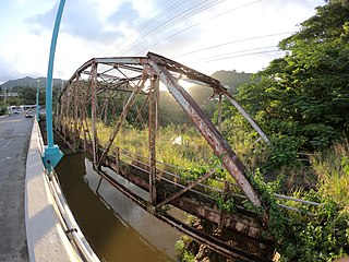
Plata Bridge, listed in Puerto Rico's bridge inventory as Bridge #374 and now also known as Antiguo Puente Plata, was built in 1908. It is significant as "the only extant large multi span truss bridge in Puerto Rico", according to its nomination document for listing on the National Register of Historic Places. It includes two Parker truss spans and was built in 1908. It brought what is now Puerto Rico Highway 167 across the Rio La Plata, spanning from Bayamon municipality and into Naranjito, and connected several mountain towns to the coastal road along Puerto Rico's north coast.

The Arenas Bridge is a truss bridge built in 1894 between the municipalities of Cayey and Cidra in Puerto Rico. Also known as Puente Rio La Plata, it was the longest bridge constructed in Puerto Rico during the Spanish colonial period. It crosses the Rio de la Plata, the longest river in Puerto Rico. According to the U.S. National Park Service, "[t]his is the most important metal bridge in Puerto Rico from the period." The bridge is still standing.

This portion of National Register of Historic Places listings in Puerto Rico is along the central mountain region, from Las Marías and Maricao in the central-west to Juncos in the central-east, including the slopes of the Cordillera.

Porta Cordillera, or simply Central Region, is a land-locked tourism region located in the central mountainous area of Puerto Rico. Porta Cordillera was officially launched in July 2012 by the Puerto Rico Tourism Company. It consists of 16 municipalities: Aguas Buenas, Cidra, Cayey, Comerío, Aibonito, Naranjito, Barranquitas, Corozal, Orocovis, Morovis, Ciales, Jayuya, Florida, Utuado, Adjuntas and Lares.

The Captain William Moore Bridge is an historic 300-foot (91 m) asymmetric single-pylon cable-stayed bridge on the Klondike Highway that spans the Moore Creek Gorge in the borough of Skagway, Alaska, United States, about 17 miles (27 km) north of the city of Skagway. Before the bridge was built in 1976, Whitehorse, Yukon, was only accessible from Skagway by the White Pass and Yukon Route railroad. The bridge connects Skagway to the Yukon highway network and allows traffic to pass over the Moore Creek Gorge, which flows along a fault line. To minimize bridge damage from earthquake movements along the fault line, the bridge was designed with anchors only at one end, which in this case was the south bank. Over the decades, heavy ore truck traffic weakened the bridge. In 2019 a replacement buried bridge located 150 feet west of the historic bridge was opened, and the 1976 cable-stayed bridge was repurposed as a pedestrian viewpoint and wayside historic attraction.
It's historic and beautiful, and is the only cantilevered cable-stayed bridge in Alaska...

The Samuel-De Champlain Bridge, colloquially known as the Champlain Bridge, is a cable-stayed bridge design by architect Poul Ove Jensen and built to replace the original Champlain Bridge over the Saint Lawrence River in Quebec, between Nuns' Island in the borough of Verdun in Montreal and the suburban city of Brossard on the South Shore. A second, connected bridge links Nuns' Island to the main Island of Montreal. It is the busiest bridge in the country with more cars flowing into it than any other bridge.

The Mavilla Bridge, or Bridge 354, is located at kilometer 17.7 on Puerto Rico Highway 159 between Corozal and Bayamón, Puerto Rico. The bridge has maintained most of its original design and structure over the years. It was constructed in 1903 replacing a wooden bridge that had been at the location since 1853, and served as a road between Toa Alta and Bayamón municipalities, in the 19th century.


