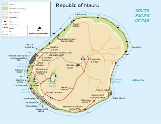
Nauru is a tiny phosphate rock island nation located in the South Pacific Ocean south of the Marshall Islands in Oceania. It is only 53 kilometres (33 mi) south of the Equator at coordinates 0°32′S166°55′E. Nauru is one of the three great phosphate rock islands in the Pacific Ocean—the others are Banaba in Kiribati and Makatea in French Polynesia.

The recorded history of Cape Verde begins with Portuguese discovery in 1456. Possible early references go back around 2000 years.

The Pratas Islands, also known as the Dongsha Islands and Tungsha Islands, are three atolls in the north of the South China Sea. They consist of one island, two coral reefs and two banks, and are located about 170 nautical miles southeast of Hong Kong. The Republic of China (Taiwan) controls them and has declared part of them the Dongsha Atoll National Park. The People's Republic of China claims them as part of China.
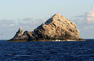
The Gardner Pinnacles are two barren rock outcrops surrounded by a reef and located in the Northwestern Hawaiian Islands at 24°59′56″N167°59′58″W.

Maro Reef is a largely submerged coral atoll located in the Northwestern Hawaiian Islands. It was discovered in 1820 by Captain Joseph Allen of the ship Maro, after whose ship the reef was named. With a total area of 747 square miles (1,935 km2), it is the largest coral reef in the Northwestern Hawaiian Islands. It contains 37 species of stony coral. Unlike most atolls, the coral extends out from the center like spokes on a wheel. Located about 850 miles northwest of Honolulu, Hawaii, Maro Reef contains about 1 acre (4,000 m2) of dry land which itself can be submerged depending on the tides. Some scientists believe that it "may be on the verge of drowning" because the reefs are detached and are vulnerable to strong storm waves.
The Dollabarat Reef is a shoal situated 5 km south-southeast of the Formigas Islets, on the Formigas Bank in the Azores archipelago.

The Pacific Remote Islands Marine National Monument is a group of unorganized, mostly unincorporated United States Pacific Island territories managed by the Fish and Wildlife Service of the United States Department of the Interior and the National Oceanic and Atmospheric Administration of the United States Department of Commerce. These remote refuges are "the most widespread collection of marine- and terrestrial-life protected areas on the planet under a single country's jurisdiction". They protect many endemic species including corals, fish, shellfish, marine mammals, seabirds, water birds, land birds, insects, and vegetation not found elsewhere.

Stellwagen Bank National Marine Sanctuary is an 842-square-mile (638-square-nautical-mile) federally protected marine sanctuary located at the mouth of Massachusetts Bay, between Cape Cod and Cape Ann. It is known as an excellent whale watching site, and is home to many other species of marine life.

Ilhéu de Sal Rei is an uninhabited islet near the coast of Boa Vista Island, Cape Verde. It is located 1 km southwest of the island capital Sal Rei. Its area is 89 ha (0.34 sq mi) and its highest point is 27 m (88.6 ft).

An ocean bank, sometimes referred to as a fishing bank or simply bank, is a part of the seabed which is shallow compared to its surrounding area, such as a shoal or the top of an underwater hill. Somewhat like continental slopes, ocean banks slopes can upwell as tidal and other flows intercept them, resulting sometimes in nutrient rich currents. Because of this, some large banks, such as Dogger Bank and the Grand Banks of Newfoundland, are among the richest fishing grounds in the world.

Morro Negro is a hill located near the east coast of the island of Boa Vista, Cape Verde. Its elevation is 156 m. The nearest village is Cabeça dos Tarrafes, 5.5 km to the northwest.

São Jorge is a settlement in the central part of the island of Santiago, Cape Verde. It is part of the São Lourenço dos Órgãos municipality. In 2010 its population was 6. It is situated 2.5 km southwest of João Teves and 4 km southeast of Picos. Its elevation is 319 meters.
The Princess Alice Bank is a submerged seamount that is located 50 nmi (93 km) to the southwest of the island of Pico and 45 nmi (83 km) to the southwest of the island of Faial in the Portuguese archipelago of the Azores. The western area of the bank has a minimum depth of 35 metres (115 ft), with clear waters that allow the observation of the ocean floor from the surface. With an abundance of biodiversity, the Bank is a fishing area, in addition to being an important diving spot of the Atlantic Ocean.

Nintoku Seamount or Nintoku Guyot is a seamount and guyot in the Hawaiian-Emperor seamount chain. It is a large, irregularly shaped volcano that last erupted 66 million years ago. Three lava flows have been sampled at Nintoku Seamount; the flows are almost all alkalic (subaerial) lava. It is 56.2 million years old.

The Tizard Bank, 10°15′N114°30′E, in Chinese known as 郑和群礁 and Zhenghe Qunjiao, is a partially sunken atoll and one of the significant maritime features of the north-western part of the Spratly Islands. It is claimed by the China, Taiwan and Vietnam, and various parts of it are occupied by these nations.

Farol de Fontes Pereira de Melo is a lighthouse at the northeastern point of the island of Santo Antão in northwestern Cape Verde. It is situated on the headland Ponta de Tumbo, 2 km east of Janela, 6 km southeast of Pombas and 15 km northeast of Porto Novo. The lighthouse was named after Fontes Pereira de Melo, prime minister of Portugal for several times between 1871 and 1886. It is a white octagonal masonry tower, 16 meters high. Its focal height is 162 meters above sea level, and its range is 17 nautical miles. The adjacent building for the lighthouse keeper is abandoned and in poor condition.
The Cadamosto Seamount is a seamount in the North Atlantic Ocean just 20 km southwest of the island of Brava, Cape Verde.
The Cape Verde Rise is an oceanic feature that includes the Cape Verde Islands and the areas north and east of the islands and west of the African Continental Shelf as well as Mauritania and Senegal.
Farol da Preguiça is a lighthouse located near the shore of Baía de São Jorge in Preguiça on the island of São Nicolau in northern Cape Verde. It is a masonry hut, coloured white. It sits at about 18 meters above sea level in the village, it is seven meters tall and its focal height is at 25 meters above sea level. Its focal range is 5 nautical miles. Its characteristic is Fl (2+1) R 15s.
Ponta do Lobo Lighthouse is a lighthouse located near the headland named Ponta do Lobo, in the southeastern part of the island of Santiago, Cape Verde. The lighthouse is located about 4 km east of the nearest village, Vale da Custa, and 11 km northeast of the capital Praia. The lighthouse was built in 1887 and is the island's second oldest. It is a 9 metres high trapezoidal tower, attached to a single storey keeper's house. Its class of light is Fl (4) W 15s., its focal height is at 17 meters above sea level and its range is 10 nautical miles.