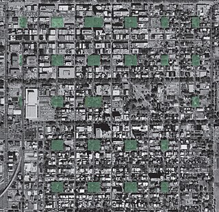
The city of Savannah, Province of Georgia, was laid out in 1733, in what was colonial America, around four open squares, each surrounded by four residential ("tything") blocks and four civic ("trust") blocks. The layout of a square and eight surrounding blocks was known as a "ward." The original plan was part of a larger regional plan that included gardens, farms, and "out-lying villages." Once the four wards were developed in the mid-1730s, two additional wards were laid. Oglethorpe's agrarian balance was abandoned after the Georgia Trustee period. Additional squares were added during the late 18th and 19th centuries, and by 1851 there were 24 squares in the city. In the 20th century, three of the squares were demolished or altered beyond recognition, leaving 21. In 2010, one of the three "lost" squares, Ellis, was reclaimed, bringing the total to today's 22.

The Savannah Historic District is a large urban U.S. historic district that roughly corresponds to the pre-civil war city limits of Savannah, Georgia. The area was declared a National Historic Landmark District in 1966, and is one of the largest urban, community-wide historic preservation districts in the United States. The district was made in recognition of the Oglethorpe Plan, a unique sort of urban planning begun by James Oglethorpe at the city's founding and propagated for the first century of its growth.

The Green–Meldrim House is a historic house at 14 West Macon Street, on the northwest corner of Madison Square, in Savannah, Georgia. Built in 1853, it was designated as a National Historic Landmark in 1976 as one of the American South's finest and most lavish examples of Gothic Revival architecture. The house is owned by the adjacent St. John's Episcopal Church, which offers tours and uses it as a meeting and reception space.
The Savannah Historic District is a large urban U.S. historic district that roughly corresponds to the city limits of Savannah, Georgia, prior to the American Civil War. The area was declared a National Historic Landmark District in 1966, and is one of the largest districts of its kind in the United States. The district was made in recognition of the unique layout of the city, begun by James Oglethorpe at the city's founding and propagated for over a century of its growth.
532–534 East State Street is a historic building in Savannah, Georgia, United States. It is located in the northeastern tything of Greene Square and was built in 1897. It is part of the Savannah Historic District, and it stands immediately to the west of the John Dorsett House, the smallest free-standing house in the city.

538 East State Street is a historic building in Savannah, Georgia, United States. It is located in the northeastern tything of Greene Square and was designated a historic building in 1973. Originally built for a William Ricker in 1818, it was later sold to an Abraham Ricker in 1821. Then in 1861 it was held by Joseph Burke, a cotton merchant and co-founder of the Bank of Commerce, until 1868. It is part of the Savannah Historic District, and it stands immediately to the east of the John Dorsett House, the smallest free-standing house in the city.

Greene Square is one of the 22 squares of Savannah, Georgia, United States. It is the easternmost square in the second row of the city's five rows of squares. The square is located on Houston Street and East President Street, and is south of Washington Square, east of Columbia Square and north of Crawford Square. The oldest buildings on the square are at 510 East York Street, 509 East President Street and 503 East President Street, each in the southwestern trust/civic block, which are believed to have been built at the same time as the square itself (1799).

Johnson Square is one of the 22 squares of Savannah, Georgia, United States. Located in the northernmost row of the city's five rows of squares, it was the first of the squares to be laid out, in 1733, and remains the largest of the 22. It is east of Ellis Square, west of Reynolds Square and north of Wright Square. Situated on Bull Street and St. Julian Street, it is named for Robert Johnson, colonial governor of South Carolina and a friend of General James Oglethorpe. The oldest building on the square is the Ann Hamilton House, at 26 East Bryan Street, which dates to 1824.

Abercorn Street is a prominent street in Savannah, Georgia, United States. Located between Drayton Street to the west and Lincoln Street to the east, it runs for about 7.8 miles (12.6 km) from East Bay Street in the north to Harry S. Truman Parkway in the south. It is concurrent with SR 204 from 37th Street south. The street is named for James Hamilton, 6th Earl of Abercorn, a financial benefactor of the Georgia colony. Its northern section passes through the Savannah Historic District, a National Historic Landmark District.

Drayton Street is a prominent street in Savannah, Georgia, United States. Located between Bull Street to the west and Abercorn Street to the east, it runs for about 2 miles (3.2 km) from East Bay Street in the north to East Victory Drive in the south. It is named for Ann Drayton, a member of a noted family in Charleston, South Carolina, who had lent four sawyers to assist colonists in building one of the first homes in Savannah. The street is one-way (northbound). Its northern section passes through the Savannah Historic District, a National Historic Landmark District.

Lincoln Street is a prominent street in Savannah, Georgia, United States. Located between Abercorn Street to the west and Habersham Street to the east, it runs for about 2 miles (3.2 km) from East Bay Street in the north to East Victory Drive in the south. It is named for Benjamin Lincoln, a Revolutionary War hero. The street is one-way (northbound) south of Colonial Park Cemetery, which interrupts it between East Oglethorpe Avenue and East Perry Lane. The Lincoln Street Ramp leads down through Factors Walk to River Street and the Savannah River waterfront. Its northern section passes through the Savannah Historic District, a National Historic Landmark District.
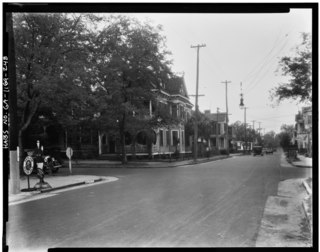
Price Street is a prominent street in Savannah, Georgia, United States. Located between Habersham Street to the west and East Broad Street to the east, it runs for about 2.04 miles (3.28 km) from East Bay Street in the north to East Victory Drive in the south. The street's directional flow is one-way (southbound), with a single lane for motor vehicles and a dedicated lane for cyclists. Its northern section passes through the Savannah Historic District, a National Historic Landmark District.

Barnard Street is a prominent street in Savannah, Georgia, United States. Located between Jefferson Street to the west and Whitaker Street to the east, it runs for about 2.54 miles (4.09 km) from West Bay Street in the north to West 52nd Street in the south. The street is named for Sir John Barnard, Lord Mayor of London in 1737 and 1740. Its northern section passes through the Savannah Historic District, a National Historic Landmark District.

Whitaker Street is a prominent street in Savannah, Georgia, United States. Located between Barnard Street to the west and Bull Street to the east, it runs for about 2.07 miles (3.33 km) from West Bay Street in the north to West Victory Drive in the south. Its directional flow is one-way (southbound). The street is named for Benjamin Whitaker, surveyor general of South Carolina.

Broughton Street is a prominent street in Savannah, Georgia, United States. Located between Congress Street to the north and State Street to the south, it runs for about 0.75 miles (1.21 km) from Martin Luther King Jr. Boulevard in the west to East Broad Street in the east. Originally known only as Broughton Street singular, its addresses are now split between "West Broughton Street" and "East Broughton Street", the transition occurring at Bull Street in the center of the downtown area. Broughton Street is named for Thomas Broughton, lieutenant-governor of South Carolina.
Liberty Street is a prominent street in Savannah, Georgia, United States. Located between Perry Street to the north and Harris Street to the south, it runs for about 0.90 miles (1.45 km) from Martin Luther King Jr. Boulevard in the west to Randolph Street in the east. Originally known only as Liberty Street singular, its addresses are now split between "West Liberty Street" and "East Liberty Street", the transition occurring at Bull Street in the center of the downtown area. The street is entirely within Savannah Historic District, a National Historic Landmark District.
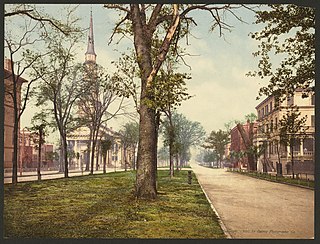
Oglethorpe Avenue is a prominent street in Savannah, Georgia, United States. Located, in its downtown section, between York Street to the north and Hull Street to the south, it runs for about 1.26 miles (2.03 km) from the Atlantic Coastal Highway in the west to Randolph Street in the east. It was originally known as South Broad Street, then Market Street. After being named South Broad Street again for a period, it became known as Oglethorpe Avenue in 1897. It was formerly Oglethorpe Avenue singular, but its addresses are now split between "West Oglethorpe Avenue" and "East Oglethorpe Avenue", the transition occurring at Bull Street in the center of the downtown area. The street is named for the founder of the Savannah colony, James Edward Oglethorpe.

State Street is a prominent street in Savannah, Georgia, United States. Located between Broughton Street to the north and York Street to the south, it runs for about 0.70 miles (1.13 km) from Montgomery Street in the west to East Broad Street in the east.

York Street is a prominent street in Savannah, Georgia, United States. Located, in its downtown section, between State Street to the north and Oglethorpe Avenue to the south, it runs for about 0.70 miles (1.13 km) from Montgomery Street in the west to East Broad Street in the east. It is named for the Duke of York. The street is entirely within Savannah Historic District, a National Historic Landmark District.
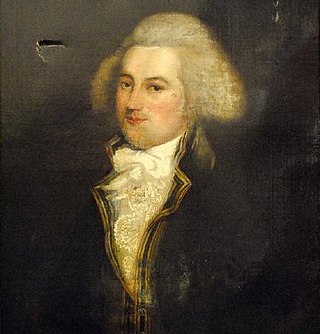
Houston Street is a prominent street in Savannah, Georgia, United States. Located between Price Street to the west and East Broad Street to the east, it runs for about 0.44 miles (0.71 km) from East Bay Street in the north to East Liberty Street in the south. The street is named for prominent Georgian William Houstoun, whose portrait hangs in the rotunda of Savannah City Hall. It passes through the Savannah Historic District, a National Historic Landmark District.

