The Green River Formation is an Eocene geologic formation that records the sedimentation in a group of intermountain lakes in three basins along the present-day Green River in Colorado, Wyoming, and Utah. The sediments are deposited in very fine layers, a dark layer during the growing season and a light-hue inorganic layer in the dry season. Each pair of layers is called a varve and represents one year. The sediments of the Green River Formation present a continuous record of six million years. The mean thickness of a varve here is 0.18 mm, with a minimum thickness of 0.014 mm and maximum of 9.8 mm.

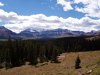
The Uinta Mountains are an east-west trending chain of mountains in northeastern Utah extending slightly into southern Wyoming in the United States. As a subrange of the Rocky Mountains, they are unusual for being the highest range in the contiguous United States running east to west, and lie approximately 100 miles (160 km) east of Salt Lake City. The range has peaks ranging from 11,000–13,528 feet (3,353–4,123 m), with the highest point being Kings Peak, also the highest point in Utah. The Mirror Lake Highway crosses the western half of the Uintas on its way to Wyoming.

Kings Peak is the highest peak in the U.S. state of Utah, with an elevation of 13,534 feet (4,125 m) NAVD 88.

Fremont River is 95-mile (153 km) long river in southeastern Utah, United States that flows from the Johnson Valley Reservoir, which is located on the Wasatch Plateau near Fish Lake, southeast through Capitol Reef National Park to the Muddy Creek near Hanksville where the two rivers combine to form the Dirty Devil River, a tributary of the Colorado River.

The Provo River is located in Utah County and Wasatch County, Utah, in the United States. It rises in the Uinta Mountains at Wall Lake and flows about 71 miles (114 km) southwest to Utah Lake at the city of Provo, Utah.

The Uinta Basin is a physiographic section of the larger Colorado Plateaus province, which in turn is part of the larger Intermontane Plateaus physiographic division. It is also a geologic structural basin in eastern Utah, east of the Wasatch Mountains and south of the Uinta Mountains. The Uinta Basin is fed by creeks and rivers flowing south from the Uinta Mountains. Many of the principal rivers flow into the Duchesne River which feeds the Green River—a tributary of the Colorado River. The Uinta Mountains forms the northern border of the Uinta Basin. They contain the highest point in Utah, Kings Peak, with a summit 13,528 feet above sea level. The climate of the Uinta Basin is semi-arid, with occasionally severe winter cold.

Mount Agassiz is a peak in the Uinta Mountains of northeastern Utah with an elevation of 12,433 feet (3,790 m). It is located in the High Uintas Wilderness and the Uinta-Wasatch-Cache National Forest. The summit is named in honor of Louis Agassiz, a well-known paleontologist, glaciologist and geologist.

Blacks Fork is a 175-mile-long (282 km) tributary of the Green River in Utah and Wyoming. The river rises on the northern side of the Uinta Mountains as the combination of three streams draining the area around Tokewanna Peak near the Utah–Wyoming border. Right as the river crosses the Wyoming border, it flows into Meeks Cabin Reservoir which is used for irrigation and flood control. From there the river flows through the town of Lyman before joining with the Smiths Fork, which forms just east of the Blacks Fork in the Uintas, and parallels it for most of its course. The river continues northeast to Granger, where the river meets the Hams Fork from the north. Shortly thereafter the river makes a sharp turn south, eventually joining the Green River at Flaming Gorge Reservoir.

Altonah is an unincorporated community in central Duchesne County, Utah, United States.

Lapoint is an unincorporated community in western Uintah County, Utah, United States.

Mountain Home is an unincorporated community in central Duchesne County, Utah, United States, adjacent to the Uintah and Ouray Indian Reservation.

The High Uintas Wilderness is a wilderness area located in northeastern Utah, United States. The wilderness covers the Uinta Mountains, encompassing parts of Duchesne and Summit counties. Designated as a wilderness in 1984, the area is located within parts of Ashley National Forest and Uinta-Wasatch-Cache National Forest, managed by the U.S. Forest Service. The highest peak in Utah, Kings Peak, lies within the wilderness area along with some of Utah's highest peaks, particularly those over 13,000 feet.

Moon Lake is a high mountain reservoir on the south slope of the High Uintas in Duchesne County, Utah. Recreation management is under the jurisdiction of the U.S. Forest Service, as the lake is part of the Ashley National Forest.

Crescent Lake is a lake in northeastern Cache County, Utah, United States.
Crouse Creek is a stream in the Uinta Mountains near the eastern edge of Daggett County, Utah, United States.

Cutthroat Lake is a lake in the Uinta Mountains in south‑central Summit County, Utah, United States.
Davis Lakes is a group of lakes near the northern edge of Duchesne County, Utah, United States.

Dead Lake is a lake in the Uinta Mountains in the northwestern corner of Uintah County, Utah, United States.

Dean Lake is a lake in the northwestern corner of Duchesne County, Utah, United States.
Currant Creek may refer to:


