
Doda district is an administrative district of the Jammu division of Indian-administered Jammu and Kashmir in the disputed Kashmir region.
Gandoh is a tehsil in district Doda of the Indian union territory of Jammu and Kashmir. The village is located on Thathri-Gandoh National Highway.

Thathri is a town and a notified area committee in Doda district in the Indian union territory of Jammu and Kashmir. Thathri valley is located in the foothills of the Himalayan mountains, about 85 km from Batote. Apart from having ample forests, the town contains many small streams flowing through its various parts. It is located on the banks of the Chenab River and the town area is spread over 1.50 sq. Km².

Jantroon Dhar or Jantroon Top is a location in the Doda district, in Jammu and Kashmir, India. It is a local hill station and a meadow in the Forest Block area, 15 kilometers away from Thathri. The place is surrounded by lush green meadows, snow in winters and covered with dense vegetation. Thousands of local tourists visit every year for spectating three days dangal-cum-wrestling match.
Chiralla is an Indian village and a tehsil in Doda district of Jammu and Kashmir. It was formerly part of Thathri tehsil and block. This tehsil have 9 Panchayats including Bhallara, Chagsoo, Jagota, Chiralla, Panshei, Puneja, Rokali, Sunarthawa and Thallela.
Ababeel (ابابیل), also known as Ababeel NGO, is a charitable trust that provides emergency assistance, disaster relief, food kits, and blood donations for the needy, poor, orphans, widows, and also in emergencies in the Chenab Valley's Doda, Kishtwar, Thathri, Bhaderwah, Gandoh, and also in the Jammu area. The organization assists people irrespective of caste and religion. It is registered with the Sub Registrar Court Doda.
Zea Abad, is a village in Thathri sub division of Doda district. It is the part of panchayat Jangalwar located on the Batote-Kishtwar National Highway.

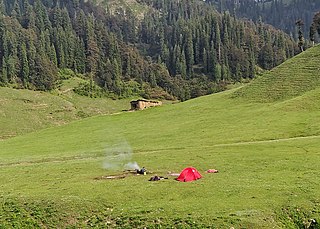
Jai Valley is an enchanting valley located 32 kilometres (20 mi) northeast of Bhaderwah town in Jammu and Kashmir, India. The Bhaderwah-Jai road, which passes through the corniferous deodar forests of Nakshri, Balote, Bhalara and Chinta Valley connects the valley with the Bhaderwah town. The valley has green meadows which act as the attraction for tourists in summers and the snow-covered landscape during winters. Jai valley has about 9 kilometres (5.6 mi) long meadows, bisected by a stream called Jai Nallah which merges with a tributary of river Chenab at Kahara in tehsil Thathri. It is also known by the names Jai Garh and Jai Top. The valley is also connected through a 37 kilometres (23 mi) long road with Gandoh. There is no Mobile Network in this valley.
Chinta Valley is a valley and a village located 20 kilometres (12 mi) northeast of Bhaderwah town on Bhaderwah-Jai road. It is covered with thick coniferous forests from all sides with a stream flowing through it known as Chinta Nallah. A village called Thuba divides the valley from Bhaderwah.
Bhal Padri is a hill station situated above a group of small valleys covered with a dense forest located in the Changa, Bhalessa. area of Doda district. It borders Padri Pass, Bhaderwah at a distance of 4 kilometres (2.5 mi) northeast. Rivulets and streams flow through this valley.

Kahara is a village and tehsil in Doda district, Jammu, India. It is situated between mountainous cliffs 13 kilometres (8.1 mi) from Thathri on the Thathri-Gandoh road.
Donadi is a village in Kahara tehsil of Doda district in the Indian union territory of Jammu and Kashmir. It is famous for a hydroelectric power project called Lower Kalnie Power Project Donadi.
Chilly Pingal or Chilly Pingle is a tehsil of Doda district in the union territory of Jammu and Kashmir. The Headquarter of the Tehsil is Located at Tandla village.
Bunjwah is a region and tehsil located in the Kishtwar district of Jammu and Kashmir, India. It comprises nine panchayat and two nayabats; it became a tehsil in 2014.
Badanoo is a village in Thathri tehsil of Doda district in Jammu and Kashmir. It is located at least 36 kilometres from its district headquarters. This village is the part of Patwar Halqa Jangalwar.
Jangalwar is a village and panchayat in the Thathri tehsil of Doda district in the Jammu division of Jammu and Kashmir, India.
Shibnote is a village in Thathri sub-division of Doda district in Jammu and Kashmir.
Nandana or Nandna is a village and panchayat in Thathri of Doda district in the union territory of Jammu and Kashmir. Nandana is located in the hilly area of Doda district and have deep gorges.
Thathri–Gandoh National Highway is a 30-kilometre (19 mi) road that connects Thathri to Gandoh, located in the Doda district of Jammu and Kashmir, India. The road serves as a lifeline for the people living in the Bhalessa region as it provides access to various link roads leading to rural and far-flung areas. In 2022, this road was declared a National Highway by Lieutenant Governor of Jammu and Kashmir Manoj Sinha.
Halaran is a village and panchayat located in the Kahara tehsil of Doda district in the Indian administered union territory of Jammu and Kashmir. The village is situated approximately 13 kilometers away from the sub-divisional headquarters, Thathri, and 43 kilometers away from the district headquarters, Doda.
