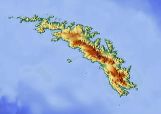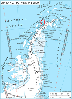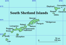
The Bay of Isles is a bay 9 miles (14 km) wide and receding 3 miles (5 km), lying between Cape Buller and Cape Wilson along the north coast of South Georgia. It was discovered in 1775 by a British expedition under James Cook and so named by him because numerous islands lie in the bay. Many of these islands are named after local birds, including:

Crean Glacier is a glacier 4 miles (6.4 km) long, flowing northwest from Wilckens Peaks to the head of Antarctic Bay on the north coast of South Georgia. It was surveyed by the South Georgia Survey in the period 1951–57 and named by the UK Antarctic Place-Names Committee for Irishman Tom Crean, Second Officer of the Endurance during the British expedition under Ernest Shackleton, 1914–16. Crean accompanied Shackleton and Frank Worsley in the James Caird from Elephant Island to King Haakon Bay, South Georgia, and made the overland crossing with them to Stromness; this glacier lies on the route.

Proud Island is a small, relatively high, tussock-covered island, rising to a peak at its northern end, lying at the east end of the Willis Islands at South Georgia. It was roughly mapped by Discovery Investigations personnel in 1960-61. The name was given in 1963 by the United Kingdom Antarctic Place-Names Committee (UK-APC) and is descriptive, the expression "standing proud" in naval parlance being the equivalent of "sticking up."
Inner Lee Island is a small island 1.3 km (0.8 mi) north-northeast of Luck Point, lying in the Bay of Isles, South Georgia. This island was charted in 1912–13 by Robert Cushman Murphy, an American naturalist abroad the brig Daisy, who included it as one of two islands which called the "Lee Islands". These islands were recharted in 1929–30 by Discovery Investigations personnel, who renamed this southwestern of the two, Inner Lee Island. The northeastern island is now known as Outer Lee Island.

Endurance Glacier is a broad glacier north of Mount Elder, draining south-east to the south coast of Elephant Island in the South Shetland Islands of Antarctica, and is the main discharge glacier on the island. It was named by the UK Antarctic Place-Names Committee after HMS Endurance, which anchored off the glacier on several occasions in support of the Joint Services Expedition to Elephant Island, 1970–71.

Andersson Peak is an ice-capped peak, 1,230 metres (4,040 ft) high, with rocky exposures on its east side, lying 9 nautical miles (17 km) north of Cape Fairweather on the east coast of Graham Land, Antarctica. It was charted in 1947 by the Falkland Islands Dependencies Survey, and named by them for Karl Andreas Andersson, a zoologist with the Swedish Antarctic Expedition, who had explored along this coast in 1902.

Anna Glacier is a glacier flowing southeast between Rose Peak and Rea Peak, tributary to Polonia Glacier/Polonia Ice Piedmont at the head of King George Bay, King George Island. It was named by the Polish Antarctic Expedition (PAE), 1981, after Anna Tokarska, field assistant of PAE geological party to King George Island, 1979–80, and wife of Antoni K. Tokarski.

The Brugmann Mountains, rising to 850 metres (2,800 ft), are steep and rugged on the east slopes but are icecapped and descend gently toward the west, extending in a northeast–southwest arc along the east side of Liège Island, in the Palmer Archipelago. Their principal peaks are Mount Vesalius, Pavlov Peak, Mishev Peak, Mount Kozyak, Vazharov Peak and Balkanov Peak.
Mount Clara is a peak rising to about 790 metres (2,600 ft) to the east of Mount Normann and south of Larsen Harbour, in southeast South Georgia. It was charted and named by Discovery Investigations personnel in 1927.

Sultan Glacier is a glacier flowing south-west into Table Bay, Elephant Island, in the South Shetland Islands of Antarctica. It was named by the United Kingdom Antarctic Place-Names Committee (UK-APC) after HMS Sultan, a shore-based Royal Navy engineering school which provided the refuge hut for the UK Joint Services Expedition to Elephant Island, 1970-71.
Murrish Glacier is a glacier about 15 nautical miles (28 km) long on the east side of Palmer Land. It drains east-northeast, to the north of Stockton Peak and Abendroth Peak, and merges with the north side of Gain Glacier before the latter enters the Weddell Sea opposite Morency Island. It was named by the Advisory Committee on Antarctic Names (US-ACAN) for David E. Murrish, United States Antarctic Research Program (USARP) biologist and party leader for the study of peripheral vascular control mechanisms in birds in the Antarctic Peninsula region for three seasons, 1972-75.
Diamonen Island is an island lying north of Moreno Rock in Gerlache Strait, off the west coast of Graham Land. It was charted by the Belgian Antarctic Expedition under Gerlache, 1897–99. The island was called "Big Diamonen Island" by Captain Skidsmo of the Graham in 1921–22. The name was shortened by the UK Antarctic Place-Names Committee in 1960.
Dietz Bluff is a prominent bluff at the head of Hilton Inlet on the Black Coast, Palmer Land. The bluff was photographed from the air by the United States Antarctic Service, 1940, and by the Ronne Antarctic Research Expedition, 1947. It was mapped by the United States Geological Survey from U.S. Navy aerial photographs taken 1966–69, and named by the Advisory Committee on Antarctic Names, in association with the names of continental drift scientists grouped in this area, after Robert S. Dietz, an American marine geologist with the Atlantic Oceanographic and Meteorological Laboratory, Miami, Florida, from 1967.
Dimaryp Peak is the prominent northeastern peak of Mount Carroll, rising to 500 metres (1,600 ft), 1 nautical mile (2 km) south of the head of Hope Bay, Trinity Peninsula. First charted by the Swedish Antarctic Expedition under Otto Nordenskiöld, 1901–04, it was surveyed in 1945 and 1955 by the Falkland Islands Dependencies Survey, who applied the name. This peak is very similar to and has been frequently misidentified in bad weather as The Pyramid, a peak 0.8 nautical miles (1.5 km) to the east. The name is simply the word "pyramid" reversed.
False Round Point is a point 16 km (9.9 mi) west of North Foreland and 4 km (2.5 mi) south of Ridley Island, on the north coast of King George Island in the South Shetland Islands of Antarctica. The point has appeared on charts since about 1822. It was probably named for its similarity to Round Point, which lies 22 km (14 mi) to the west, by Discovery Investigations personnel on the Discovery II who charted the north coast of this island in 1937.
Havfruen Peak is a peak in the eastern part of Bristol Island, South Sandwich Islands. It is 365 metres (1,200 ft) high and is conspicuous from both north and south. It was named by the UK Antarctic Place-Names Committee in 1971 after the Norwegian barque Havfruen which was damaged by ice and sank off the South Sandwich Islands on December 1, 1911.

Highton Glacier is a glacier on the east coast of Clarence Island in the South Shetland Islands, south of Sugarloaf Island, flowing northeast to the sea. Called "Stamina Glacier" from the stamina needed to cross it by the Joint Services Expedition to the Elephant Island Group, 1976–77, it was named by the UK Antarctic Place-Names Committee in 1980 after Commander John E. Highton, Royal Navy, Deputy Leader of the expedition and in charge of the group on Clarence Island.
Hesse Peak is, at 515 metres (1,690 ft), the highest peak on Paryadin Ridge, lying midway between Cape Alexandra and Cape Paryadin at the west end of South Georgia. It was charted and named by a German expedition under Kohl-Larsen in 1928–29.
Humble Point is a low point 5 nautical miles (9 km) southwest of Cape Lloyd on the west coast of Clarence Island in the South Shetland Islands. The feature is called "Punta Baja" on Argentine government charts of the 1950s, but that descriptive name is repetitive. The UK Antarctic Place-Names Committee recommended translation of "Punta Baja" to Humble Point in 1971, and that form has been approved to avoid duplication.
Hunt Peak is a triangular rock peak, 610 metres (2,000 ft) high, marking the north side of the entrance to Stonehouse Bay on the east coast of Adelaide Island, Antarctica. It was discovered and first roughly surveyed in 1909 by the French Antarctic Expedition under Jean-Baptiste Charcot. It was resurveyed in 1948 by the Falkland Islands Dependencies Survey (FIDS), who named the point marked by this peak for Sergeant Kenneth D. Hunt, a mechanic for the expedition's Noorduyn Norseman airplane in 1950. Further survey in 1957–58 by the FIDS showed no definable point in the vicinity and the name was transferred to the peak.


