
Zwolle is a city and municipality in the Northeastern Netherlands. It is the capital of the province of Overijssel and the province's second-largest municipality, after Enschede, and has a population of 132.441 as of December 2023. Zwolle borders the province of Gelderland and lies on the eastern side of the River IJssel.
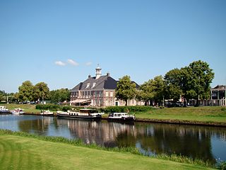
Ommen is a municipality and a Hanseatic city in the eastern Netherlands. It is located in the Vecht valley of the Salland region in Overijssel. Historical records first name Ommen in the early 12th century and it was officially founded as a city in 1248. The municipality had a population of 18,295 in 2021 and covers an area of 182.01 km2 (70.27 sq mi).

Weesp is a city, an urban area in the municipality of Amsterdam in the province of North Holland, Netherlands. It had a population of 20,445 in 2021. It lies on the river Vecht and next to the Amsterdam–Rhine Canal in an area called the Vechtstreek. The former municipality of Weesp merged with Amsterdam on 24 March 2022.

Wappinger is a town in Dutchess County, New York, United States. The town is located in the Hudson River Valley region, on the eastern bank of the Hudson River. The population was 28,216 at the 2020 census. The name is derived from the Wappinger Native Americans who inhabited the area. Wappinger comprises three-fourths of the incorporated village of Wappingers Falls, several unincorporated hamlets such as Chelsea, Diddell, Hughsonville, Middlebush, Myers Corners, New Hackensack, and Swartwoutville, and a number of neighborhoods.

Woluwe-Saint-Pierre or Sint-Pieters-Woluwe is one of the 19 municipalities of the Brussels-Capital Region, Belgium. Located in the eastern part of the region, it is bordered by Etterbeek, Auderghem and Woluwe-Saint-Lambert, as well as the Flemish municipalities of Kraainem and Tervuren. In common with all of Brussels' municipalities, it is legally bilingual (French–Dutch).

Waregem, sometimes known as Waereghem, is a municipality and city located in the Belgian province of West Flanders. The municipality lies in the valley of the river Leie, between Kortrijk and Ghent. It is part of the arrondissement of Kortrijk and comprises the towns of Beveren, Desselgem, Sint-Eloois-Vijve and Waregem proper. On January 1, 2019, Waregem had a total population of 38,260. The total area is 44.34 km² which gives a population density of 863 inhabitants per km².
Tegelen is a village in the municipality of Venlo, situated in the Netherlands. It was an independent municipality until 2001, when it was merged into the municipality of Venlo.

Salland is a historical dominion in the west and north of the present Dutch province of Overijssel. Nowadays Salland is usually used to indicate a region corresponding to the part of the former dominion more or less to the west of Twente.
Oud-Zuilen is a village in the Dutch province of Utrecht. It is a part of the municipality of Stichtse Vecht, and lies about 4 km northwest of Utrecht. It is in an area called the "Vechtstreek". Zuylen Castle is located in the village.

Nieuwer-Ter-Aa is a village in the Dutch province of Utrecht (province). It is a part of the municipality of Stichtse Vecht, and lies about 13 km northwest of Utrecht.

Oud-Aa is a hamlet in the Dutch province of Utrecht (province). It is a part of the municipality of Stichtse Vecht, and lies about 13 km northeast of Woerden.
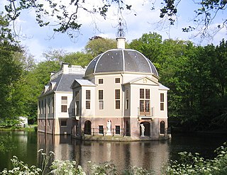
A buitenplaats was a summer residence for rich townspeople in the Netherlands. During the Dutch Golden Age of the 17th century, many traders and city administrators in Dutch towns became very wealthy. Many of them bought country estates, at first mainly to collect rents, however soon mansions started to be built there, which were used only during the summer.

Nieuwleusen is a town in the Dutch province of Overijssel with 9300 inhabitants as of 2021. In the 2001 municipal reform, most of the former municipality of Nieuwleusen was incorporated into the municipality of Dalfsen. Some parts of the former municipality, including the Lichtmis area, was added to the neighbouring municipality of Zwolle.
Oost-Maarland is a village in the south east of the European country Netherlands. There it is an administrative population centre in the Eijsden-Margraten municipality, which forms part of the province of Limburg. In fact Oost-Maarland consists of two separate places with a different history. One is the village and former municipality of Oost, whereas the other is an in a distance of a few hundred metres separately to the southeast situated township called Maarland.
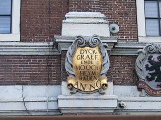
In the Netherlands, a water board, water council or water authority is a regional governing body solely charged with the management of surface water in the environment. Water boards are independent of administrative governing bodies like provinces and municipalities. In general, they are responsible for managing rivers and canals, issues with the flow of watercourses and drainage issues, water collection, flood and erosion prevention and provision of potable water. They manage polder systems, water levels, water barriers and locks, enforcements, water quality and sewage treatment in their respective regions. The concept of a coordinating "High Water Authority" (Hoogheemraadschap) originated in what now is the province of South Holland in the 12th century.
Heers is a hamlet in the south of the municipality of Veldhoven in the province of North Brabant, the Netherlands. Most of the buildings are concentrated around a town square with trees. At this town square is a chapel from 1990 located. There is also a monument, erected in 1966 for the local agricultural consolidation project. Heers has a long history. The hamlet is mentioned in books from the Middle Ages. Also, archaeological artefacts from the Bronze Age and the Roman Empire have been unearthed near the hamlet.

Halfmijl is a hamlet in the west of the municipality of Veldhoven in the province of North Brabant, the Netherlands. The hamlet is located two kilometers east of the village Vessem and consists of eight houses, most of which are farms.
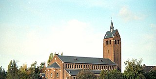
Den Hulst, spelled at times De Hulst and traditionally pronounced Nulst locally is a historical Dutch hamlet which was incorporated into the village and municipality of Nieuwleusen. The northern part of Nieuwleusen is known as Den Hulst to this day.

Imstenrade is a hamlet in the southeastern Netherlands. It is part of the municipality of Heerlen in the province of Limburg, about 20 km east of Maastricht. The village lies between Benzenrade and Simpelveld, next to the A76 motorway and the N281 provincial road. In 2014 the village had a population of 336 and was home to an immigration detention centre with space for 700 immigrants.

Johannes Jacobus "Jan" Klink is a Dutch civil servant and politician for the conservative liberal People's Party for Freedom and Democracy (VVD). Born in the province of Groningen, he co-owned a dairy farm and worked at the Ministry of Economic Affairs, Agriculture and Innovation. He was elected to the Wijdemeren municipal council in 2018 and became an alderman shortly after. Klink was appointed to the House of Representatives in June 2021.


