
Sibuyan is a crescent-shaped island, the second largest in an archipelago comprising Romblon Province, Philippines. Located in the namesake Sibuyan Sea, it has an area of 445 square kilometres (172 sq mi) and has a total population of 62,815, as of the 2020 census. The island has two prominent peaks, the highest is Mount Guiting-Guiting, with an elevation of 2,058 metres (6,752 ft), followed by Mount Nailog, which is 789 metres (2,589 ft) high. The people speak the Sibuyanon dialect of Romblomanon, a Visayan language.

The Ethiopian Highlands is a rugged mass of mountains in Ethiopia in Northeast Africa. It forms the largest continuous area of its elevation in the continent, with little of its surface falling below 1,500 m (4,900 ft), while the summits reach heights of up to 4,550 m (14,930 ft). It is sometimes called the "Roof of Africa" due to its height and large area. It is the only country in the region with such a high elevated surface. This elevated surface is bisected diagonally by the Great East African Rift System which extends from Syria to Mozambique across the East African Lakes. Most of the Ethiopian Highlands are part of central and northern Ethiopia, and its northernmost portion reaches into Eritrea.

Mount Nimba Strict Nature Reserve is a protected area and UNESCO World Heritage Site located in both Guinea and Côte d'Ivoire, extending over a total of area of 175.4 km2, with 125.4 km2 in Guinea, and 50 km2 in Côte d'Ivoire. The reserve covers significant portions of the Nimba Range, a geographically unique area with unusually rich flora and fauna, including exceptional numbers of single-site endemic species, such as Nimbaphrynoides, the Nimba otter shrew, and multiple species of horseshoe bats. Its highest peak is Mount Richard-Molard at 1,752 m (5,750 ft), which is the highest peak of both countries.
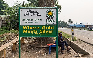
Mgahinga Gorilla National Park is a national park in southwestern Uganda. It was created in 1991 and covers an area of 33.9 km2 (13.1 sq mi).

The Cameroonian Highlands forests, also known as the Cameroon Highlands forests, is a montane tropical moist broadleaf forest ecoregion located on the range of mountains that runs inland from the Gulf of Guinea and forms the border between Cameroon and Nigeria. This is an area of forest and grassland which has become more populous as land is cleared for agriculture.
The Namuli apalis is a small African passerine bird belonging to the genus Apalis in the family Cisticolidae. It was formerly considered as a subspecies of the bar-throated apalis.

The wildlife of Cameroon is composed of its flora and fauna. Bordering Nigeria, it is considered one of the wettest parts of Africa and records Africa's second highest concentration of biodiversity. To preserve its wildlife, Cameroon has more than 20 protected reserves comprising national parks, zoos, forest reserves and sanctuaries. The protected areas were first created in the northern region under the colonial administration in 1932; the first two reserves established were Mozogo Gokoro Reserve and the Bénoué Reserve, which was followed by the Waza Reserve on 24 March 1934. The coverage of reserves was initially about 4 percent of the country's area, rising to 12 percent; the administration proposes to cover 30 percent of the land area.

Mulanje Mountain Forest Reserve is a nature reserve founded in 1927 in Malawi. The reserve covers 56,317 hectares. It is operated by the Mulanje Mountain Conservation Trust. The reserve was designated a biosphere reserve by UNESCO in 2000.

The Chirinda apalis is a species of passerine bird belonging to the family Cisticolidae. This species is endemic to the Eastern Highlands of Zimbabwe and Mozambique. Its natural habitats are subtropical or tropical moist lowland forest and subtropical or tropical moist montane forest.
The Kabobo apalis is a species of bird in the family Cisticolidae. It is endemic to the Kabobo Massif in eastern Democratic Republic of the Congo. Its natural habitat is tropical moist montane forests.
The long-billed forest warbler, also known as the long-billed tailorbird, is a songbird of the family Cisticolidae, formerly part of the "Old World warbler" assemblage. It is found in Tanzania and Mozambique. Its natural habitat is subtropical or tropical moist montane forests. It is threatened by habitat destruction.

The chestnut-throated apalis is a species of bird in the cisticola family Cisticolidae. The Kabobo apalis, originally described as a distinct species, is usually treated as a subspecies A. p. kaboboensis of the chestnut-throated apalis today. It is itself sometimes considered to be the same species as the Chapin's apalis.
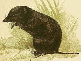
Myosorex is a mammal genus in the Soricidae (shrew) family. The genus, collectively referred to as the mouse shrews, contains these species:

Mount Namuli is the second highest mountain in Mozambique and the highest in the Province of Zambezia. It is 2,419 m (7,936 ft) high and was measured, surveyed and described in 1886 by Henry Edward O'Neill, the British consul in Mozambique. The Namuli massif consists of a level plateau with the granite dome of Mount Namuli above. The area was historically clad in tropical rainforest and is an important biodiversity hotspot with many endemic species of animals and plants. The lower slopes are now mainly used for the cultivation of tea and the middle slopes for other agricultural purposes, with indigenous forest now mostly restricted to the higher parts and corridors along water courses.

The Southern Zanzibar–Inhambane coastal forest mosaic, also known as the Southern Swahili coastal forests and woodlands, is a tropical moist broadleaf forest ecoregion of eastern Africa. It is a southern variation of Northern Zanzibar-Inhambane coastal forest mosaic. The ecoregion supports habitats of forest, savanna and swamps. The southern portion of the ecoregion is not as well studied due to the 1977-1992 civil war in Mozambique.
The Itombwe Mountains are a range of mountains in the South Kivu province of the Democratic Republic of the Congo (DRC). They run along the west shore of the northern part of Lake Tanganyika. They contain a vast area of contiguous montane forest and are home to a rich diversity of wildlife.

The Gran Caldera de Luba Scientific Reserve is a protected area of 51,000 hectares on the volcanic island of Bioko, a part of Equatorial Guinea. The dense rainforest is rich in plant and animal species including a high population of primates, some endemic to the reserve. Much of the reserve consists of pristine forest. However, the primate population is under threat due to growing demand for bushmeat coupled with lack of enforcement of the ban on hunting in the reserve.
Alexandre Romanovich Prigogine was a Belgian mineralogist and ornithologist of Russian-Jewish origin.

Mount Gorongosa is an inselberg in Sofala Province of central Mozambique. Its highest peak, Gogogo, reaches an elevation of 1,863 meters. It was created by Karoo Volcanism.
Hosséré Vokré is an isolated plateau in the North Region of Cameroon. It covers approximately 930 square kilometres (360 sq mi), and forms a broad u-shaped ridge that opens northwards toward the town of Poli. Its highest point is 2,049 metres (6,722 ft). ‘Hosséré' is a regional term for isolated massifs which rise above the savanna lowlands. The Hosséré Godé massif is close by to the northwest. It is separated from other mountains by lowlands less than 500 meters in elevation, including the Alantika Mountains to the northwest along the Nigeria–Cameroon border, and the Adamawa Plateau to the south.
