Nalgonda district is a district in the Telangana state of India. Nalgonda district has the highest number of mandals in the state with 31 mandals. The district shares boundaries with Suryapet, Rangareddy, Yadadri and Nagarkurnool districts and with the state boundary of Andhra Pradesh. In terms of area, Nalgonda is the largest district with an area of 7222.78 km2 in the state.

Nizamabad district is a district located in the north-western region of the Indian state of Telangana. The city of Nizamabad is the district headquarters. The district share boundaries with Jagtial, Sircilla, Nirmal, Kamareddy districts and with Nanded district of the state boundary of Maharashtra.

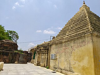
Shamshabad is a city in the Indian state of Telangana. It is located in Shamshabad mandal of Rajendranagar revenue division. Sri Vendikonda Siddalingeshwara Devastanam temple is situated in Siddulagutta Road in Shamshabad mandal. The international airport of Hyderabad is located here.

Bhongir, officially known as, Bhuvanagiri is a City and a district headquarters of the Yadadri Bhuvanagiri district and part of the Hyderabad Metropolitan Region of the Indian state of Telangana.

Jadcherla is a census town in Mahbubnagar district of the Indian state of Telangana. It is located in Jadcherla mandal in Mahbubnagar revenue division. In 2011, it was upgraded from village to a census town, along with 11 other villages. It is a historical town and is known for its cultural heritage. Recently Jadcherla has been made a Municipality.
Boath or Bonthala is a mandal in Adilabad district of Telangana State, India.
Laxmanchanda is a Mandal in Adilabad district in the state of Telangana in India. It is one of the 5 mandals in Nirmal assembly segment. Laxmanchanda mandal is agriculturally well developed due to good irrigation facilities as its presence nearer to river Godavari and Sriramsagar dam. Establishing own intermediate and degree colleges by co-operative and village development societies has made the village to emerge in education field. Mandal headquarters is about 15 km from Nirmal town.

Ghatkesar is a satellite town of Hyderabad in the Medchal-Malkajgiri district of Telangana, India. It is the Mandal headquarters of Ghatkesar Mandal in The Keesara revenue division. Located in the outer suburbs of Hyderabad, it is a part of The Hyderabad Metropolitan Development Authority.
Chevella is a town, mandal and suburb of Hyderabad in Ranga Reddy district of the Indian state of Telangana. It is the headquarters of surrounding villages with many government establishments like Judicial court, Revenue Division Office, Acp office under Cyberabad Metropolitan Police. It is also an educational hub with many schools, junior colleges, engineering colleges, business schools etc. There are many hospitals located along with a medical college, the Dr. Patnam Reddy Institute of Medical Sciences. It has become a part of Hyderabad Metropolitan Development Authority.

Narsampet is a village in Warangal district of the Indian state of Telangana. Narsampet is a Mandal in Warangal Rural District of Telangana State, India. Headquarters of Narsampet Revenue Division is in Narsampet Village. As part of Telangana Districts re-organisation, Narsampet Mandal re-organised from Warangal District to Warangal Rural district. The town is 36 km east of District Headquarter Warangal.
Ieeja or Aiza is a mini town and known as Mandal Head quarter located in Jogulamba Gadwal district in the state of Telangana. It comes under the Alampur assembly constituency, in the state of Telangana and it was formed as a municipality in 2009. Total Population as per 2011 census is 82,000/-
Kondurg is a Mandal in Ranga Reddy district, Telangana.

Kulcharam is a village and mandal in Medak district of Telangana, India.

Khanapur is a town in Nirmal district of the Indian state of Telangana. It is a Municipality with 12 electoral wards, Mandal, Assembly Constituency and Revenue Division in Nirmal District. it is a good agricultural land located near Godavari River flowing south to north.
Kadem (Kadam) river is a tributary of Godavari located in the Nirmal District of Telangana near the village of Pandwapur
Peddur or Pedduru is a village within Telkapalle Mandal formerly in Mahbubnagar district, now in Nagarkurnool district, in the Indian state of Telangana.
Indervelly is a village in Adilabad district of the Indian state of Telangana. It is located in Indervelly mandal of Utnoor revenue division.

Pedapalli district is a district located in the northern region of the Indian state of Telangana. Its administrative headquarters is at Peddapalli and Commissionerate is at Ramagundam. The district shares boundaries with Mancherial, Karimnagar, Jagtial and Jayashankar Bhupalpally districts. This district covers Ramagundam city which is situated in the Godavari valley coalfields and has one of the India's largest thermal power stations in south region under NTPC. Mostly industries are connected with Godavarikhani - NTPC - Ramagundam.
Moinabad mandal is one of the 27 mandals in Ranga Reddy district of the Indian state of Telangana. It is under the administration of Chevella revenue division and has its headquarters at Moinabad.
The Parvati Barrage, also known as the Sundilla Barrage is an irrigation project located at Kasipeta Village, Manthani Mandal, Peddapalli district in Telangana State, India.


